Brantingham, Elloughton Dale, Wauldby Dam and Turtle Hill
A wonderful walk of quaint villages and gorgeous countryside on the southern edge of the Yorkshire Wolds
Google Maps Open Source Maps| Statistics and Files | ||
|---|---|---|
| Start: Brantingham | Distance: 5.7 miles (9.2 km) | Climbing: 226 metres |
| Grid Ref: SE940295 | Time: 3 hours | Rating: Moderate |
| GPX Route File | Google Earth File | About Brantingham |
| Statistics | |
|---|---|
| Start: Brantingham | Distance: 5.7 miles (9.2 km) |
| Grid Ref: SE940295 | Time: 3 hours |
| Climbing: 226 metres | Rating: Moderate |
| GPX Route File | Google Earth File |
Ordnance Survey Explorer Map (1:25,000)
Summary: A walk from the village of Brantingham which is located a few miles west of Hull. The walk is perfect for a half day in all seasons and takes the walker through lovely woodland and over the rolling hills on the southern edge of the Yorkshire Wolds.
The Walk:
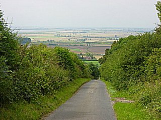
 It is uphill on leaving Brantingham
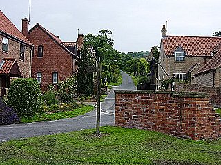
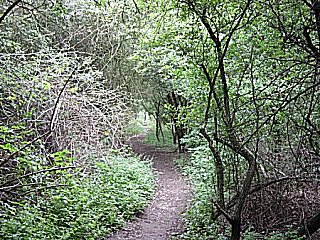 Leave the road to enter woods near South Wold
The quaint village of Brantingham can be found just off the M62 about two miles due west of Hull. It is a delightful peaceful haven with a village green and village pond that has the friendliest ducks around. They were so inquisitive while I was putting my boots on before setting off on this walk. The village green is the starting point for the walk. You leave Brantingham by walking in a north easterly direction up a metalled road towards Wandhills Plantation. Do not follow the signpost in the first picture as that will lead you to the High Hunsley circuit which is not the objective here. As seen in the photograph you begin the walk with a moderately testing uphill climb. When you reach the plantation you will see a sign that tells you to take a right turn into the woodland. Follow a distinct path that leads you into the picturesque South Wold Plantation and beyond it to Elloughton Dale. As you leave the plantation you descend steeply to another metalled road. When you meet the road turn left and follow the road for about 250 yards until you see a signpost leading you up a wooden path back into the woods.
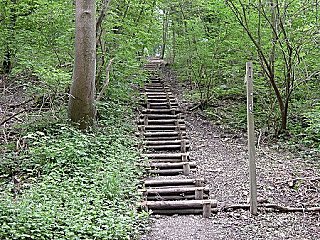 Step off the road into Wauldby Gates Plantation
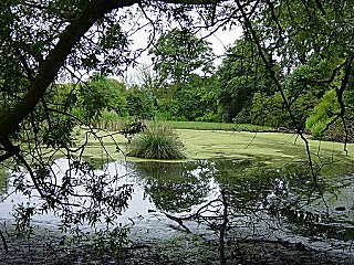 The pond at Wauldby Dam
Follow the steps up into the Wauldby Gates Plantation but be careful once you reach the top. On completing the steps you are faced with a crossroads with signs pointing in all four directions. You need to take straight line course following the High Hunsley circuit on a south easterly course. This leads you to another metalled road. Turn left and walk uphill past Welton Top stables. After the stables the woodland on your right ends. This is your cue to turn right and follow an unmade bridleway which is followed for about 400 metres until you fork left onto a path that leads onto the open wolds. Up until now most of the walking has been in enchanting woodland and on quiet roads. Now you are in the open. The track leads you along field edges past Wauldby Manor Farm and a pond created by Wauldby Dam.
 Looking west to rural landscape from Wold View
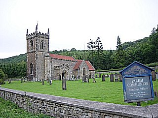 Brantingham Church
Carry on due north past the dam until you reach Turtle Hill. Here you need to turn left and follow a due westerly path. As you do so the views disappear because you follow a narrow copse way for half a mile until you reach Bottom plantation. Leave the plantation onto a road with a T junction. Follow a due west path on the metalled road that leads you to Long plantation. Keep going due west through the plantation and you eventually arrive at the driveway to Wold View Farm. The farm is aptly named as the views over all western Yorkshire open out in front of you. On a clear day you can see for miles. Try counting all the different power stations while you pause here. From here it is downhill. Walk down the road that you originally walked up passing the spot where you originally turned into the woods. Shortly after that point turn right and follow a path to Brantingham Church. The pond, your starting point is a short walk from the church back into the village.


