Market Weighton, Hudson Way, Goodmanham, Londesborough and Towthorpe
A lovely walk to from Market Weighton to the surrounding villages of the popular market town
Google Maps Open Source Maps| Statistics and Files | ||
|---|---|---|
| Start: Market Weighton | Distance: 7.5 miles (12 km) | Climbing: 158 metres |
| Grid Ref: SE877418 | Time: 3-4 hours | Rating: Moderate |
| GPX Route File | Google Earth File | About Market Weighton |
| Statistics | |
|---|---|
| Start: Market Weighton | Distance: 7.5 miles (12 km) |
| Grid Ref: SE877418 | Time: 3-4 hours |
| Climbing: 158 metres | Rating: Moderate |
| GPX Route File | Google Earth File |
Ordnance Survey Explorer Map (1:25,000)
Summary: A walk from Market Weighton to Goodmanham and Londesborough on the edge of the Yorkshire Wolds. These East Yorkshire villages are home to two of the finest examples of Norman period churches. The walk also takes us through Londesborough Park and through the medieval village of Towthorpe although there are just a few mounds indicating the location of the old site last inhabited over 400 years ago.
The Walk:
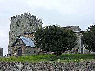 All Hallows Church, Goodmanham
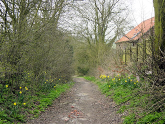 Path from Goodmanham to Beggar's Bush Well
I did this walk on a crisp late winters Sunday. It was cool and overcast but with no expectation of rain I began my walk from Market Weighton in anticipation of a good Sunday morning walk. The town of Market Weighton is a quiet place since the town bypass took the traffic away. It reminded me a little of Shap in Cumbria that died as a busy community the day the M6 came. However, the locals of Market Weighton have not totally given up as Shap seems to have done and the town retains a local charm. I walked out of the town passing courtesies with a few locals by passing the town church. The graveyard is the resting place of William Bradley who at 7 feet 9 inches tall was England's tallest man. The town celebrate his life every year by holding a Giant Bradley day every year.
Back to my walk and I left the town by following the Hudson Way, a walk from Market Weighton to Beverley that follows the course of the abandoned railway line between the two towns. I left it a road crossing and followed the road briskly uphill into the village of Goodmanham. This is a super village with a pagan history. It was the site of Delgovine, a pagan temple. It was dedicated to the god Woden and was the main site of pagan worship in the north of England. When Christianity reached the village in circa 1620 the heathen temple was demolished by Edwin, King of Northumbria, a Christian convert who was baptised in a church on the site of York Minster. All Hallows church was built in Goodmanham to accommodate the village converts. The sacking of Delgovine temple is depicted in one of the stained glass windows of the Norman period church. I had a good look through this village with a history before carrying on with my walk.
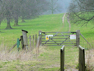 Londesborough Park
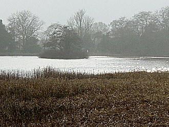
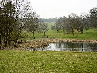 The Lake in Londesborough Park
I left Goodmanham by walking down a lane and under an old railway bridge. I was now following the Wolds Way and walked around the edge of ploughed fields to Towthorpe Corner. There is a picnic site here by the side of the A614 road which can be followed from here all the way to Bridlington. I was not going that way and crossed the road to follow a field line to a track which leads to Easthorpe Farm. This section was the most elevated part of the walk at 80m and provided good views of the low land to the west. After a short while on the track I dropped into Londesborough Park. I walked down to the Lake where there were a few Moorhens to keep me company. I gazed upon the Lake for sometime as the hazy winters sun had briefly popped out to give the Lake a wonderful silvery shimmer. I spent a lovely ten minutes at the Lake and the climbed up through the park to Londesborough village. This is a very quiet village set off the main roads and has some excellent buildings scattered around. There are super enviable private dwellings as well as Londesborough Hall and All Saints Church. I sat on a park bench near the church to have a drink and a sandwich while soaking in the pleasant atmosphere of the village.
 Haven for Wild Fowl
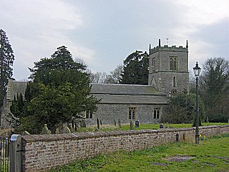 All Saints Church, Londesborough
Too soon it was time to leave and I followed a bridleway to Towthorpe Grange which is the park lodge house. Here I passed over the remains of the abandoned Towthorpe medieval village and then walked through fields back to Market Weighton. The last of these was called Weighton Clay Field and it was exactly that having being recently ploughed. I stuck to the untouched central path which had been fairly well compacted by other walkers feet. I would have got blathered in mud otherwise. I then followed a footpath into town and soon was back at my car to complete a lovely days walk. There were lots of interesting sights on this East Yorkshire walk and plenty of historical connections. I enjoyed it.


