A walk to Ben Nevis
This walk is another marvellous contribution by Ken Brockway, a regular guest contributor whose walk reports are always a full of interest. This walk is a description of Ken's planning, thoughts, preamble and ultimate ascent of iconic Ben Nevis, Great Britain's highest mountain.
Google Maps Open Source Maps| Statistics and Files | ||
|---|---|---|
| Start: Glen Nevis Visitor Centre | Distance: 10.6 miles (17 km) | Climbing: 1,374 metres |
| Grid Ref: NN123731 | Time: 4-6 hours | Rating: Strenuous |
| GPX Route File | Google Earth File | About Ben Nevis |
| Statistics | |
|---|---|
| Start: Glen Nevis Visitor Centre | Distance: 10.6 miles (17 km) |
| Grid Ref: NN123731 | Time: 4-6 hours |
| Climbing: 1,374 metres | Rating: Strenuous |
| GPX Route File | Google Earth File |
Ordnance Survey Explorer Map (1:25,000)
The Walk:
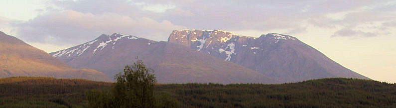 The awesome view of Ben Nevis from the north
It is a good feeling to achieve something special, so to reach the summit of Scafell Pike (978m) the highest point in England gave me a buzz even though I shared my achievement with scores of folk all around me. I can't recall if I did Snowdon (1085m) first or second, is it the cafe on top or the option of an easy ascent by railway that makes it far less fulfilling after a walk up the Llanberis path.
Perhaps it was the 'Troubles' that made us ignore the forth peak, Slieve Donard (849m) in Northern Ireland. Now there's talk of adding Snaefell (621m) on the Isle of Man, so I am happy to restrict my ambitions and stay on mainland UK although with a little more resolve I could always go further afield.
Having stayed at a Bed and Breakfast within sight of Ben Nevis some years back I had regretted not making the effort and time to attack it on that occasion. Now with a trip planned to Fort William the final summit was firmly on the itinerary. Chatting about my plans to Malcolm who had done a lot of climbing in the area, but never been to the summit???? I was offered advice and a leaflet explaining in some details how to find the route down in the event of bad weather.
"From the summit.........Beware of the steep drop into Gardyloo Gully on your right........ There is a natural tendency to steer very slightly to the left in order to keep away from the north face. The effect that this slight deviation can have, is to put you onto the steep and potentially fatal ground at the top of Five Finger Gully."
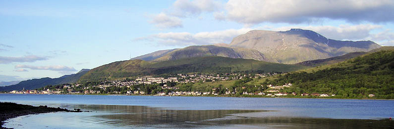
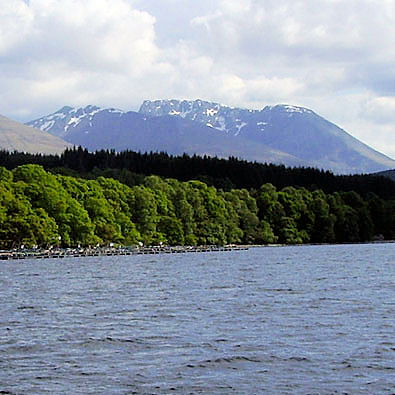 Ben Nevis from Loch Lochy
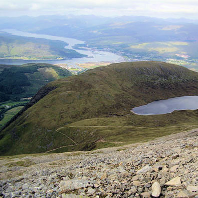
 View from the slopes of Ben Nevis to the Great Glen
Challenge number one, getting the navigation right. From careful study of the guidance and map I plotted the path into the GPS and would pack this along with other emergency kit. Challenge number two, the weather. On arrival at Laggan, for our week's cruise on the Caledonian canal, the captain said we would head south across Loch Lochy to Gairlochy. From here I had an excellent view of Ben Nevis, the sun shining on the summit, how I pined to be up there right now. I am not one to venture abroad, but I am told that in certain countries you can be confident that the sun will shine for day after day. Those who have enjoyed this certainty also tell me that's what they like about the UK, it's unpredictable climate, no good when planning a trip such as this. Next morning the top was lost in cloud. We boated up to Inverness and back during a week in which the weather could have been better. Having booked four nights in Mallaig before setting off south, and with one day scheduled for a trip on the West Highland line, win or lose I committed to Saturday after we returned the boat at 9am.
 The zig-zag path
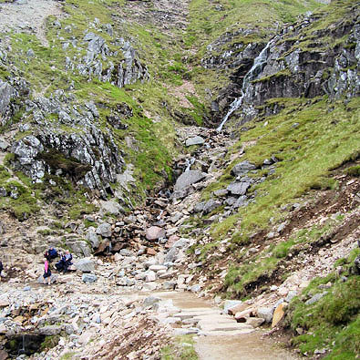
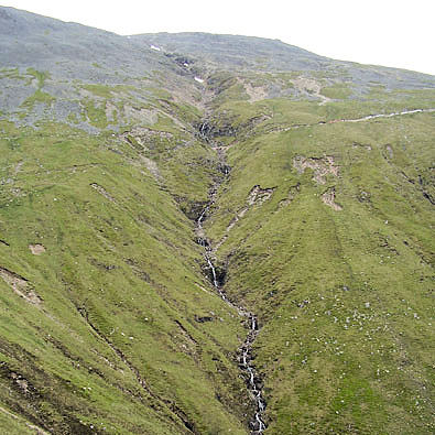 The path crosses a stream
It was June, this is National Three Peaks Challenge time, the base camp car park was packed with cars and minibuses. My chauffeur dropped me among the throng of logoed groups fresh at the very start of their gruelling task. I'd read that for the 24 hour challenge it was best to start here in the evening and then drive overnight to Wasdale, but here they were making a mid morning start on the big one and they had just five hours for the round trip.
Challenge number three, was I up to a climb of one thousand, three hundred and seventy four metres? It was not over hot so I'd taken a litre of water a sandwich plus a few crunchy bars. Together with spare layers including waterproofs then maps, compass, GPS, plasters hat, gloves and spare socks. The week had not been one for shorts so I decided to keep the legs covered but set off in just a tee shirt.
 Waterfall on Ben Nevis above the path
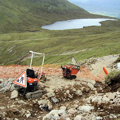 Path repairs, the modern way
Having once been the proud owner of a pre-war Austin Seven I had heard the story of such a car reaching the summit in 1928 so I was not expecting the staircase type climb of Scafell Pike. Things must have changed however in those eighty years because in places at the start I had to wait at narrow sections to pass walkers on the way down. Each short breather was most welcome and I continued with this technique of short pauses as required to catch my breath.
It's not a good idea to eat during a climb and perspiration was not extreme so I required only limited liquid replenishment. I was surprised to find folk gulping liquid on the lower slopes and wondered what they had in reserve for later. I soon realised that only when I stopped did others pass by, but I soon passed them at their next respite. A few jogged back down but I saw no one attempting other than to walk in my direction.
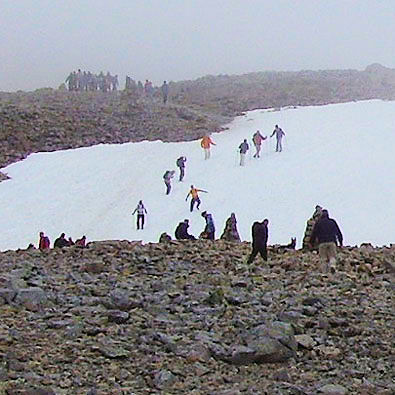 Crossing the snow line
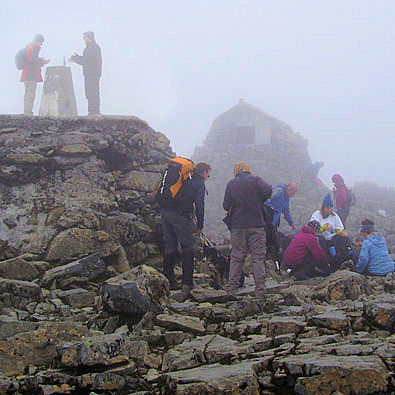 Crowds at the Trig
The path zig-zags to maintain a steady grade, there is now little if any sign of the direct short cuts and use of these is frowned upon because of the erosion caused by speed merchants. It was not an easy climb but neither was it over strenuous, my legs felt fine and with an occasional break the lungs were coping so I plodded on concentrating on the task in hand. I took no pictures on the way up, I was coming back the same way so unless the cloud came down the views could wait for the return.
I knew the top was in cloud, I had also seen the north face still had snow cover, as I entered the mist it was time to add a layer and soon another after the weak sun disappeared. Had I forgotten my gloves?
I carried on without a proper search having now donned a hat. I hit the snow line, first to the side of the path then to an area to be crossed on a steep slope, okay on the way up, fun or dodgy on the way down.
Onward and upwards until finally folk were standing about, it must be the summit? It was the summit and there it was cold, foggy busy and littered. I can't understand why, if someone has carried a plastic bottle full of liquid to this remote location, they can't carry the empty bottle back down. Hiding it under a rock is no excuse.
 Ben Nevis, a few days later!
Shame I couldn't look down into the Great Glen and see where we had travelled by boat the previous week, but then perhaps it was a good job I couldn't see the steep drops. I had my picture taken, not for publication, then set off back, it was too cold to sit here for lunch.
Be prepared is a very sensible approach to life so I would not suggest anyone attempting this walk without careful planning but even with the top in cloud and a section of the path covered in snow it was impossible to get lost. The path is extremely well defined by the passage of the estimated 125,000 visits each year. During my walk both up and down I was never out of sight of the person in front so unless someone suddenly took the flock in the wrong direction, we followed like sheep up the winding path to our common goal.
On the way down I had time to study the views and those still making the climb, then consider their chance of success? I feel very sorry for the slower members of a challenge team put under pressure to turn round when the allocated time has expired. I say forget the team challenge, do your own thing, in your own time and get to the top and have time for a pint on your return, bliss.
Walk report and pictures kindly provided by Ken Brockway.


