Malham, Kirkby Fell, Langscar Gate, Watlowes and Malham Cove
A walk from Malham village, the first half in quiet beautiful countryside and the second half to the most famous sight in the Yorkshire Dales National Park
Google Maps Open Source Maps| Statistics and Files | ||
|---|---|---|
| Start: Malham | Grid Ref: SD 90082 62874 | Distance: 6.9 miles (11.1 km) |
| Climbing: 513 metres | Time: 3-4 hours | Rating: Hard |
| GPX Route File | Google Earth File | About Malham Cove |
| Statistics | |
|---|---|
| Start: Malham | Grid Ref: SD 90082 62874 |
| Distance: 6.9 miles (11.1 km) | Climbing: 513 metres |
| Time: 3-4 hours | Rating: Hard |
| GPX Route File | Google Earth File |
Ordnance Survey Explorer Map (1:25,000)
Summary: I have walked to Malham Cove on many occasions and it is always nice to work out a variation to the classic walk. Some years ago, in the time before digital cameras, I recalled walking down a lovely country lane from Malham which was bereft of crowds yet stunningly beautiful. But where was it? Examining the map closely I decided it had to be the lane heading north west past a series of Barns to Hoober Edge. Studying further I worked out I could climb to mysterious Kirkby Fell and take it from there. The seeds for this walk were sown.
The Walk:
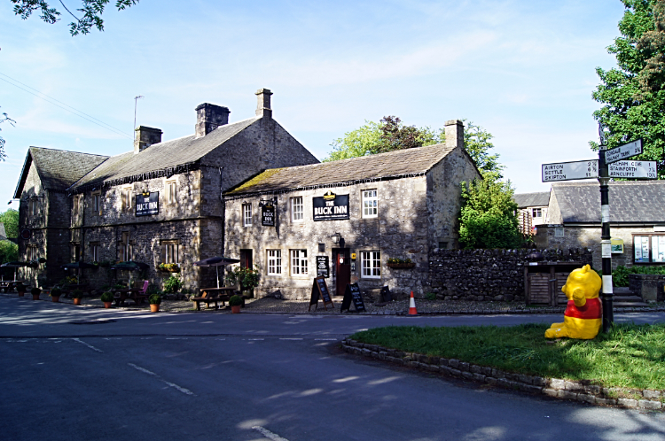 Winnie the Poo visits Malham
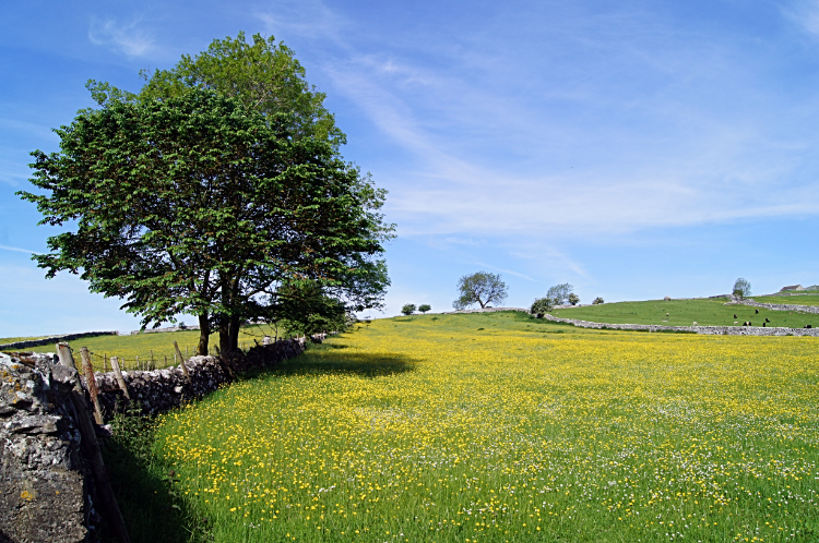 Gorgeous Buttercup meadow
I do not know what was going on in Malham village but there were huge inflatable characters everywhere. First I saw a life size scary Rabbit at Malham Smithy and next the main character from Finding Nemo swimming under the village road bridge. Then after meeting Winnie the Poo at the road sign on the village green I decided enough was enough. "I must get out of here." I thought and hastily found access to the lane I was looking for. The unnamed bridleway leading north-west took me on a steady climb out of the village. As I rose above the height of the house roofs in the village I could see across to Malham Cove. It was just 9.00am on the last day of May but the sun was already high and the day already warm. I knew I was in for a treat, Buttercup meadows providing my first heart warming moment of the walk. So beautiful they were. However, I was not prepared for the thrill waiting for me around the corner.
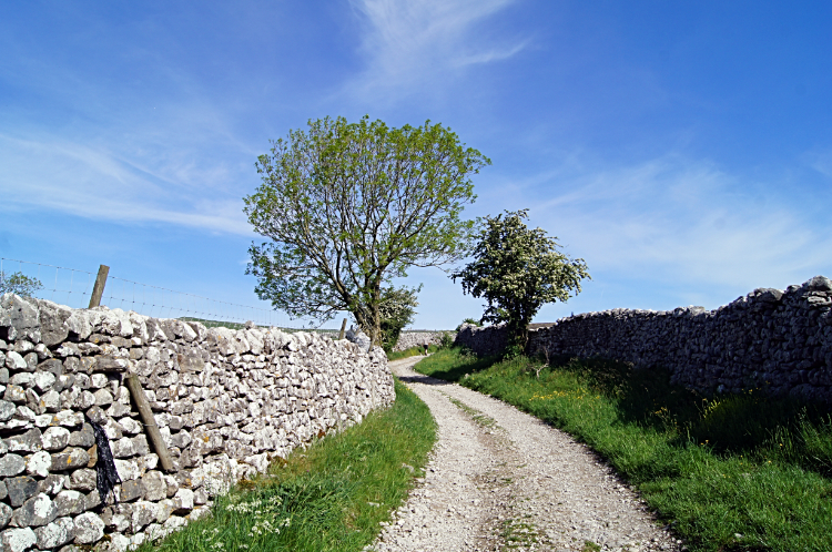 The Barns Road from Malham to Hoober Edge
 Hoober Edge
I have named this bridleway Barns Road as I passed Burns Barn, Fields Barn, Great Heads Barn and Butterlands Barn along the way. When I was looking across another colourful Buttercup meadow to Great Heads Barn though my eyes saw something dropping down to land in the field. "What was that?" I though and moments late I had my answer. A Barn Owl rose from the field with a Vole or Mouse in its beak. It was just too far away for me to get a picture and I was too transfixed watching it anyway so I just watched it majestically and effortlessly fly back to Great Heads Barn where it must have its nest. And Owlets waiting for their breakfast perhaps. It was a magical moment on what was already a fantastic walk on a brilliant sunny day in the most spectacular countryside.
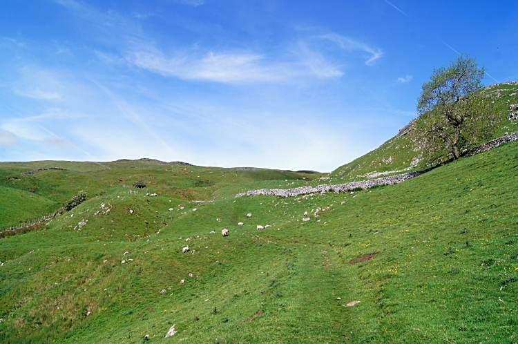 The climb from Hoober Edge
 On top of Kirkby Fell
That most delightful walk along the bridleway took thirty minutes, twenty to walk and ten to watch the owl and talk to a farmer on a quad bike taking stock of sheep in one of the enclosed fields. That was fine, nice and easy. Now though I had to put my mind to making a bit more effort and start climbing for the first time this particular day. I had climbed 60 metres from Malham to Hoober Edge, 1.5 kilometres distance. In the next 1.5 to Hanber Side and on to Kirkby Fell I would climb almost 300 metres but then all the days ascending would be done. It was slow going though in the heat of the day. Getting towards midsummer, though officially the last day of spring, the sun was high and beating down. It took me 45 minutes to cover the ground. I was not rushing, nor was I lingering. Sheep I met on the climb were more inquisitive than most, perhaps not used to seeing people. This path was clear but seldom used compared to what I would tramp along later. And all the better for it. Eventually, after the heaving, pausing, wiping of my brow, standing taking breath and steady climbing I reached the summit of Kirkby Fell. It was just me and the random array of stones on the fell top for the nest fifteen minutes and I took a rest, had a bite to eat and drink to quench my thirst. It was lovely looking over to the east with the gnashes of Malham Cove and Gordale Scar seen as parallel bites into the land and then to the pastoral Dales land laid out as a pretty table top to the south.
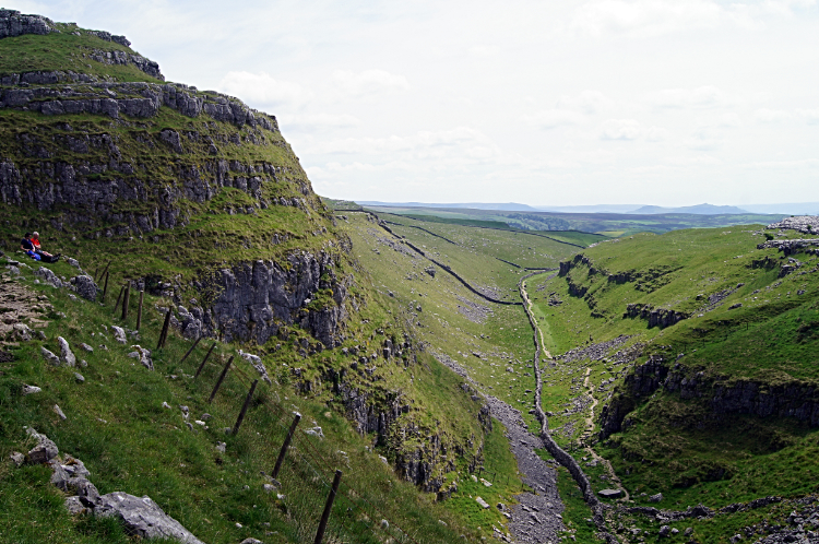
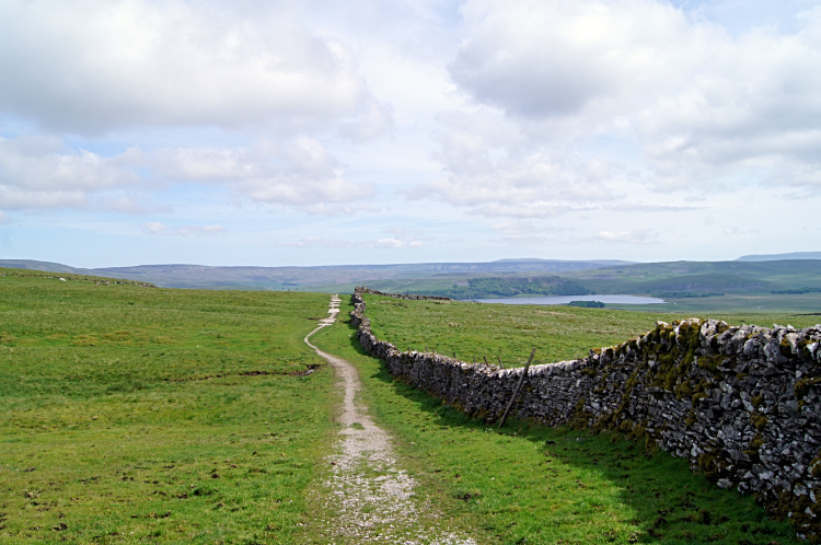 Path from Kirkby Fell to Langscar Gate
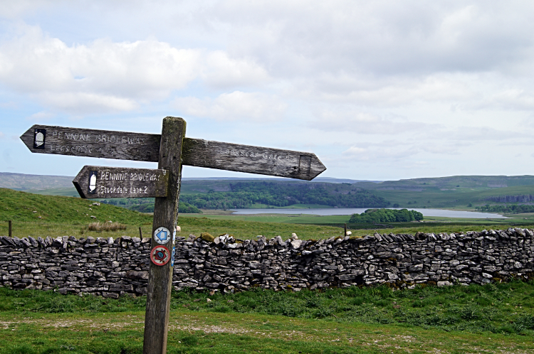 View to Malham Tarn from Langscar
Time to move on arrived all too soon and so when up on my feet I left Kirkby Fell with its magnificent views by heading north to join the Settle to Langscar Gate path which I was so familiar with. Most times I had walked it westwards, heading for Attermire Scar before dropping down into Settle but this time my course was eastwards. A straight line path running alongside a drystone wall pointed my direct way for the first part with the enticing sight of Malham Tarn taking the eye. I was not visiting the tarn this time around though and so after a little over a mile of walking from Kirkby Fell I turned from north to east, away from the line to the tarn, and instead heading directly to Langscar Gate. Arriving at the road at Langscar Gate I came to the cars parked by the roadside. And to my first sets of people, a complete contrast to my solo walk thus far.
 First glimpse of Watlowes
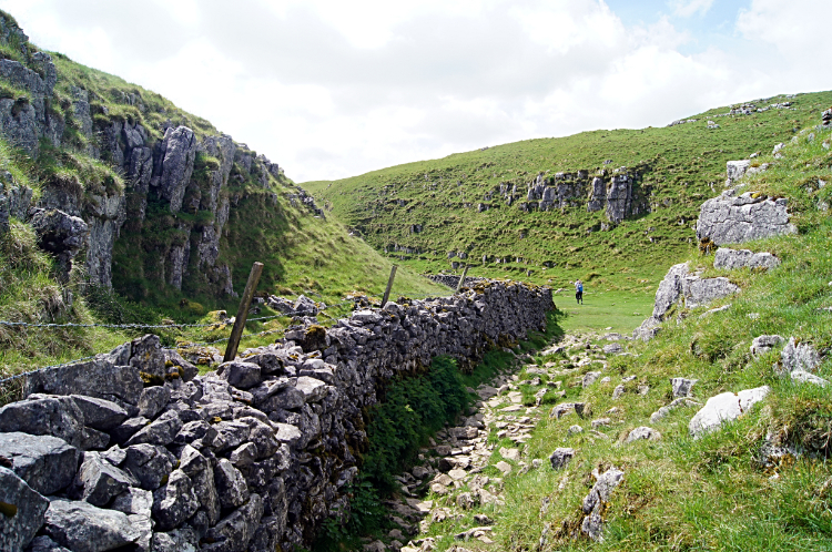 Beautiful limestone country
Shiny white limestone outcrops were becoming more prolific from here on. First, noticeably, were the white cliffs of Dean Moor Hill which I passed on the way to Malham Tarn. But not going to the water I made an about turn, almost a full 180 degrees, to join the Pennine Way path just before the Malham Tarn Road. Now I was entering the great phase of the walk through the most magnificent limestone spectacles of the entire Yorkshire Dales. Malham Cove may be the superstar of the show but there are many supporting acts in the royal variety performance of limestone country over the next hour of walking. The walk of magnificent spectacle began by tracking south on a narrow limestone path beside a drystone wall in the direction of Comb Hill.
 Following the Pennine Way to Malham Cove
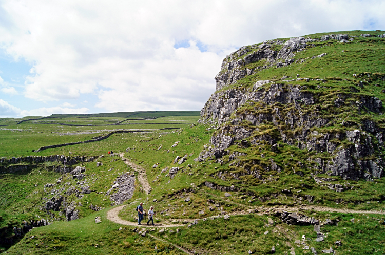 Comb Hill
I was not alone now, plenty of other walkers on the path. A group of seven, four adults and three youngsters were heading north toward Malham Tarn. I had stepped off the path and found a comfortable limestone seat opposite Comb Hill to watch them walk by. More people followed, a couple and then two lads. Nobody was in a particular hurry and nor was I. Sat for ten minutes, enjoying the rest and taking it all in. A lone walker then came by, heavily laden with backpack and camping gear. Surely he was walking the Pennine Way. After taking my fill of watching the stirrings on the corner of Comb Hill I resumed my walk. To Watlowes and toward the natural cathedral of Malham Cove.
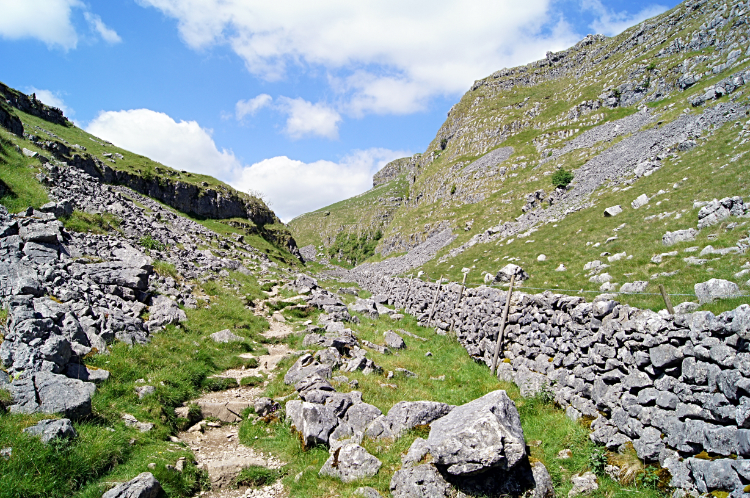
 Watlowes
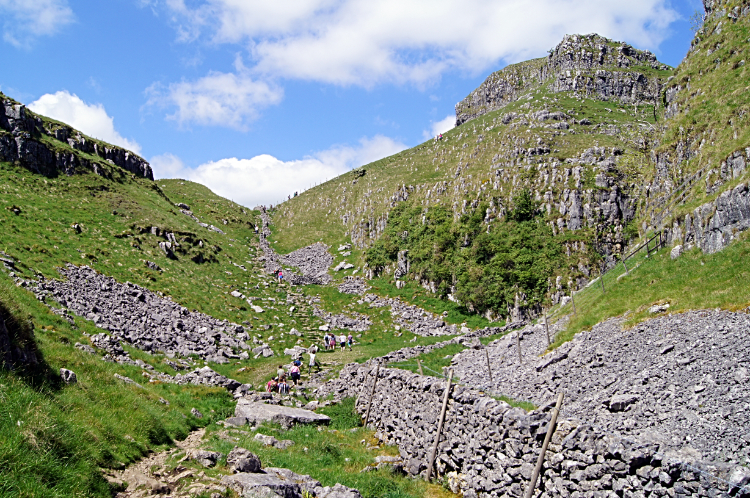 Ing Scar
The view of Watlowes which emerges when rounding the south side of Comb Hill is one of my favourites views in all of the Yorkshire Dales. The dry valley line with the low cliffs of Ing Scar guarding the prevailing west side are a sight to behold. Despite having being sat for ten minutes a moment or two before I was forced to stop and look in silence at the joyful sight. Some of the best limestone country was laid out right before me. After the break to observe and after the clamber down into Watlowes I was stopped once more, this time by a visitor with a question or two to ask. A gentleman from the USA was on his way from Malham Cove to Malham Tarn and we engaged in a convivial conversation about the geology and history of the ground on which we were standing. We talked about the theory of a river once running through here from Malham Tarn and spilling over Malham Cove. I mentioned that though I have never seen the valley anything but dry that during December 2015 heavy rains from Storm Desmond caused water to flow through Watlowes to Malham Cove where a spectacular waterfall developed. People refer to it as a once in a lifetime event and though I never saw it live the scene of water cascading over the cove was truly awesome. We agreed that would have been something to see.
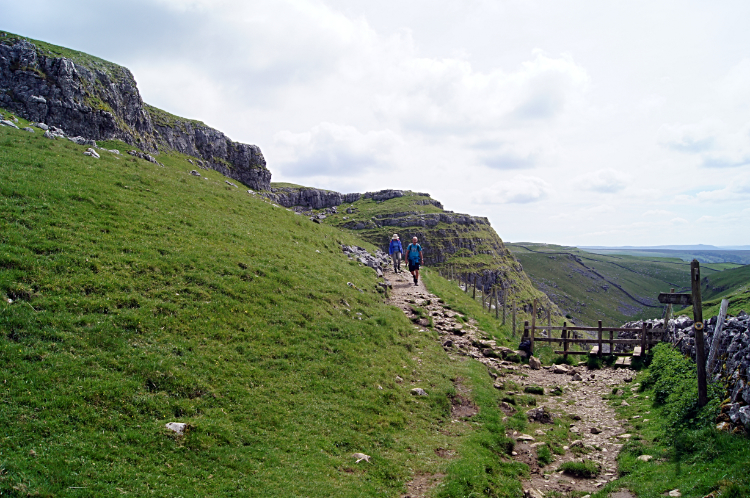
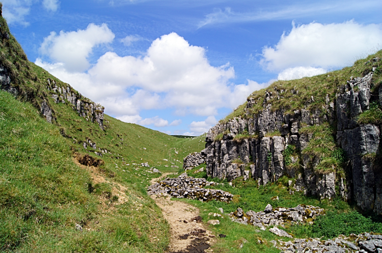
 The path through Watlowes
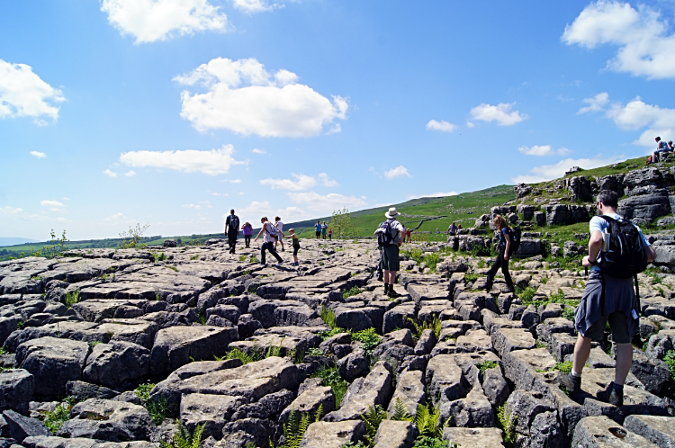 Limestone pavement of Malham Cove
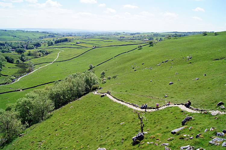
You cannot rush through the 'Dry Valley' that is Watlowes for limestone rocks and erratics caused by falls from Ing Scar make sidestepping and temporarily leaving the path a regular event. It is a jumble of white rock, strewn all over the place. Still, that is fun in itself and who wants to rush through this avenue of delights anyway? Not me, though the attraction of Malham Cove at the end of the chute is ever alluring. After the fun of hop, step and jump along Watlowes there it was. More fun of hop, step and jump on the most trodden limestone pavement in Great Britain. There is no challenger, Malham Cove wins hands down. As soon as I reached it I was with the crowds. Some will have walked northwards up from Malham and some will have walked southwards down Watlowes from Malham Tarn. Some will have crossed east to west from Gordale Scar and some will have approached west to east from the Langscar Gate road. All four cardinal points leading to the magnetic centre which is the limestone pavement on top of Malham Cove.
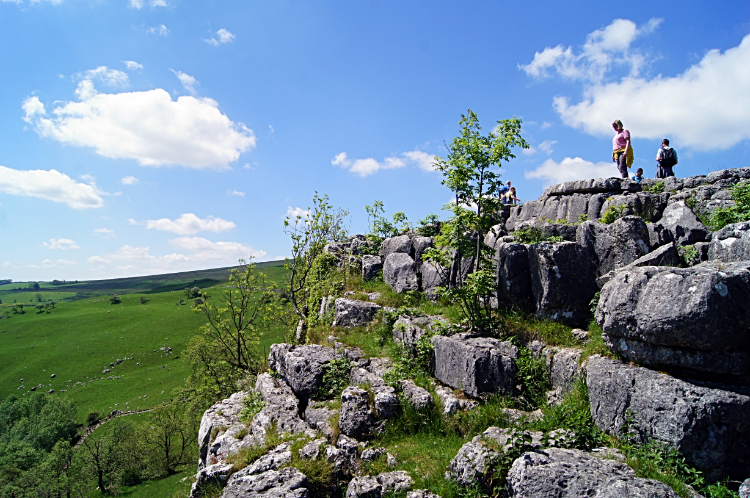 Viewing from the edge of Malham Cove
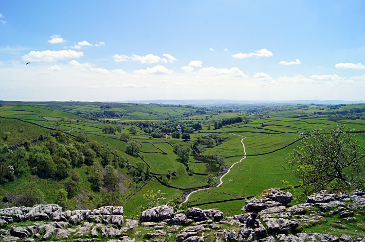 The view south from Malham Cover
There were plenty of people stepping on the pavement, all ages. Each and everyone was having fun. Then there were people assembled in a line on the edge of the cove, looking southwards, out and over the cove to Malham Village. Snaking away in a long line to the village from the cove were more people, having had their fill of fun and returning to Malham. To the left of the path of people Malham Beck trickled downstream to the village, just beyond assuming the title of River Aire. The city of Leeds own river starts right here. Anyway, such was the beautiful sight across the cove that I joined the throng of observers, sitting for a few minutes and turning my eyes in a sweep from left to right, taking it all in. I thought "There have been plenty of times I have stood here and not even been able to see the bottom of the cliff, never mind the pristine Dales country beyond. So this is really good".
 The path leading down from Malham Cove
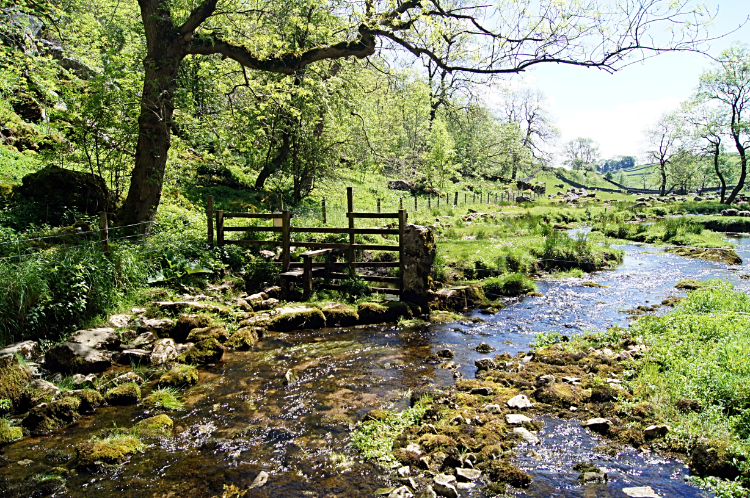 Humble beginnings of the River Aire
Down from thew limestone plateau at the top of Malham Cove I went, safely easing myself down the steep path which is mostly stepped and part sloped. It is so easy to get ahead of yourself in the haste to get down and twist an ankle or knee. so steady it was. Still, I passed quiet a few folk while nobody passed me. Perhaps I was not going too slowly down the decline after all. Anyway, safely deposited at the bottom of Malham Cove then made my way on the path leading up to the face of the cliff. When I reached Malham Beck, alias the River Aire, I stopped for another short while. This time it was a moment of nature as a group of about twenty Swifts or Sand Martins entertained me. They were repeatedly flying into a mud bank on the waters edge, collecting bits of wet mud for nest building. It was a spectacular sight watching the fast fliers swooping in, picking up a mouthful of mud and then swooping off again.
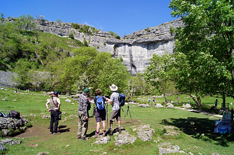 Peregrine Falcon watchers of Malham Cove
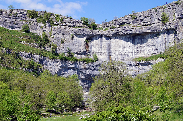 Malham Cove
The walk which had been brilliant from start to finish was almost over but there was one more interesting time to enjoy on my amble back to Malham. Not long after leaving the birds and their nest building work I reached a group of four people stood with cameras and binoculars on tripods aimed at the cove. They were RSPB enthusiasts observing the Malham Cove Peregrine Falcons. "Will I be able to see one flying?" I asked. "Probably not, they were busy earlier and a little while earlier made a kill" was the answer. A chap said they had chicks which would now be feeding while the adults rested. Oh well, I had enjoyed my fill of spectacles anyway and I said to the group "Earlier, on the other side of the village, I saw a Barn Owl make a kill of its own". They were impressed by that though it seemed such a long time ago, such had been all the thrills I had enjoyed in between. Back to Malham I returned where groups of children on safari with adults in charge were walking to find more inflatable animals. I saw a Zoo full. Something was going on.


