The classic mountaineering circuit to England's highest summits via the dramatic Corridor Route. Highlights include Stockley Bridge, Styhead Tarn, Lingmell Col, Lord's Rake, the rooftop of Scafell, Mickledore, Scafell Pike, Broad Crag, Great End, and the cascading descent of Grains Gill.
Summary: I find this route to the highest point in England very special. There is so much to enjoy including Stockley Beck, Stockley Bridge, Taylor Gill Force, Styhead Tarn, Lingmell, Pulpit Rock, Lord's Rake, views to Wast Water, Scafell, Foxes Tarn, Mickledore, Broad Stand, Scafell Pike itself, Broad Crag, Great End, Esk Hause, and the walk back to Seathwaite which provides superb views of Borrowdale. The walk is not overly long at 11 miles, but it is strenuous—over 1,500 metres of climbing! The achievement at the end is intensely satisfying.
The Walk Report
An early start from SeathwaiteWalking alongside Styhead Gill
There are various ways to tackle the Scafell peaks. My favourite way is from the farmstead at the terminus of the road at Seathwaite in Borrowdale. The start is brilliant in itself, the first mile being a delightful easy stroll to Stockley Bridge. Whilst doing this warm up I am always drawn by the sound to my right and watch the crystal clear water cascading over the rocks of Grains Gill. It is a beautiful sight to behold and the gentle gradient to the bridge eases the legs into the day's walking.
Relax a moment on the bridge and enjoy the sights and sounds around you because after crossing the bridge and passing through a gate, the next half mile is the first exerting climb on the quest to reach the highest point in England. The ascent climbs from around 150m to 400m in no time at all. I promise the unwary walker, you will feel it by now.
Passing Styhead TarnLooking back to Styhead from Stand Crag
At 400m you resume a level path to Styhead Tarn, a place that can be tranquil in clement conditions but not a place to dwell if the weather has closed in. Here the walker has the first views of the Scafell peaks, an inspiration to move onwards. Shortly after leaving Styhead Tarn turn 90 degrees to the left and then a couple of hundred yards on turn 90 degrees to the right to tackle the Corridor Route that will lead you to Mickledore.
The Corridor Route is rocky in places and at one point there is a steep scramble down a rocky ledge where you are required to use your hands as well as your legs. In wet conditions the going can be a little tricky for the inexperienced walker but with care most people will manage this obstacle with little problem. The advantage to this route is that the extra bonus of a diversion to Lingmell is an easy one, providing the best unbroken views of the Wasdale valley.
Scrambling on the Corridor RouteHaving a rest on Lingmell Col
Adjacent to Lingmell you reach a junction on the Corridor Route where straight on leads to Scafell Pike and the right fork takes a path down to Hollow Stones and then Lingmell Gill which flows into Wast Water. Take the right fork for a while but when it starts to lose height traverse the contours of Pikes Crag until you reach Pulpit Rock with Mickledore dead ahead just below you.
Drop down to the Mickledore ridge that links Scafell with Scafell Pike. You will know when you are there for there is a large mountain rescue box halfway along the ridge. The next challenge is to scramble down the edge of Mickledore where it abuts Broad Stand to the beginning of Lord's Rake.
Lingmell and Great GableWast Water as seen from Pulpit Rock
Lord's Rake is a favourite of mine. It is a steep gully and a tough hurdle to overcome as scree baulks your steps and slows progress. The end result is worth every effort, truly fantastic as you step out of the Rake; by walking a little to your right you get the most exhilarating bird's eye view of Wast Water.
Scrambling up the scree in Lord's RakeCelebrating on Scafell
Dwell a little here and then push onto Scafell itself. Hit the top at a lofty 964 metres and move on, Scafell Pike awaits. Cross to the right of Broad Stand and drop down to Foxes Tarn, continuing past this small tarn down the gully until you reach a path that takes you back up to Mickledore with Broad Stand to your left.
Broad Stand and MickledoreWalking to the summit of Scafell Pike
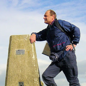
From Mickledore move straight up to the Pike. Soon the deed is done, the highest point in England is reached and weather permitting, a good place to take stock of your achievement and enjoy a food break. I always look forward to the treat.
The best route back to Seathwaite is by leaving Scafell Pike in a north-easterly direction down to a gully and directly up to Broad Crag. You can scramble to the rocky top or skirt it to your right, continuing towards Great End. There are opportunities galore to peak bag here: Great End stands at a proud 910 metres, and Ill Crag (England's 4th highest peak at 935 metres) is easily reached just 300 metres south-west of Broad Crag.
The top of EnglandScampering down Dropping Crag
If you choose to bag Great End you will need to backtrack to the path where it forks off due east to Esk Hause. From Esk Hause where paths cross, walk north-east down to a shelter where another path crosses. Here the walk continues north-west towards Sprinkling Tarn and Sty Head. Leave the path by taking a right turn just before Sprinkling Tarn and head back to Stockley Bridge following Grains Gill downstream.
Grains GillGreat services keeping vigil for late finishers
On the return trip I stopped at Stockley Bridge and gazed at the crystal clear water flowing down from the highest fells in England. I always do so when returning this way. You simply have ten minutes of gentle walking left to retrace your earlier steps back to Seathwaite Farm. And once you finish the walk, you are allowed to celebrate with delight. You will have deserved to do so!