Danby, Castleton, Castleton Rigg, Danby Botton and Danby Rigg
My first walks on the moors, as a young boy in the early 1960's, are as vivid in memory today as they were back then. Born on the Vale of Mowbray I could see the North York Moors in the distance from my home village and some summer weekends were always a thrill in the anticipation of a picnic up on the moors. I clearly remember playing in the Heather with my brothers and exploring the moorland around Osmotherley, not too far from my parents watchful eyes. I also recall Dad always putting a sprig of Heather hanging from the rear view mirror in the car and another sprig put in the radiator grill. Happy days. Here I return to the North York Moors on another sunny day with full Heather blossom to excite me, this time on the east side of the North York Moors.
Google Maps Open Source Maps| Statistics and Files | ||
|---|---|---|
| Start: Danby | Distance: 9.4 miles (15.0 km) | Climbing: 490 metres |
| Grid Ref: NZ 70810 08626 | Time: 4-5 hours | Rating: Moderate |
| GPX Route File | Google Earth File | About Danby |
| Statistics | |
|---|---|
| Start: Danby | Grid Ref: NZ 70810 08626 |
| Distance: 9.4 miles (15.0 km) | Climbing: 490 metres |
| Time: 4-5 hours | Rating: Moderate |
| GPX Route File | Google Earth File |
Ordnance Survey Explorer Map (1:25,000)
The Walk:
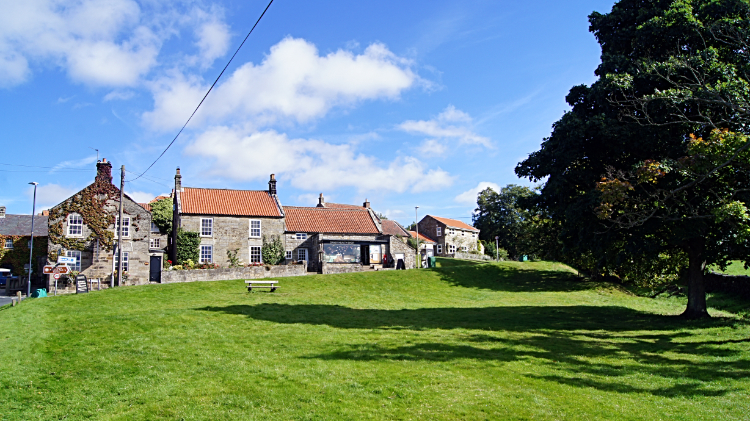 Danby village
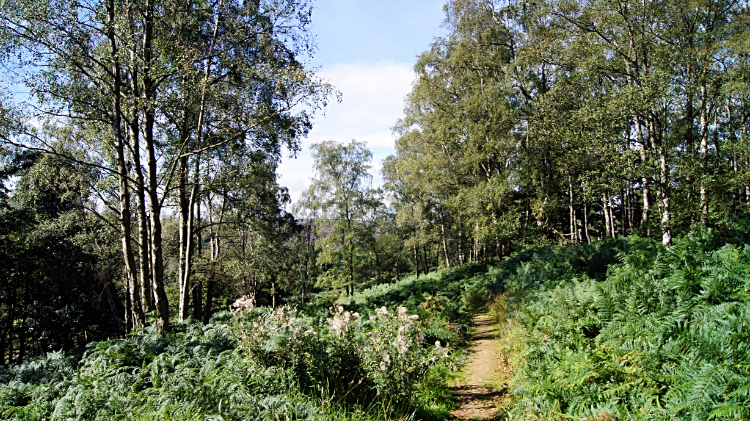 Woodland trail through Danby Park
Another lovely day in Yorkshire, the first day of September. The sun was shining all the way as I drove the sixty miles in ninety minutes from my home in Harrogate to Danby. Same county, big county. Arriving, parking up and setting off within ten minutes I was heading out of the pretty village of Danby by 10.30am and smiling all the way as I eagerly paced up the Castleton road, soon leaving it to follow the Esk Valley Walk through the luscious green woodland of Danby Park. The walk through the park led me to the Three Howes Rigg leading down from Danby Low Moor in the north. I was not going that way today, instead turning left to follow the road south to cross the Esk Valley Railway track and near to Castleton Moor Railway Station. A few more steps led me to cross the River Esk at Esk Mill, the river crossing leading to a stiff thirty metre climb into the village of Castleton.
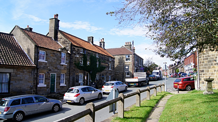 Castleton village
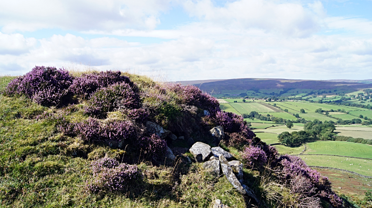 View from disused quarry on Castleton Rigg
The village of Castleton, 160 metres high at the east end of High Street and 200 metres high at the west end of High Street is full of interesting buildings. An old chapel with 'Primitive Methodist Chapel' engraved above the main door and converted for domestic living was up for sale. A ginnel between cottages leading to High Street was so nice. School, Downe Arms, more cottages, all appealing. The only shame was the amount of traffic parked on both sides of the High Street. A quiet mid-week day and still the accumulation of parked traffic was unsightly. For that reason alone I was glad to have climbed the 40 metres up High Street and turned left, heading out of the village by way of the road leading south across Castleton Rigg. After following the roadside for a while, constantly climbing the ridgeline, I veered right from the road, following a good moor path to the site of disused quarries on the west fringe of the moor. I was now entering the land of gorgeous pink. Heather was just about at its best now.
 View from Castleton Rigg to Danby Rigg
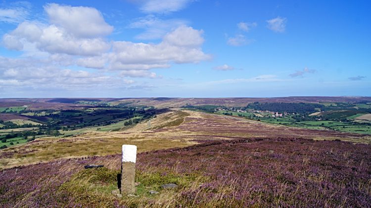
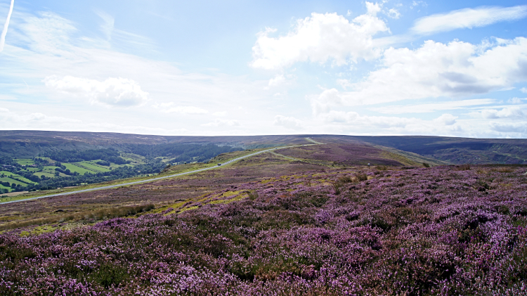 Heather blossom on Castleton Rigg
At the quarry site I stayed a while to enjoy the tremendous view across Westerdale to Baysdale Moor and to me the unfamiliar east side of the Cleveland Hills. Afterwards I took my time to stroll on any of the many paths that took my fancy crossing Castleton Rigg. There were plenty to choose from and as long as I kept my general course towards Danby Head it did not matter. I would deviate to appreciate small stone cairns and upright posts, top painted in white. Waymarkers for crossing the moor in fog maybe. Just pretty objects today. The whaleback ridge of Castleton Moor was a delight to cross.
 Descending to Danby Botton
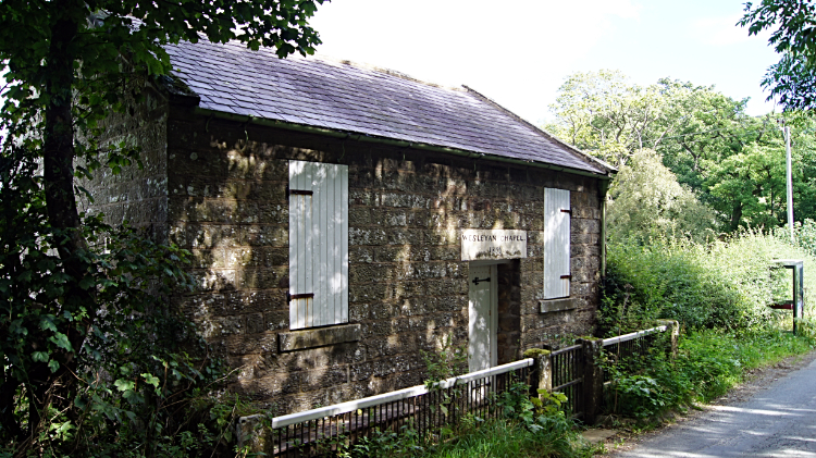 Wesleyan Chapel, Danby Botton
After two miles in one hour on the meander of Castleton Moor, in which time I climbed 120 metres without noticing, I left the pink carpet moor top to descend on a path through thick bracken to reach the road leading east towards Danby Botton. I came out of the bracken and scrub of bramble, etc with a few minor cuts. 'Note I have marked the downloadable GPS file to follow the road down as it was course in the bracken. Which way you choose is your choice'. After the effort of negotiating the thick scrub the walk along the road was utter delight. I strolled once more and as it was now after noon I started to think about lunch. First though I continued on my way on the sun dappled road past Stormy Hall and past a small Wesleyan Chapel to reach a road junction. "Great, that bench is in the perfect spot. Lunch time".
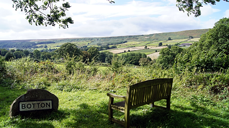 Lunchtime seat with a view near Botton village
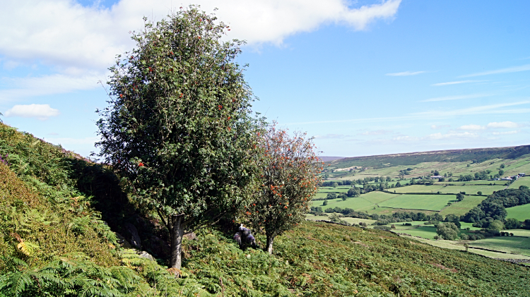
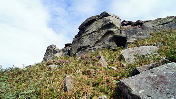 Gritstone outcrops on the climb to Danby Rigg
Near to the bench was a stone and tinplate sign to the village of Botton. A quiet place with just one road in and out it is the ideal community setting for the people with learning disabilities for which it caters. Across the road from the village sign and my picnic bench was a road sign with two destinations. One was for Stormy Hall which I had passed. The other pointed to High Farm, Falcon Farm and Honey Bee Nest in the direction beyond Botton. My way was not signposted but it was obvious. The one going up hill. So, after my lunch of enjoying the view to Danby Head and Danby High Moor I turned to my next task in hand. Climbing again, this time to Danby Rigg by way of Botton Farm and Jack Sledge Road. After the road terminated at the farm I found the path up to the moor, another one with thick scrub invading from both sides. his time I avoided more bloodings though, getting up to the outcrops shielding the moor, and beyond them to hit the top.
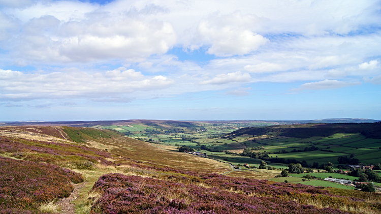 View of Esk Dale from Danby Rigg
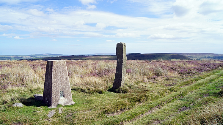 Trig Pillar on Danby Rigg, 312m altitude
I had climbed 175 metres since having lunch when I hit the top point of my walk on Danby Rigg at 350 metres high. Before I had reached the top brief stops and looks back to Danby Dale had to be enjoyed. And the view of the dale looking across to Castleton Rigg was a perfect picture. These views from the smooth and pristine shallow glaciated dales was just divine. Using the term spectacular is an understatement. And still I had another WOW moment ahead of me for after cresting Danby Rigg and edging across to Crossley Side on the east of the moor I was presented with the most beautiful view of Esk Dale in a graceful crescent sweep in the north. Esk Dale is mother of them all around here. Westerdale, Danby Dale, Little Fryup Dale which was now down below me to the right and Great Fryup Dale further east, all feed their waters into the River Esk. And nowhere is better to appreciate this than here. Where I was standing. It was a joy. It was a privilege. Able to take no more of a picture perfect assault on my senses I continued on my way, unusually descending to a trig point. The Ordnance Survey trigonometry pillar on Danby Rigg is at 312 metres almost 40 metres lower than where I stood a little earlier. But at the north end, lowering to Esk Dale, it is probably set in a better point of view.
 Danby Rigg Standing Stone
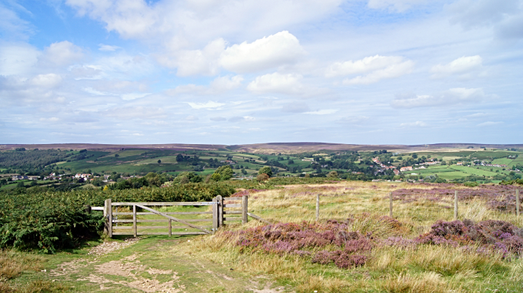 The way home from Danby Rigg
My walk on the heather moors of the eastern North York Moors was almost at an end. All that remained was a gentle walk down from Danby Rigg to the village of Danby. Along the way I passed a substantial standing stones. I wonder who put it there? The North York Moors are a prolific site for such stones, waymarks and mileposts, some named such as Fat Betty Cross on Danby High Moor which I was looking towards at lunch. Beyond the standing stone I came to a gate leading off the moor and down a track to meet the Ainthorpe road leading back into Danby. My walk was almost over, finishing with a walk through the village of Ainthorpe, past the Fox and Hounds Inn and across Danby Railway Bridge to reach the village centre. Mid afternoon and cloud filling the sky. "That was good timing".


