Cresswell Crags
Through beautiful woodland to a magnificent limestone gorge
Google Maps Open Source Maps| Statistics and Files | ||
|---|---|---|
| Start: Visitor Centre Car Park | Distance: 2.6 miles (4.1 km) | Climbing: 44 metres |
| Grid Ref: SK 53841 74380 | Time: 2 hours | Rating: Easy |
| GPX Route File | Google Earth File | About Cresswell Crags |
| Statistics | |
|---|---|
| Start: Visitor Centre Car Park | Distance: 2.6 miles (4.1 km) |
| Climbing: 44 metres | Grid Ref: SK 53841 74380 |
| Time: 2 hours | Rating: Easy |
| GPX Route File | Google Earth File |
Ordnance Survey Explorer Map (1:25,000)
The Walk: Cresswell Crags are dramatic limestone cliffs that lie on either side of a narrow gorge, which serves as the boundary between the counties of Derbyshire and Nottinghamshire. This is one of the most important places in Britain for palaeontology - the study of fossils.
 Caves at Cresswell Crags (
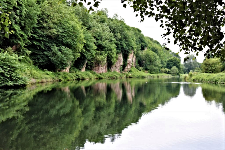 Cresswell Lake and Crags (
The walk heads through pleasant woodland before curving round to enter the gorge. Here, on either side of a pond, there are caves which were known to early man. Metal grids across their openings prevent access. The gorge is a site of special scientific interest for its geology and natural history. a variety of wild flowers and birds will be seen on the walk and the caves are a home for bats.
The crags and pond were once part of the Welbeck Estate, whose origins date back several hundred years. In 1538, Welbeck Abbey was the seat of the White Canons of a religious order founded in France. Later, the land came into the Shrewsbury and Cavendish family who owned the nearby Bolsover Castle and Hardwick Hall. The abbey is now Welbeck College and the impressive house and estate is mostly the work of the Dukes of Portland. The Riding School, as with the whole building, is built on a grand scale. In the 1700's, the Duke of Portland engaged the painter George Stubbs to paint views of the Welbeck Estate. One painting known as Two Gentlemen Going Shooting shows the mill and Cresswell Crags.
At the southern end of Crag's Pond is Crag's Cottage, once the Star Inn and the last building of a small settlement beside a watermill. The mill and thatched buildings were later demolished in the 1860's as part of an extensive landscaping project on the estate. The mill pond was drained and the lake, Crag's Pond, was made by damming the stream, to create a duck shooting lake for the Duke of Portland.
It is not possible to go into any of the caves that lie on either side of the pond, but a record of explorations and findings is displayed in an exhibition at the visitors centre. Pin Hole Cave was named after a 19th century custom of each visitor placing a pin in the rock pool near the entrance. Later, excavations uncovered more than 15,000 pieces of bone. Evidence shows that man had occupied the cave intermittently over the last 45,000 years and that Hyenas used it as a den. Robin Hood's Cave is the largest of all with four main chambers. Mother Grundy's Parlour was named after a witch who lived within it in the 19th century. Boat House Cave, as the name suggests, is where a boat for the lake was kept. When the lake was lowered in the 1930's the cave was extensively excavated. The last cave on the walk, Church Hole Cave, extends 170 feet (51 metres) into the hillside and has the finest artefacts from the area. Hyenas used it as their lair and bones from Bison, Bear, Wolf, Woolly Rhinoceros, Horse and Cave Lion have been found. The cave has been occupied by Neanderthal Man and pottery fragments show that it was also occupied in both Roman and medieval times.
Acknowledgments: Text derived from the Out and Out Series; Discovering the Countryside on Foot. Pictures courtesy of Wikipedia.


