Goodrich Castle, Coppet Hill and River Wye
From castle ruins to a magnificent river gorge
Google Maps Open Source Maps| Statistics and Files | ||
|---|---|---|
| Start: Goodrich Castle Car Park | Distance: 6.0 miles (9.6 km) | Climbing: 226 metres |
| Grid Ref: SO 57596 19675 | Time: 3 hours | Rating: Moderate |
| GPX Route File | Google Earth File | About Goodrich Castle |
| Statistics | |
|---|---|
| Start: Goodrich Castle Car Park | Distance: 6.0 miles (9.6 km) |
| Climbing: 226 metres | Grid Ref: SO 57596 19675 |
| Time: 3 hours | Rating: Moderate |
| GPX Route File | Google Earth File |
Ordnance Survey Explorer Map (1:25,000)
The Walk: In a southern corner of unspoilt Herefordshire, the beautiful River Wye meanders gracefully through the countryside, forming the border between Herefordshire and Gloucestershire. This is the start of the scenic gorge where the river flows swiftly below craggy cliffs and steep wooded slopes, making large horseshoe meanders on its way from the busy market town of Ross on Wye, past historic Monmouth, to join the River Severn beyond Chepstow. Coppet Hill is a familiar and distinctive landmark in this part of the Wye valley and from its summit of 617 feet (188 metres) there are panoramic views across the wonderful Wye valley.
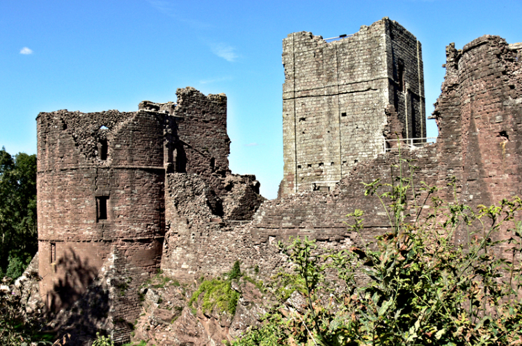 Goodrich Castle
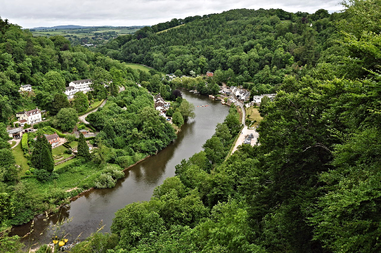 River Wye and Symonds Yat
The walk starts from Goodrich Castle. From here a short stretch of minor road offers tantalising glimpses of the River Wye before reaching a waymarked path leading up and over Coppet Hill. During the climb there is a scenic view to the left of Kerne Bridge spanning the River Wye. This fine stone bridge was constructed in 1828 after the passing of an Act of Parliament 'for building a bridge over the Wye'. On completing the climb, at the trig point, on a clear day the Welsh Hills of the Brecon Beacons can be seen. The remains of a folly can also be seen near the summit of Coppet Hill. It was built as a summer house for people to enjoy the outstanding scenery on show.
Within two miles of climbing Coppet Hill the undulating route descends to the banks of the river, shadowed here by the lofty height of Symond's Yat Rock and the Coldwell Rocks on the opposite bank. The next one and a half miles are ambled beside the river to Huntsham Bridge.
The remainder of the walk continues on pleasant paths and quiet lanes through Goodrich village with its historic church of St Giles. One of the main attractions of this walk is the finale at Goodrich Castle., founded in the 11th century by the Normans to defend the Welsh borders. The Marcher Lords, as they were known, selected a superb site guarding an ancient river crossing. However, unlike other border castles, its strength was never tested and having served its purpose, it became unoccupied at the beginning of the 17th century. It was reused for a short time during the English Civil War but in 1646 it fell into ruins, and eventually in 1920 it was placed in the care of the state.
Acknowledgment: Text derived from the Out and Out Series; Discovering the Countryside on Foot. Pictures courtesy of Wikipedia.


