Winchcombe and Belas Knap
A scenic walk from a Saxon village along the Cotswold Way
Google Maps Open Source Maps| Statistics and Files | ||
|---|---|---|
| Start: Winchcombe | Distance: 6.6 miles (10.6 km) | Climbing: 263 metres |
| Grid Ref: SP 02430 28580 | Time: 3 hours | Rating: Moderate |
| GPX Route File | Google Earth File | About Winchcombe |
| Statistics | |
|---|---|
| Start: Winchcombe | Distance: 6.6 miles (10.6 km) |
| Climbing: 263 metres | Grid Ref: SP 02430 28580 |
| Time: 3 hours | Rating: Moderate |
| GPX Route File | Google Earth File |
Ordnance Survey Explorer Map (1:25,000)
The Walk: This walk has something for all the family. The route goes to the top of the Cotswolds escarpment and offers magnificent views. There are archaeological sites, an historic castle, and beautiful formal cottage gardens. In addition, you can visit a unique railway museum and if, towards the end of the walk, youngsters have the energy they can enjoy an exciting adventure playground.
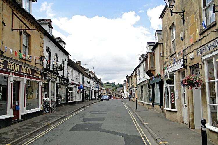 Winchcombe
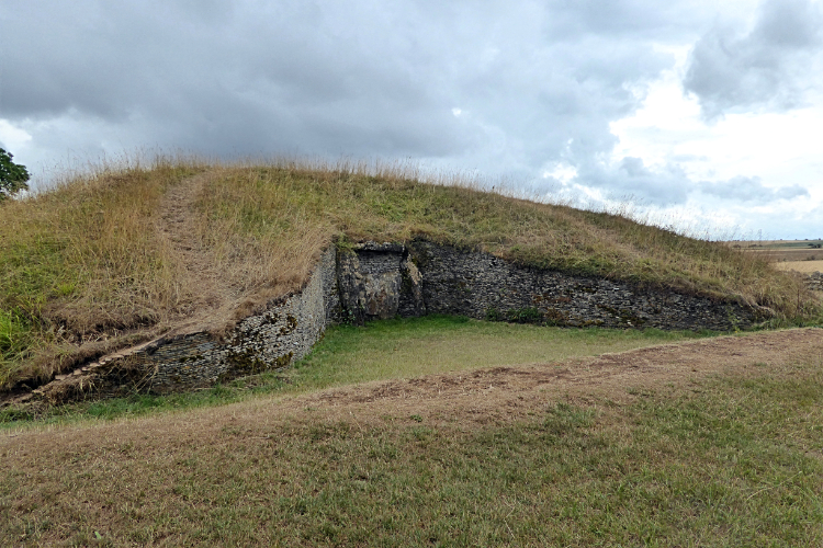 Belas Knap
The starting place is Winchcombe, a small town built on whitish limestone beside the River Isbourne. It dates from Saxon times when it was a walled city. Kenulf ruled the kingdom of Mercia from 796 and founded a great Benedictine Abbey at Winchcombe. This was to become a seat of learning and the arts and attracted prelates and pilgrims. Little remains of the abbey but the site is the magnificent 15th century St Peter's Church. It is full of interesting features inside and incorporates some stones from the original abbey. But the most startling exterior item is the array of gargoyles on the church. There are 40 in all and they may have been carved by townsfolk to represent unpopular members of the monastic order. Or even out of favour neighbours.
The powerful little River Isbourne that cuts through the town from the high wolds once powered many mills, including paper mills. There are reminders today, including Mill Lane and Silk Mill Lane. Duck Street, now Vineyard Street, indicates where the Ducking Stool to punish witches was sited. The public stocks are still displayed in the town and were in use, for the humiliation of drunkards and minor felons, as late as 1860.
The route climbs from Winchcombe past Corndean woodlands to Belas Knap Long Barrow, said to be one of the finest specimens of neolithic long barrows in the country. Built around 2,000 BC, it is 178 feet long, 60 feet wide and 18 feet high. Within there are four burial chambers. When first excavated in 1863-5 thirty eight skeletons were found together with implements and pottery. The original drystone walls of the barrow are interesting as they confirm that the waller's art has survived for at least 4,000 years. Near Belas Knap the walk joins the Cotswold Way, leading back to Winchcombe. Towards the end of the walk the route passes near to partly ruined Sudeley Castle, where collections of toys, antiques and armour make for an interesting visit.
Acknowledgment: Text derived from the Out and Out Series; Discovering the Countryside on Foot. Pictures courtesy of Wikipedia.


