Ironbridge Gorge and Coalbrookdale
Into the heart of the Industrial Revolution with a walk over the world's first iron bridge
Google Maps Open Source Maps| Statistics and Files | ||
|---|---|---|
| Start: Ironbridge | Distance: 6.2 miles (9.9 km) | Climbing: 284 metres |
| Grid Ref: SJ 67232 03304 | Time: 3-4 hours | Rating: Hard |
| GPX Route File | Google Earth File | About Ironbridge |
| Statistics | |
|---|---|
| Start: Ironbridge | Distance: 6.2 miles (9.9 km) |
| Climbing: 284 metres | Grid Ref: SJ 67232 03304 |
| Time: 3-4 hours | Rating: Hard |
| GPX Route File | Google Earth File |
Ordnance Survey Explorer Map (1:25,000)
The Walk: Ironbridge Gorge has been designated as a world heritage site for the wealth of attractions and sights that it has to offer. It is known as the birthplace of the industrial revolution, which occurred due to the fortuitous combination of coal, iron, transport and water power. The iron industry of the area was closely associated with the Darby family and their firm, the Coalbrookdale Company. The name of the valley is derived from the graceful structure of the world's first iron bridge which spans the River Severn. Ironbridge itself is perched on limestone cliffs in the middle of magnificent Shropshire countryside. The area is uniquely preserved as it has remained almost totally undeveloped for over 150 years.
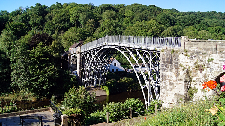 Abraham Darby III's Iron Bridge
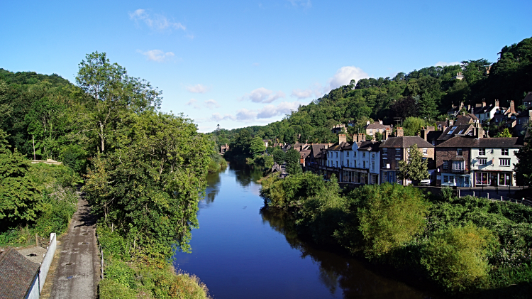 River Severn flowing through Ironbridge Gorge
Until the last 100,000 years, what is now the Upper Severn basin in Shropshire and mid-Wales drained north, joining the River Dee and flowing into the Irish Sea. However, during the last Ice Age this route was blocked and a great lake built up. The water eventually spilled over the hills to the south to reach a tributary of the River Stour and the lower Severn valley. As a result, the modern Severn turns away from the flat plain of north Shropshire to flow south through a narrow gap in the south Shropshire hills at Ironbridge. This walk starts at the Museum of the River which is housed in a Gothic warehouse built by the company to store finished goods before they were sent off down the Severn.
From the museum a back road leads up the side valley of Coalbrookdale to the Museum of Iron. This is the site of the original furnace where, in 1907, Abraham Darby first began to smelt iron ore using coke, instead of the traditional charcoal. Displays, models and exhibits trace the history of iron and the railway line carries coal from the Ironbridge power station just up the gorge. The village of Coalbrookdale was created by the company and the walk passes working men's cottages and the church, built in 1850-54 with money from the Darby family. From Coalbrookdale, the walk climbs through woods and across a corner of the plateau that the gorge cuts through. It follows back alleys through the upper part of Ironbridge, with good views across the gorge and down to Ironbridge Church and the Iron Bridge.
From Ironbridge, the path leads through woods above the river, including an area where the old system of coppicing has been reinstated. The trees are cut back every 15 years to produce new young shoots. This coppiced timber provides material for countryside items such as baskets, hedge stakes and brooms. The woodlands also hide ruined industrial buildings. Going on along the Silkin Trail, an old railway line, you pass under the Hay Inclined Plane, which raised and lowered small boats to link the Shropshire Canal to the river. A short section of the canal leads to a bridge across the river from where you return back to Ironbridge following the route of the partly restored Severn Valley Railway.
Acknowledgment: Text derived from the Out and Out Series; Discovering the Countryside on Foot. Pictures courtesy of Wikipedia.


