Timbersbrook, the Cloud and the Bridestones
To a foothill of the Pennines with outstanding views and to an ancient burial site
Google Maps Open Source Maps| Statistics and Files | ||
|---|---|---|
| Start: Timbersbrook | Distance: 4.5 miles (7.2 km) | Climbing: 250 metres |
| Grid Ref: SJ 89412 627630 | Time: 2 hours | Rating: Moderate |
| GPX Route File | Google Earth File | About Congleton |
| Statistics | |
|---|---|
| Start: Timbersbrook | Distance: 4.5 miles (7.2 km) |
| Climbing: 250 metres | Grid Ref: SJ 89412 627630 |
| Time: 2 hours | Rating: Moderate |
| GPX Route File | Google Earth File |
Ordnance Survey Explorer Map (1:25,000)
The Walk: On the border between Cheshire and Staffordshire stands the Cloud (sometimes known as Bosley Cloud). Standing 1,125 feet (343 metres) above sea level, it provides an excellent vantage point over both counties, plus the hills of Shropshire, Wales and the Pennines. Woods, fields, bare hills, quarries, reservoirs, villages and towns are all laid out at your feet. So reserve this walk for a fine day of good visibility.
 Approaching the Cloud from Timbersbrook
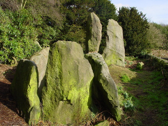 The Bridestones
The walk begins at Timbersbrook, so named after one of the many streams of the area. Site of a former textile mill, the picnic area at the start of the walk was once the site of an old dyeworks. As you walk up the lane towards Gosberryhole Lane you should see water running down the side of the road - numerous springs arise at this level, where the porous gritstone of the Cloud meets the layer of glacial clay that covers much of the Cheshire Plain.
As you climb the Cloud the vegetation changes with bilberry bushes, heather and bracken appearing on the higher ground. Small silver birch and mountain ash are also found on the Cloud. These trees form perches for the songbirds of the area. As you walk through the wood look for goldcrest, jay, chiffchaffs and spotted flycatchers in the summer. Once you emerge onto the heather moor you may see meadow pipits and even cuckoos.
Once on top of the Cloud the views are outstanding. To the left of the ridge is the town of Biddulph, which is north of the Potteries conurbation. To the right of the ridge, the land sweeps down to the Cheshire Plain with the Shropshire Hills beyond. As you turn your gaze to the right you can see the town of Congleton. Further to the right you can see the radio telescope of Jodrell Bank. Power station cooling towers and the buildings of Manchester Airport can also be seen. Looking over the edge of the Cloud to the left of the triangulation pillar you can see the railway viaduct below you which crosses the valley of the River Dane. Beyond the viaduct is Alderley Edge. Prominent hills seen in that direction include Shining Tor, Shutlingsloe of Cheshire and the Roaches and Hen Cloud of Staffordshire.
The return home, after descending the Cloud, includes a visit to the Bridestones, once called the Catstones, a burial chamber probably built during the new stone age. Archaeologists believe that between ten and fifty people were buried here in a communal grave. Having explored the Bridestones and continued to Gosberryhole Lane you make a final detour around a pond. Here you can take a seat and rest while looking across the water.
Acknowledgment: Text derived from the Out and Out Series; Discovering the Countryside on Foot. Pictures courtesy of Wikipedia.


