White Horse of Uffington, Weathercock Hill, Ashdown House and Wayland's Smithy
An ancient horse and country house, both of chalk, and an ancient long barrow
Google Maps Open Source Maps| Statistics and Files | ||
|---|---|---|
| Start: White Horse Car Park | Distance: 8.8 miles (14.2 km) | Climbing: 216 metres |
| Grid Ref: SU 29266 86615 | Time: 4 hours | Rating: Moderate |
| GPX Route File | Google Earth File | White Horse of Uffington |
| Statistics | |
|---|---|
| Start: White Horse Car Park | Distance: 8.8 miles (14.2 km) |
| Climbing: 216 metres | Grid Ref: SU 29266 86615 |
| Time: 4 hours | Rating: Moderate |
| GPX Route File | Google Earth File |
Ordnance Survey Explorer Map (1:25,000)
The Walk:
On the downs above the Vale of the White Horse, ranged along the Ridgeway, there is a collection of ancient sites. This walk visits some of these and heads across rolling, empty downland to an exquisite, little known country house. Whitehorse Hill, where the walk starts, is the highest point on the downs. The White Horse, 376 feet long, that is cut into the slopes, is best seen from below. Close to, it loses all definition. In order to preserve it for future generations, visitors are requested not to walk on the horse.
The viewpoint just above the horse commands a great sweep of the vale and provides the best view of The Manger, a dry valley cut into the scarp slope, and Dragon Hill, a flat topped mound where St George supposedly slew a dragon. The spot where the creatures blood is said to have spilled out is marked by a bare patch where nothing ever grows.
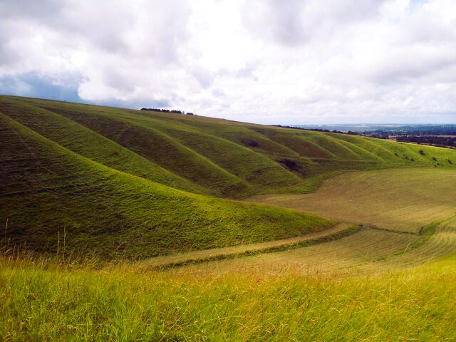 The Manger of Uffington
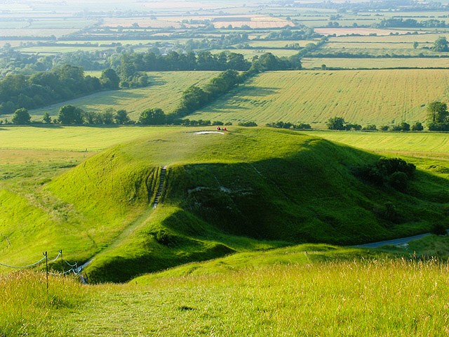 Dragon Hill of Uffington
On the crest of the hill is Uffington Castle, normally classified as an Iron Age hillfort. It commands a fine 360 degree view, but even allowing for the effects of time on the ramparts and ditch, makes an unconvincing fort. This enclosure may have been used in the Iron Age, but it probably predates the period and may be a religious rather than a defensive site.
A gate takes you onto the Ridgeway, which can lay claim to being the oldest pathway still in use in the world. In ancient times, the relatively dry ridge of the downs would have made for much easier going than the damp, heavily wooded low ground to the east. It is now part of the Ridgeway Path, a long distance path that includes part of another ancient trackway, the Icknield Way, and runs for 85 miles from Buckinghamshire to Wiltshire.
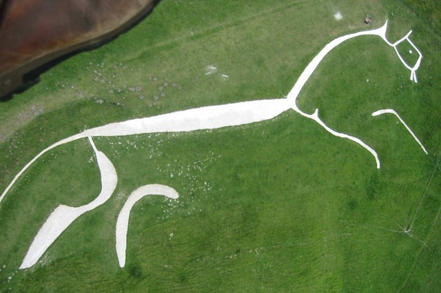 White Horse of Uffington
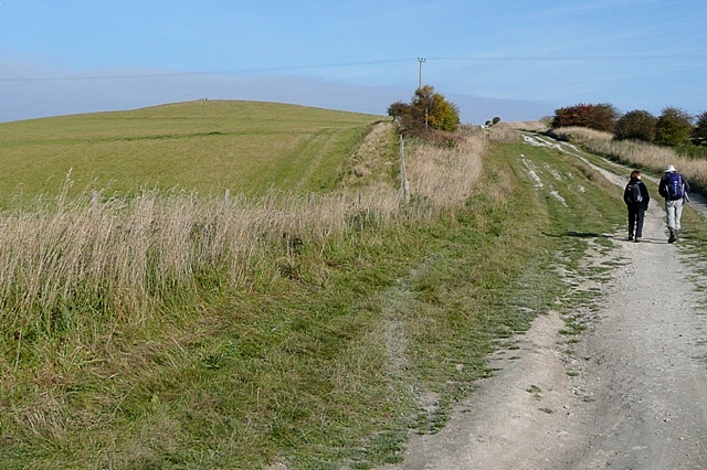 Approaching Weathercock Hill
The route turns off towards the heart of the Lambourne Downs and a landscape of huge, rolling fields, their contours traced by tractor trails through the crops or by the furrows of the plough. Some of the hills are marked by the gallops of the local racing stables. This is empty country with hardly a building to be seen apart from seemingly abandoned barns. As you walk between the fields, you may put up a partridge or startle a lapwing into flight.
The route climbs Weathercock Hill. There used to be a race track on this windy height. What looks to be a shrubby hump to the left of the path conceals the remains of the building where the lathered horses were rubbed down after a race. As you continue across the hill, the 17th century weathercock, from which its name derives, now ignominiously mounted on a telegraph pole, comes into view. Ashdown House, built of chalk with Bath stone dressings, gleams in the sunshine. At dusk, a lamp is lit in the cupola, earning the house the nickname, 'Lighthouse of the Downs'.
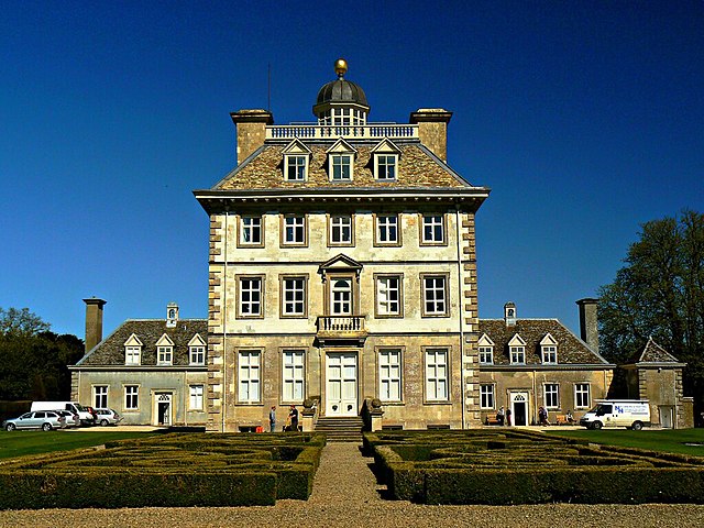 Ashdown House
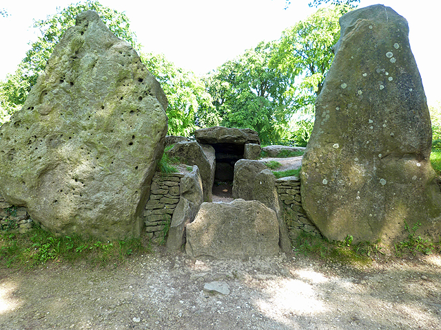 Wayland's Smithy Long Barrow
Like Weathercock Hill, Ashdown House now belongs to the National Trust. It was built in 1660 by Lord Craven. Romantic legend suggests that he intended it for Queen Elizabeth of Bohemia, as a refuge from plague ridden London. However, she died in the capital in 1662. It is more likely that the tall, four-square house, flanked by two detached pavilions was a grand hunting lodge. The cupola and balustraded platform around it would have provided a fine place to view the hunt. The house now contains some of Lord Craven's paintings, mostly portraits dating from the 17th century.
The route goes around the house passing Ashdown Farm, a lovely group of red brick and stone buildings on your left. There is a view of Ashdown House down a once proud avenue of limes. The trees were wrecked by gales in 1990 and were cut back severely in an effort to save them. This proved a success and the limes stand proudly in line once again.
Next you pass Alfred's Castle, a prehistoric site that was much depleted when the castle's stones fortifying its ramparts were removed to be incorporated into the fabric of Ashdown House. The route then goes into Ashton Park, the remains of the woodland that once surrounded the house. Here you may see foxes, squirrels and a host of birds. Fallow deer also live in the mature, broad-leaved woods, though they mostly keep to a private section south of the house. When the park is closed, the route skirts its edge.
A broad grassy swathe - one of four avenues that radiates from the house along the compass points - leads out onto the downland again. Wide tracks lined with beech and birch trees, and bushes of thorn and dog rose, take the route through huge arable fields back to the Ridgeway, and another impressive ancient site. Wayland's Smithy. This is a Stone Age long barrow, shaded by a stand of beech trees and fronted by tall sanding stones.
The passage tomb, now sealed, was built around 3330BC, on the site of an even earlier wooden burial chamber. It was excavated in 1920, any burial goods having been plundered long before, but it still held the remains of at least eight people. The Saxons named it after Wayland the Smith, a legendary wizard who forged armour for the gods. According to legend, whoever left a horse overnight and a coin on the stones, would find the animal shod in the morning.
The route back to Whitehorse Hill follows the Ridgeway. In summer, this last stretch of the walk is lined with flowers and bordered by mature hedges that are haunted by finches and butterflies.
Acknowledgment: Text derived from the Out and Out Series; Discovering the Countryside on Foot. Pictures courtesy of Wikipedia.


