Pakenham and Grimstone End
Windmill Country - Through the Suffolk Fens to visit two spectacular mills
Google Maps Open Source Maps| Statistics and Files | ||
|---|---|---|
| Start: Pakenham | Distance: 6.6 miles (10.6 km) | Climbing: 60 metres |
| Grid Ref: TL 92876 67226 | Time: 3 hours | Rating: Easy |
| GPX Route File | Google Earth File | About Pakenham |
| Statistics | |
|---|---|
| Start: Pakenham | Distance: 6.6 miles (10.6 km) |
| Climbing: 60 metres | Grid Ref: TL 92876 67226 |
| Time: 3 hours | Rating: Easy |
| GPX Route File | Google Earth File |
Ordnance Survey Explorer Map (1:25,000)
The Walk: Pakenham has a unique claim to fame: it is the only village in Britain to have both a watermill and windmill in such good order. See Pakenham Village for the latest news. Although it takes its name from 'Pacca' an Anglo-Saxon settler, the village has a much longer history of occupation, going back beyond the Romans to prehistoric times. The walk takes in the village, woodland, water meadows, shaded lanes, grassy tracks, dense hedgerows, open pastures, quiet flowing streams and still ponds.
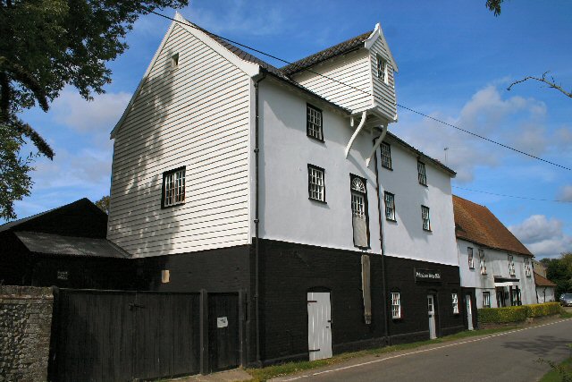 Pakenham Water Mill
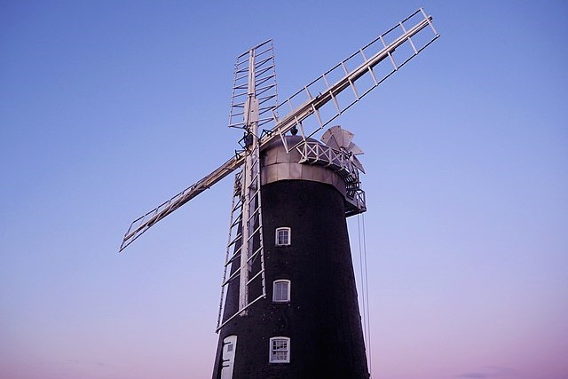 Pakenham Windmill
The walk starts at the parish church of St Mary, which stands above the village on the hill settled by Pacca in the 7th century. This church was built around 1100, with later additions. From the church, the route passes Newe House, a handsome red brick Jacobean mansion built in 1622, and enters Pakenham Wood, a mix of coniferous and deciduous trees and considerably smaller than it once was. Beyond the wood, the path descends gently to the Black Bourn which flows northwards into the Little Ouse.
At Baileypool Bridge, the route leaves the banks of the Black Bourn and follows a quiet road through Grimstone End. Here excavations revealed a Bronze Age barrow which was reused by the Romans then, several centuries later, built over by the Anglo-Saxons. The wasteland just before the mill was part of the site but all evidence has been destroyed by gravel extraction and ploughing. The artifacts are in Ipswich Museum.
The Grimstone End area also boasts Pakenham Watermill which straddles Pakenham Fen Stream, a tributary of Black Bourn. The present building, dating from the late 18th century, replaced a Tudor mill which, in turn, succeeded an earlier mill mentioned in the Domesday Book. Owned today by the Suffolk Building Preservation Trust, a team of dedicated volunteers continues to keep the mill in working order.
Continuing beyond the mill to a meeting of roads we reach the site of a Roman Fort, erected around AD 61 for defence against the rebellious Iceni tribe, who, under their warrior Queen Boudicca, had just sacked Colchester, London and St Albans. From here the walk heads south along a Roman road to reach Pakenham Windmill. It is a grand structure, one of England's finest windmills. Dating back to 1831 it remains a working windmill to this day, and by appointment can be visited.
From the windmill, along Thieves Lane, the route crosses Fulmer Bridge to arrive at Pakenham Fen. The fen remains largely unspoilt and is an attractive to wildlife with many water loving plants predominant. From the fen the walk returns to Packenham by the site of a old chalk pit, now a site of housing. The finale follows the Street back to the start at the church of St Mary
Acknowledgments: Text derived from the Out and Out Series; Discovering the Countryside on Foot. Pictures courtesy of Wikipedia.


