Exploring Lincoln
Around the commons and riverbanks of an historic Roman city
Google Maps Open Source Maps| Statistics and Files | ||
|---|---|---|
| Start: South Park | Distance: 6.1 miles (9.8 km) | Climbing: 126 metres |
| Grid Ref: SK 97956 69983 | Time: 3 hours | Rating: Easy |
| GPX Route File | Google Earth File | About Lincoln |
| Statistics | |
|---|---|
| Start: South Park | Distance: 6.1 miles (9.8 km) |
| Climbing: 126 metres | Grid Ref: SK 97956 69983 |
| Time: 3 hours | Rating: Easy |
| GPX Route File | Google Earth File |
Ordnance Survey Explorer Map (1:25,000)
The Walk:
Dominating the city of Lincoln is its fine cathedral, originally built in the 11th century. This walk leads from South Park across Canwick Hill onto the Cowpaddle - one of three commons in the city - the other two being West Common and South Common, which is also visited on this walk. The commons were originally established as pasture and grazing land and the Domesday Book of 1086 gives the area as some 13.5 carucates (3,600 acres).
From the Cowpaddle leads to the village of Canwick, from where fine views of Lincoln Cathedral can be enjoyed. In Canwick there is a Norman church built on a Roman site. Canwick Hall is the home of the Sibthorpe family. John Sibthorpe was a famous 18th century botanist and politician Charles Sibthorpe sold his land to a railway company for the Lincoln to Grantham line on the condition that trains would never run on a Sunday.
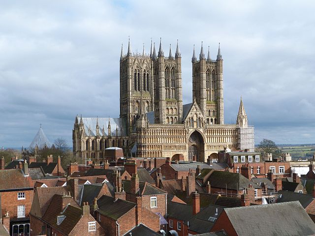 Lincoln Cathedral
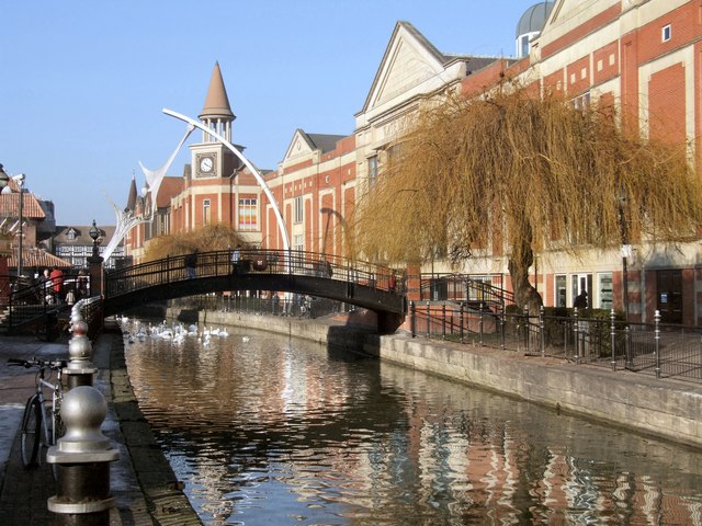 River Witham
From Canwick follow the route leads south-west on a tree lined path beside South Common to cross the A607 leading to Bracebridge Heath and leading to where the path meets the River Witham. Around here, reputedly the oldest part of the city, the Romans kept a garrison from where they controlled most of Eastern England. The river served both to slow down advancing enemies and to provide a link for trade. Roman Lincoln was a fine town with many handsome buildings and public baths. Some parts of the Roman wall around the city are still standing and the Newport Arch survives as the only Roman gateway in this country still used by traffic.
After the Romans left, the Anglo-Saxons and the Danes both influenced the development of the town, but it was eventually the Normans who made Lincoln a very important city. Lincoln Castle was established by William the Conqueror in 1086 and many other fine buildings in the city, well worth a visit, have been erected over the years.
South Common occupies an area of around 220 acres and was originally used as pasture and grazing for the inhabitants of the suburb of Wigford and the villagers of Canwick. The area has never been part of any open field system and has only ever been used for pasture. During the 16th century, in their role as Lords of the Manor, the City Corporation decided to enclose the land. Then later, in the early 1800's the commons were completely closed. When the Lincoln to Honnington railway line was built in the 19th century across the common land the area south of the line was developed for housing. This is now South Park.
From Bracebridge the walk follows the River Witham, which rises near the villages of South and North Witham some ten miles south of Grantham. The river flows north to Lincoln but it is not navigable until it joins Foss Dyke at Brayford Pool. The Foss Dyke was dug by the Romans to link Lincoln with the River Trent. Dating back to 120 AD, it is Britain's oldest artificial waterway. Brayford Pool served as an ancient port. From Lincoln, the River Witham turns south, eventually running through Boston and emptying out into the Wash.
Acknowledgments: Text derived from the Out and Out Series; Discovering the Countryside on Foot. Pictures courtesy of Wikipedia.


