Clare and Cavendish
A walk joining an historic town and picturesque village in rural Suffolk
Google Maps Open Source Maps| Statistics and Files | ||
|---|---|---|
| Start: Clare | Distance: 7.4 miles (11.9 km) | Climbing: 121 metres |
| Grid Ref: TL 77196 45198 | Time: 3 hours | Rating: Easy |
| GPX Route File | Google Earth File | About Clare |
| Statistics | |
|---|---|
| Start: Clare | Distance: 7.4 miles (11.9 km) |
| Climbing: 121 metres | Grid Ref: TL 77196 45198 |
| Time: 3 hours | Rating: Easy |
| GPX Route File | Google Earth File |
Ordnance Survey Explorer Map (1:25,000)
The Walk: The Upper Stour Valley has a quiet charm. Gently undulating fieldscapes with scatterings of trees and woodlands are punctuated by picture postcard villages with half timbered houses, thatched cottages and imposing flint churches - reminders of a past made prosperous by the area's wool trade. This walk visits two of the valley's most attractive centres, Clare - a small market town and its downstream neighbour, Cavendish.
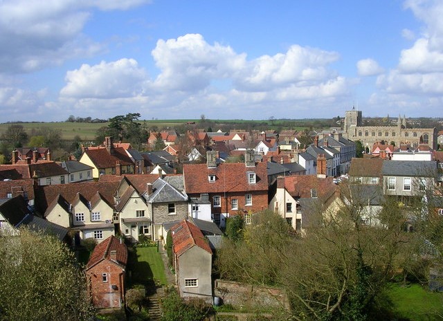 View of Clare from the castle keep
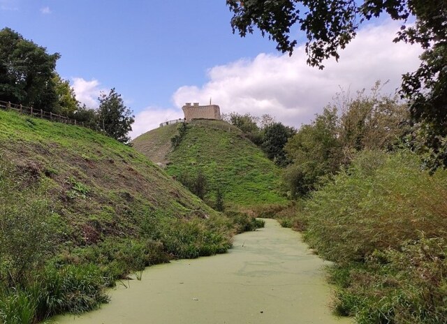 Clare Castle
Clare Castle Country Park, where the walk begins, covers some 23 acres, and roughly corresponds to the Norman castle and its grounds. The building of Clare Castle, on the site of a Saxon fortress, was begun in the late 11th century by Richard fitz Gilbert, a follower of William the Conqueror, who became the first Earl of Clare.
Initially, the castle consisted of an earth mound or motte, around 70 feet (21 metres) high, surmounted by a circular stone keep 29 feet (8.8 metres) high and 54 feet (16.5 metres) in diameter. During the next 200 years, inner and outer baileys were added. The inner bailey contained all the living quarters, the outer bailey was used for keeping livestock, and also served as a general working area. The castle fell into disrepair in the 15th century and today only the motte and the ruined keep and baileys remain.
The country park is also the site of the only railway station in England to have been built inside a castle. The former goods shed now houses the Park Centre, which provides information about the history and wildlife of the park.
The route crosses the railway bridge and makes a brief detour to visit Clare Priory. Founded in 1249, it was the first Augustinian Priory in England. The 14th century house, plus ruined church and cloister, can be viewed from the grounds. The present Roman Catholic Church is in the old infirmary.
Returning to the bridge, you set off along New Cut, an old mill stream diverted from the River Stour. The river itself lies just across the meadow to the south. Never straying far from the river, the route leads to the small town of Cavendish with its picturesque main street.
 Clare Priory
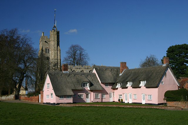 The Pink Cottages and St Mary's Church, Cavendish
Set back behind the duck pond is the Old Rectory, originally a 15th century timber framed farmhouse. Also nearby is the Old Cinema which now houses the Sue Ryder Foundation shop. The well known charity was established in Cavendish. Further along is the spacious green, with attractive houses around it, including a clutch of pink washed thatched alms houses, dating from the 14th century.
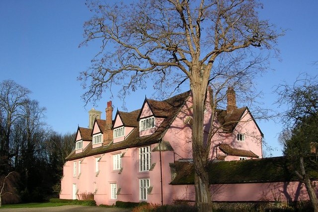
Beyond Cavendish, you pass the Grade II listed Nether Hall, a striking pink washed timber framed house built in the 1500's. Then, you follow the Stour Valley Path across a few fields to Houghton Hall, another Grade II listed building.
On returning into Clare, the walk goes via the Clare Camp Iron Age Fort, a double banked earthwork covering some seven acres, and rejoins Callis Street almost opposite Ship Stores, once a Tudor alehouse and now a Bed and Breakfast.
The centre of Clare is dominated by the 13th century Church of St Peter and St Paul, most of which was rebuilt in the 15th century. Among the church's many notable features, are the brass eagle lectern and the Jacobean carved oak stalls.
To the west of the church, High Street contains various historic buildings, especially the ancient house by the churchyard corner. Formerly the priest's house and now a museum, it dates from 1473, and is remarkable for its superb pargetting - a form of decorative relief plasterwork common in Essex and Suffolk and rarely seen elsewhere.
Acknowledgments: Text derived from the Out and Out Series; Discovering the Countryside on Foot. Pictures courtesy of Wikipedia.


