Hadleigh and Kersey
Weaving around Suffolk - A market town and picturesque village in south Suffolk
Google Maps Open Source Maps| Statistics and Files | ||
|---|---|---|
| Start: Hadleigh | Distance: 5.9 miles (9.5 km) | Climbing: 118 metres |
| Grid Ref: TM 02516 42117 | Time: 2-3 hours | Rating: Easy |
| GPX Route File | Google Earth File | About Hadleigh |
| Statistics | |
|---|---|
| Start: Hadleigh | Distance: 5.9 miles (9.5 km) |
| Climbing: 118 metres | Grid Ref: TM 02516 42117 |
| Time: 2-3 hours | Rating: Easy |
| GPX Route File | Google Earth File |
Ordnance Survey Explorer Map (1:25,000)
The Walk:
During the late Middle Ages, the towns and village of south Suffolk thrived and prospered, thanks to their woollen cloth industry. Their fortunes have since fluctuated, but the legacy of that affluent era lives on in lovely, half timbered houses, cottages and guildhalls, and in handsome churches.
This walk on the fringes of Suffolk's wool country, focuses on Hadleigh and Kersey. Although these two places have a common heritage in wood, Hadleigh is a bustling market town (one of the prettiest and most historic in East Anglia), while Kersey remains a tucked away, picture postcard village.
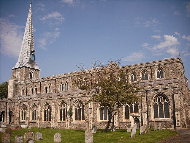 St Mary's Church, Hadleigh
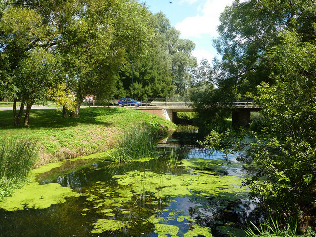 River Brett, Hadleigh
The walk starts and finishes in Hadleigh, attractively sited on the banks of the River Brett, a tributary of the River Stour. From Norman times to the end of the 16th century, Hadleigh grew wealthy, first from wool, then cloth. At the height of its cloth making career in the 1500's, it was the third richest town in Suffolk, after Ipswich and Bury St Edmunds.
The showpiece at the heart of Hadleigh is the group of medieval buildings set round the churchyard: the flint and freestone church, half timbered Guildhall and red-brick Deanery tower. The oldest of these is St Mary's Church, built in the 1200's, then enlarged during the 14th century, and again in the 15th century. The tower, belonging to the original Norman church, supports a lead-covered spire which soars above the town. At the bottom of the spire, there is a clock bell dating from the mid 1300's, one of the oldest in East Anglia. On going into the church, notice that the vaulted ceiling in the porch remains unfinished - almost certainly because the Black Death of 1348 killed off the masons. Outstanding features inside the church include the traceried chancel roof, fine vaulting in the vestry and splendid bench-ends.
The East Anglian martyr-king was decapitated by the Danes under Guthrum in 870 at the Battle of Hoxne. Eight years later, Guthrum himself was defeated by Alfred at the Battle of Edington. To escape execution, he accepted Christianity and was subsequently allowed to remain as ruler of the Eastern counties. He died at Hadleigh in 890 and is buried there, beneath the present church near the 14th century 'Guthrum tomb' in the south aisle, it is said.
Beyond the churchyard stands the 15th century Guildhall, which, for over 300 years, was the hub of Hadleigh's commercial life. The western side of the close is dominated by the Deanery tower, a Tudor Gatehouse built in 1495 by Archdeacon Pykenham as a grand entrance to his new rectory. He died prematurely, before work ever started on the house. Apart from its superb brickwork, the tower is also famous as the birthplace in 1833 of the Oxford movement - a group within the Church of England that rejected the Protestant elements in Anglicanism and eventually developed Anglo-Catholicism.
The churchyard complex lies just off the High Street, a long, wide thoroughfare of enchanted old inns, shops and dwellings, with overhanging eaves and plaster fronts, some of them pargetted. Pargetting, a form of decorative plasterwork, is traditional to Suffolk, as well as parts of Essex and Cambridgeshire. The decoration ranges from elementary combed marks and simple geometric patterns to intricate plant motifs and even murals. Nearby Angel Street, George Street and Benton Street present a delightful kaleidoscope of building styles.
Just to the south of the churchyard stands Toppersfield Hall, under the Normans one of Hadleighs first 'manors'. Nearby is Toppersfield Bridge, the only major medieval bridge still in use in Suffolk.
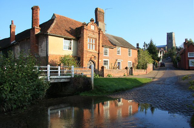 Kersey Ford
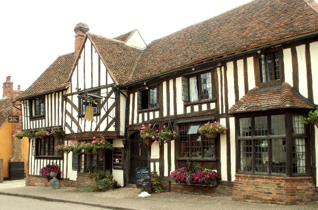 The Bell Inn, Kersey
The village of Kersey is often described as Suffolk's most picturesque village. Its main street - a charm of half timbered, colour washed cottages - plunges down both sides of a steep valley. At the bottom in front of a superb Tudor red-brick house is a ford - across the stream which gives Kersey its name - where ducks have priority over cars.
At the top of the hill on the south side stands Kersey Church - its battlemented flint tower dominating the landscape. The present building largely dates from the 14th and 15th centuries when an extensive reconstruction took place (again interrupted by the Black Death, which devastated the village). But although the exterior has changed little during the last 500 years, the interior was badly damaged at the Reformation, and then, in Victorian times, much restored. Some original features remain however, including elaborate ceiling tracery in the south porch, a delicately carved font and eagle lectern in the nave, and the rood screen with coloured panels in the north aisle. Also in morth aisle is a 12th century font.
The very first church on this spectacular site was Saxon. And the fact that there were two reconstructions so close together indicates Kersey's growing wealth, won from wool.
The Domesday Book shows that sheep farming was already extensive and during the next five centuries cloth making became increasingly important, especially during the 1400's and 1500's. Tradition maintains that the village specialised in a coarse, narrow-ribbed cloth known as Kersey. Shakespeare mentions it several times, but there is doubt as to whether it originated in Kersey.
When the woollen industry collapsed, Kersey relied on agriculture. But last century and this has seen a fall in the population, and those who remain either work locally or are retired.
From Kersey, the route heads back across country to Hadleigh, and its final section follows a pretty woodland path along the River Brett.
Acknowledgments: Text derived from the Out and Out Series; Discovering the Countryside on Foot. Pictures courtesy of Wikipedia.


