Ickburgh, River Wissey, Thetford Forest and Mundford
A walk through Thetford Forest to a typical Breckland village
Google Maps Open Source Maps| Statistics and Files | ||
|---|---|---|
| Start: Ickburgh | Distance: 5.4 miles (8.8 km) | Climbing: 29 metres |
| Grid Ref: TL 80981 94855 | Time: 2-3 hours | Rating: Easy |
| GPX Route File | Google Earth File | About Ickburgh |
| Statistics | |
|---|---|
| Start: Ickburgh | Distance: 5.4 miles (8.8 km) |
| Climbing: 29 metres | Grid Ref: TL 80981 94855 |
| Time: 2-3 hours | Rating: Easy |
| GPX Route File | Google Earth File |
Ordnance Survey Explorer Map (1:25,000)
The Walk:
The walk starts from the village of Ickburgh, passing Manor Farm on the way to the church of St Peters. Notice its massive flint tower and diagonal buttresses - the only remains of the original church. The nave dates from 1865 and was built by Lord Ashburton, then the owner of Lynford Hall.
Unlike many restored churches, it has great charm and even a sense of humour. The Victorian sculptor who crafted its unexpected gargoyles, spiny backed monsters and wry mouthed man plucking at his stringy beard, has given fresh expression to a medieval idiom. Outside, above the east window, the Victorians also embedded a most unusual masons mark - a beer bottle and a mug!
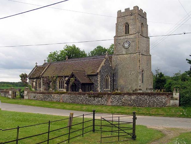 St Peter's Church, Ickburgh
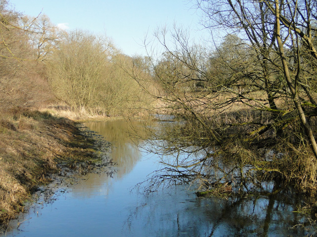 River Wissey
Are you continue from the village up the lane, the twisted shapes of Scots pines come into view along the roadside, stunted by poor growing conditions and tormented by gales. These trees are a common feature of the Breckland landscape, planted to stabilise the soil and improve the habitat for game.
You now enter Thetford Forest, the route skirts the edge of a Ministry of Defence Area, and there are danger signs. The forest is the largest man made woodland in lowland Britain and it occupies an area of 80 square miles (207 square kilometres), all planted since 1922. It is difficult, though, for visitor to appreciate the vastness of the forest as it is so densely wooded and panoramic views are virtually non-existent. The best view is from Gallows Hill, two miles from Thetford along the A134 Munford Road, where it crosses the A11 bypass.
Around a century ago, this view would have been vast open country, dotted with belts of gnarled Scots pines and heather covered sand. Low in rainfall and mostly unsuitable for cultivation, the agricultural depression enabled the state to purchase the land cheaply from owners who had recourse mainly to rabbit farming. In a single lifespan, the forest has matured and is constantly been thinned, harvested and replaced. And this gives employment to several hundred people.
The main crop is Corsican pine, which grows faster, matures earlier, and produces almost double the value of timber as the native Scots pine. Broad leaf species have been planted too, along the roadside within the forest, with the double purpose of breaking up the blocks of conifers and hence limiting the spread of fire.
The wildlife in the area has changed greatly since the first plantings took place, and the forest today is one of the last habitats of the red squirrel in eastern England. Red, roe, fallow and muuntjac deer roam freely. Curlew, redstart and red-backed shrike inhabit the forest edges and adjoining heathland and nightjars visit from mid May to August.
As you follow the path past Buckingham Mill, the red topped posts mark it as a Forestry Commission long distance footpath, its full extent from High Ash to West Stow is 23 miles (37 kilometres).
 Thetford Forest
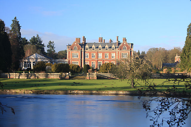 Lynford Hall
The path leads onto an arboretum where there is a site laid out with picnic tables. It is often possible to have the whole place to oneself. The path continues downhill to a bridge offering fine views of Lynford Hall, the third hall to be built on the site. In its pastoral setting, on the other side of this branch of the River Wissey. Work began on this version in 1857 when its owner, Lyne Stephens, commissioned William Burn, an eminent architect of the day.
The result is a 120 room neo-Jacobean hall of red brick with stone facings, that was to become the premier sporting estate in Norfolk. It was particularly acclaimed throughout Britain for the high quality of its partridge shooting, and it had a game bag of 33,000 that attracted members of the royal family, including the Duke of Windsor. 40,000 rabbits were also dispatched annually to the London market and Brandon fur factories from the estate. It was the last home, too, of the indigenous great bustard in England, now sadly extinct.
Two World Wars, occupation by the military, and a disastrous fire, combined with the change in social and economic conditions, meant that the estate never recovered its former greatness. It was taken over in 1947 by the Forestry Commission as a training school for foresters.
The walk passes the end of Lynford Lake on its way back to the village of Mundford with its well tended village green. The cottages in Mundford are a happy mixture of chalk, brick and flint, with thatched, pantiled and slate roofs.
The Church of St Leonard's is of flint and tiled with a slender spire. Inside it has been well restored and the chancel is especially attractive, divided from the nave by a beautiful rood screen and loft.
Returning to the starting point, you cross the River Wissey again, over a bridge where stood a lepers hospital, from the reign of Edward I until the Reformation. The religious community maintained it by raising alms from the ferry and its toll.
Acknowledgments: Text derived from the Out and Out Series; Discovering the Countryside on Foot. Pictures courtesy of Wikipedia.


