Wimpole Hall, Wimpole Park and Orwell
Along the Mare Way - A walk along a ridge with wide views of rolling countryside
Google Maps Open Source Maps| Statistics and Files | ||
|---|---|---|
| Start: Car Park | Distance: 7.8 miles (12.6 km) | Climbing: 130 metres |
| Grid Ref: TL 33810 50933 | Time: 3 hours | Rating: Easy |
| GPX Route File | Google Earth File | About Wimpole Hall |
| Statistics | |
|---|---|
| Start: Car Park | Distance: 7.8 miles (12.6 km) |
| Climbing: 130 metres | Grid Ref: TL 33810 50933 |
| Time: 3 hours | Rating: Easy |
| GPX Route File | Google Earth File |
Ordnance Survey Explorer Map (1:25,000)
The Walk:
Wimpole Hall, on which this walk centres, is owned by the National Trust, and is the largest and most impressive mansion in Cambridgeshire. The estate was left to the National Trust in 1976 by Mrs Elsie Banbridge, the daughter of Rudyard Kipling. The hall is sat in a vast area of superb parkland, which makes for a really excellent walking.
This area of Cambridgeshire is undulating and the walk provides some wide-ranging views of the surrounding countryside - in fact this is one of the very few places in the country where you can walk along a ridge with good views on both sides. There is also an opportunity to visit the nearby village of Orwell.
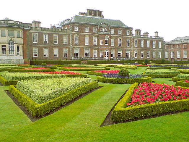 Wimpole Hall
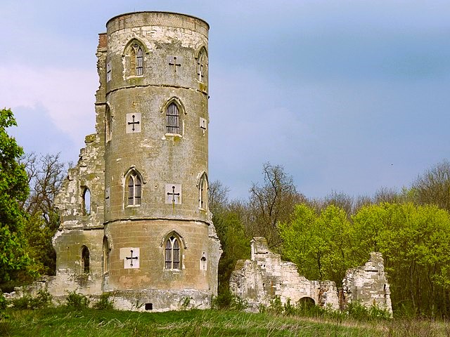 Wimpole Folly
The walk starts near the stables, which were built in 1851. These have been renovated and now house the ticket office, shop, refreshments bar and toilets. The hall was originally built in about 1640 by Sir Thomas Chicheley, but has evolved over the years under varying ownership. The principal owners were the 2nd Earl of Radnor, the Earl of Oxford and the four Earls of Hardwicke, who owned the estate between 1740 and 1873. The hall contains many finely decorated rooms, a chapel and unusual sunken plunge bath, and a fine collection of books, including some rare editions of Kipling.
Away from the front of the hall stretches the enormous South Avenue. This was planted in the 1720's by Charles Bridgeman for the Earl of Oxford, and extends for over two miles. It was originally made up of elms, but these succumbed to Dutch Elm Disease in the 1970's, and the avenues have since been replanted with limes.
After passing the hall, the walk passes a section of the ha-ha. This is a ditch which separated the formal gardens from the park, and was used rather than a hedge or fence, so that the view would not be spoiled. As you go up the hill, look at the parkland to the left, where you can see the distinct ridges and furrows of the Saxon open field method of cultivation. The Wimpole ridges are particularly prominent because hardly any further cultivation has occurred since the fields fell into disuse. As you continue up the hill, there is a good view to the south.
After turning the corner at the top of the hill, you pass the mound on which the estate windmill stood, and next reach the Fosse, a ditch which separates the deer park from the gardens of the Earl of Radnor. The Lake is the only one remaining of a series of three constructed by Capability Brown to provide a feature in the park. The others are now silted up. The Chinese Bridge has been rebuilt by the National Trust.
Although the folly may look like a ruined castle, it was, in fact built exactly as you see it today by Capability Brown for the 2nd Earl of Hardwicke in about 1770. His intention was to create a visual effect from the back windows of the Hall. In the early part of this century, the tower part was occupied for a number of years by the head gamekeeper.
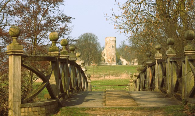 Chinese Bridge, Wimpole Park
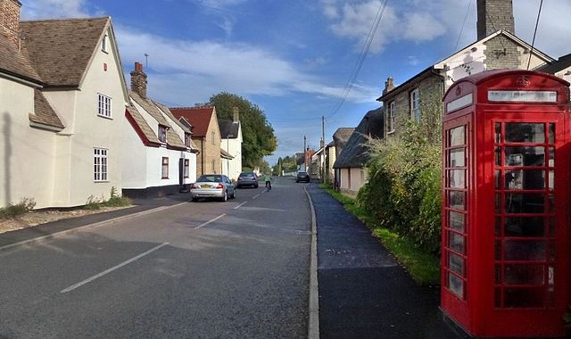 Orwell High Street
Just passed the folly is one of the viewpoints. In the foreground the fields fall away to the buildings of Home Farm, in the middle is a level stretch of the upper Cam Valley, and in the distance the high ground of the Hertfordshire boundary near Royston - the very essence of an English rural landscape. The next feature is the Mare Way, which stretches for about 2.5 miles along a ridge. It was probably part of an old packhorse route, along which there is a great view of the Gog Magog Hills to enjoy.
Continuing along the Mare Way, it is here that you can appreciate the true benefits of the ridge walk, with its wide views on either side. There is an especially good view to the west as you start to descend the hill, leading towards the village of Orwell.
The first feature you reach in Orwell is the clunch pit, from the top of which there is an extensive view to the south. Clunch is a hard form of chalk, which was used locally for building purposes, and probably many of the older houses in the village would have been built from it. Now disused, the pit is owned by the village, and has become home to many varieties of chalk loving plants that have taken root there.
When you reach the road, you see the other main feature of the village - a thatched wall. This type of wall is very rare; there are very few anywhere in the entire country. Further along the road, the church of St Andrew's has one of the oldest working public clocks in the country, dating from 1616. It was moved from Trinity College, Cambridge, in around 1740.
The route next goes along field edges, across meadows, where there may be cattle, and finally out to the old estate woodyard and blacksmith's shop. Next, the final stretch of the walk takes you across the park and brings you back to the car park and the stables.
Acknowledgments: Text derived from the Out and Out Series; Discovering the Countryside on Foot. Pictures courtesy of Wikipedia.


