A walk around Boston
A ramble around a historic town full of fascinating buildings
Google Maps Open Source Maps| Statistics and Files | ||
|---|---|---|
| Start: Tunnard Street | Distance: 2.9 miles (4.7 km) | Climbing: 10 metres |
| Grid Ref: TF 32582 44551 | Time: 1-2 hours | Rating: Easy |
| GPX Route File | Google Earth File | About Boston |
| Statistics | |
|---|---|
| Start: Tunnard Street | Distance: 2.9 miles (4.7 km) |
| Climbing: 10 metres | Grid Ref: TF 32582 44551 |
| Time: 1-2 hours | Rating: Easy |
| GPX Route File | Google Earth File |
Ordnance Survey Explorer Map (1:25,000)
The Walk:
The ancient market town of Boston, on the River Witham, was a well established port by the time of the Norman Conquest. By the end of the 13th century, it was second only to London. At this time, there was a thriving trade route across the North Sea. Merchants came from all over to buy wool, salt and grain, and brought with them timber wine and spices.
Boston was the centre of the wool trade and the town's fair was an international event. The notable Hanseatic merchants from Germany established a guildhouse in the town. When the wool trade slumped, Boston went into a sharp decline. The river silted up and the corporation petitioned that 'their borough might be put among the decayed towns'.
However, in 1766 the Grand Sluce, a sea lock, was built and river improvements began. Trade started up again. In 1884 a dock basin was opened up, and Boston is Lincolnshire principal port to this day. All along the Witham, from the sluice to the Wash, fishing boats and other seagoing vessels are moored.
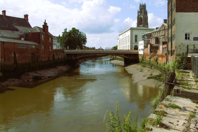 River Witham, Boston
 Maud Foster Windmill, Boston
Beside the river stands Boston's most famous landmark and the focal point of the town, St Botolph's Church. It was begun in 13O9. The octagonal tower, known as Boston Stump, was added in 1460. At 272 feet (83 metres), it is the tallest church tower in England. The 16th century lantern on top acted as a beacon for travellers on land and sea. Visitors can climb the tower for a marvellous view over a third of the county, including Lincoln Cathedral, 32 miles (51 kilometres) to the north-west.
Merchant guilds paid for the church, the interior of which is of cathedral-like proportions, with a high embossed roof supported by slender quotrafoil columns. The Jacobean oak pulpit was used by the nonconformist vicar John Cotton, who emigrated to Boston, Massachusetts and became the first minister of the Christian church over there. Almost all the choir stalls in St Botolph's are original and have highly carved misericords showing quaint subjects such as a bear playing the organ.
In front of the church is a statue of Herbert Ingram (1811-60), an MP from Boston and the founder of the Illustrated London News. He faces the market place where an open air market with over 160 stalls is held on Wednesdays and Saturdays.
The walk continues past Town Bridge into South Street, where many of Boston's best buildings are. Shopfriars Hall takes its name from the site of the old friary, where it stands. Despite its authentic appearance, it is a Victorian copy of a 15th century half-timbered building with a decorative plasterwork.
In the early 14th century, Boston had four friaries. Little remains save for Blackfriars Hall, now an arts centre. The Dominicans or Black Friars were the first to settle in Boston; the centre's facade is thought to have been their refractory wall.
Custom House Quay, formerly known as Packhouse Quay, was the busy trading centre of the old port, which reached as far as St Botolph's. Customs House was built in 1725 at a cost of £365, and is a fine example of 18th-century town architecture, displaying an impressive royal coat of arms over the entrance. It stands, partly, on the site of an old Dominican Friary and replaced an earlier Custom House purchased by the Crown in 1633.
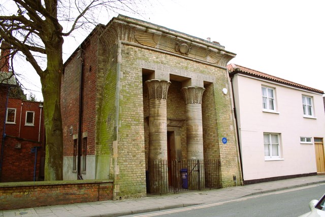 Boston Masonic Lodge
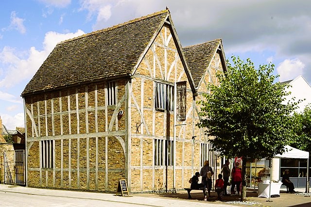 Old Pescod Hall, Boston
Boston's history can best be understood by a visit to the Guildhall Museum. Built in 1450, the Guildhall became the town hall a century later, and remained so for the next 300 years. The most interesting rooms are the prison cells where the Pilgrim Fathers were imprisoned and the courtroom where they were tried in 16 or 7. The latter houses a display of John Foxe, the Protestant reformer who wrote Foxe's Book of Martyrs.
Next door in South Square is Fydell House, a superb Georgian townhouse, built by a wealthy wine merchant who was three times mayor of Boston. It became the home of many generations of his family.
The route heads east to continue along the Maud Foster Drain, named for a 16th century local landowner. It is part of a network of waterways built to drain the flat fenland, and to provide a defence against the encroachment of the North Sea. The drains are navigable between May and September. On the drain is another skyline landmark, Maud Foster Windmill. With its seven floors, it is Britain's tallest working windmill. Its five whirling sails and ogee cap dominate the landscape.
Thomas and Isaac Reckitt built the cornmill in 1819. The brothers went bankrupt in the 1830's. Isaac later left for Hull where he founded the business that was to make him a household name. Maud Foster is the only one of Boston's several windmills to survive. It has been restored by the Waterfield family and is open to the public, selling stone ground flour from a wholemeal shop on the premises.
You walk back into the medieval heart of Boston, and the network of lanes leading off Market Place. At the top of Mitre Lane is a lovely 15th century timber framed building, Pescod Hall. From Market Place, the route goes along the intriguingly named Wormgate to return to the start.
Acknowledgments: Text derived from the Out and Out Series; Discovering the Countryside on Foot. Pictures courtesy of Wikipedia.


