A walk around Norwich
A walk through one of Britain's finest medieval cities
Google Maps Open Source Maps| Statistics and Files | ||
|---|---|---|
| Start: Norwich Viewing Point | Distance: 3.6 miles (5.8 km) | Climbing: 91 metres |
| Grid Ref: TG 24382 09367 | Time: 1-2 hours | Rating: Easy |
| GPX Route File | Google Earth File | About Norwich |
| Statistics | |
|---|---|
| Start: Norwich Viewing Point | Distance: 3.6 miles (5.8 km) |
| Climbing: 91 metres | Grid Ref: TG 24382 09367 |
| Time: 1-2 hours | Rating: Easy |
| GPX Route File | Google Earth File |
Ordnance Survey Explorer Map (1:25,000)
The Walk:
Around 350 years ago, Norwich, one of England's largest provincial cities, was described as 'either a city in a orchard or an orchard in a city', so equally were the houses and trees blended in it. No industrial haze disturbed the view, nothing moved faster than a galloping horse or a passing swift, and no noise came from the sky.
Today, Norwich remains a treasury of medieval Britain, while providing services for an expanding industrial region. Remarkably, it is still a pleasant city in which to walk; its field paths, riverside walks and pedestrianised streets waiting to be explored. This walk covers the main centres of interest while avoiding almost all of the traffic.
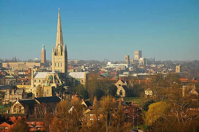 City skyline from Norwich Viewing Point
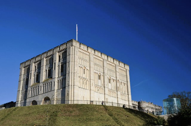 Norwich Castle
The viewpoint on St James Hill is a fine spot from which to view the city, and it also dispels the notion that all East Anglia is flat. It will be seen that Norwich - really an agglomeration of several medieval villages - straddles the River Wensum while tucked within a wide bend of the River Yare. The magnificent panorama ahead is dominated by Norwich Cathedral and, appearing almost behind its spire, the green patina top bell-tower of the city hall. To the left, the panelled tower of St Peter Mancroft, a true city church, rises elegantly, while to the right and nearer the horizon stands the square towered bulk of St John's the Baptist Catholic Cathedral.
Bishop Bridge, built in 1340, is the only surviving medieval bridge in the city. Nearby is Pulls Ferry, dating from the reign of Elizabeth I. A plaque under the archway and a notice board on the river bank explain its significance. From here beautiful houses frame a quiet back street, once the canal along which building materials were hauled to the cathedral. Set serenely in a slight hollow, Lower Close reveals the magnificent southern elevation of the cathedral, soaring cliff like above neat lawns and the largest cloisters in England. This cathedral must have one of the cleanest exteriors in the land, its external stonework revealing rich colouring, enhanced by a pastel clock face over the entrance.
Leave by the west door and past the precincts of Upper Close, where Admiral Nelson attended school, before passing through the gateway, built almost six centuries ago by Sir Thomas Erpingham, Knight at Agincourt, and characterised in Shakespeare's play, Henry V.
Elm Hill is a restored medieval street, its cobbled surface rising steadily between irregularly placed frontages of vernacular architecture. St Andrew's and Blackfriars were once vast monastery churches. Nearby, in Magdalen Street, is Gurney Court, once the home of Elizabeth Fry (1780-1845), Quaker and prison reformer.
Bridewell Alley houses the Bridewell Museum, which is packed with local artefacts. Beyond, at number three, is Colman's Mustard Shop, where beautifully displayed and presented examples of this local product make useful souvenirs.
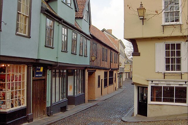 Elm Hill, Norwich
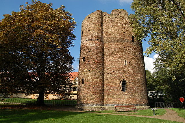 Cow Tower, Norwich
Notice the flush flintwork of the Guildhall. Close by, the largest open air market in England is fronted by St Peter Mancroft and its clear glass clerestory windows. St Peter's, one of the many city churches, is much used, polished and lovingly upkept by the people of Norwich. Its hammer beam roof is masked by false vaulting below which the east window filters sunlight through 15th century Norwich Glass.
With its magnificent external decoration, Norwich Castle dates from 1160, and is an outstanding example of Norman military architecture. Today, it houses an equally outstanding museum and art gallery with, in particular, an excellent display of landscape pictures by the Norwich School of Painters. These pictures were avidly collected by wealthy local families in the early 19th century.
Two squat towers above Castle Gardens mark the spot where, in days gone by, convicted criminals were publicly executed, to the huge delight of crowds in the cattle market below. Robert Kett, who led a peasant's revolt in 1549 died here, hanged from the castle walls.
The medieval flush flint archway of Ethelbert Gate takes you out of the rush of the city, into the serenity of Cathedral Close, which contains beautiful houses, some Georgian, some earlier, several of which have now been turned into offices. Just past the cathedral door lies the grave of Edith Cavell, a heroic nurse who was executed by the Germans in 1915 for helping British prisoners of war escape.
The flint tower of the parish church of St Helen marks the entrance to the Great Hospital, founded in 1249, and still being built. Access to the church is through the gardens, via a cloister, where inquiries at reasonable hours will produce a key. St Helens was once larger, but during the Reformation, much of it was divided into communal wards where the sick and elderly took shelter.
From St Helen, a final stroll along the banks of the River Wensum leads back to the start of the walk. On this final stretch along the riverbank, you will notice an imposing tower by the waterside. This is the Cow Tower, a 14th century artillery tower, strategically placed to defend the city from any potential invasion.
Acknowledgments: Text derived from the Out and Out Series; Discovering the Countryside on Foot. Pictures courtesy of Wikipedia.


