Cambridge, Colleges and River Cam
Walking around a famous and historic university city
Google Maps Open Source Maps| Statistics and Files | ||
|---|---|---|
| Start: Guildhall | Distance: 5.0 miles (8.0 km) | Climbing: 11 metres |
| Grid Ref: TL 44887 58385 | Time: 2-3 hours | Rating: Easy |
| GPX Route File | Google Earth File | About Cambridge |
| Statistics | |
|---|---|
| Start: Guildhall | Distance: 5.0 miles (8.0 km) |
| Climbing: 11 metres | Grid Ref: TL 44887 58385 |
| Time: 2-3 hours | Rating: Easy |
| GPX Route File | Google Earth File |
Ordnance Survey Explorer Map (1:25,000)
The Walk:
The mellow stone and brick buildings of the university colleges, with their rolling lawns and weeping willows on the river banks, provide the setting for this walk through Cambridge, one of England top tourist attractions.
Cambridge was an important market town long before the universities were established. The earliest known settlement in this area dates from Roman times, and what today is the Market Place was once the site of Saxon settlements. In 1068, shortly after their famous conquest, the Normans built a castle near the old Roman site. According to the Domesday Book, there were about 400 houses in Cambridge by 1086.
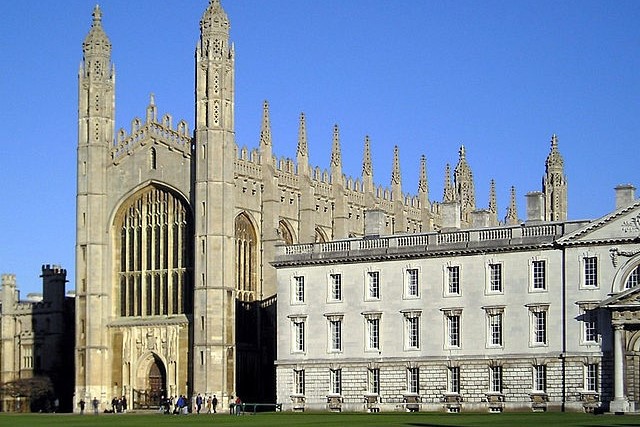 Kings College Chapel
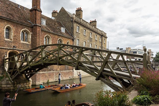 Mathematical Bridge, Cambridge
Cambridge first came to prominence in 1209, when a number of scholars moved here from Oxford. It soon became a centre for learning and by the mid 13th century Cambridge was firmly established and recognised as a university city with its own chancellor. The first college, Peterhouse, was founded in 1284 by the Bishop of Ely and, in the next two centuries, eleven more colleges were founded. Today, the university has more than 10,000 undergraduates and some thirty colleges.
The walk starts at the Guildhall opposite the colourful stalls of the marketplace, and soon you pass the University Church of Great St Mary's. Just across King's Parade are the administrative headquarters of the university.
There are three colleges on King's Parade. The first on the route is King's, founded in 1440 and housing a magnificent pinnacled chapel. This is sometimes open to the public and well worth a visit. Next is the early red brick of St Catharine's, built in 1473 and, over the road, the grey stone of Corpus Christi, which predates it by over a century.
Down by the River Cam is Queen's College, founded in 1448. The famous Mathematical Bridge connects the two parts of the college. Originally constructed in 1749, it was rebuilt in 19O2.
Soon, you come to one of the aesthetic highlights of the walk, an area known as 'The Backs', where trees and graceful lawns slope gently down to the river behind east facing college buildings.
At Garret Hostel Bridge, pause to look to the north to Trinity Bridge, framed in weeping willows, and to the south, to Clare and King's. You may even be tempted to try your hand at punting. There are several points along the river from which you may embark. Just over the bridge stands Trinity Hall, dating from 1350, whose gardens are famed for their herbaceous borders.
The Church of the Holy Sepulchre, just beyond Trinity and St John's, Cambridge's two largest college, is something of a rarity. It is one of only four round churches in the entire country.
Magdalene (pronounced 'maudlin') Bridge stands near the old Roman site, and is the bridge from which the city takes its name.
At St Giles Church, it is possible to take rubbings of the fine brasses found within, while nearby, housed in what was formerly the White Horse Inn, is an interesting Folk Museum.
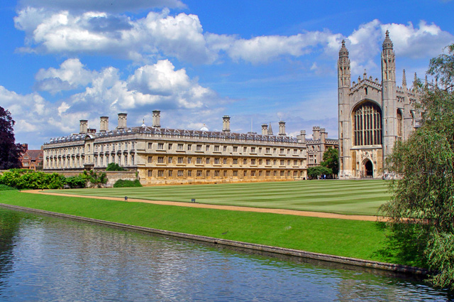 Clare College
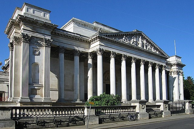 Fitzwilliam Museum
As you walk alongside the river, you skirt the edge of Midsummer Common, where one of the largest fairs in the country has been held since the Middle Ages. Soon you cross Christ's Pieces, a delightful small green area with a wonderful display of flower beds in spring and summer. Parker's Piece is larger, and accommodate several cricket and hockey pitches.
On Lensfield Road is the Scott Polar Research Institute, which was founded as a memorial to Captain Scott and his companions.
Further along the road is Hobson's Conduit, originally located in the Market Place, and the outlet for the city centre's first drinking water supply. The water came from springs about three miles away. Hobson, a carrier, was one of several people involved in the project, and is immortalised in the phrase 'Hobson's Choice', meaning no choice at all. He had about 40 horses for hire, but refused to let out any horse except the one which had rested for longest.
Old Addenbrooke's Hospital, no longer used for its original purpose, was founded with money left by John Addenbrooke, a graduate of St Catherine's College, and opened in 1766. The Fitzwilliam Museum, one of the best outside London, was founded in 1816 with a bequest from the 7th Viscount Fitzwilliam. It houses several important collections. Just past the museum is Peterhouse, the oldest college. On the other side of the road is Pembroke, dating from 1347, its chapel was the first building designed by Sir Christopher Wren.
Further on in Free School Lane, the old Cavendish Laboratory was founded by the 7th Duke of Devonshire, and it was here that Ernest Rutherford did his early work on splitting the atom and other experiments which led to the development of nuclear physics.
The Saxon Tower of St Bene't's Church (the name is an abbreviation of St Benedict's), is the oldest surviving building in the city and was probably built in about 1025. The main church building is of a somewhat later date.
Acknowledgments: Text derived from the Out and Out Series; Discovering the Countryside on Foot. Pictures courtesy of Wikipedia.


