Shotley, Erwarton Hall, Erwarton Bay and Shotley Gate
Wading birds and fine buildings on a little known peninsula
Google Maps Open Source Maps| Statistics and Files | ||
|---|---|---|
| Start: Shotley | Distance: 6.5 miles (10.5 km) | Climbing: 71 metres |
| Grid Ref: TM 23526 35094 | Time: 3 hours | Rating: Easy |
| GPX Route File | Google Earth File | Shotley Peninsula |
| Statistics | |
|---|---|
| Start: Shotley | Distance: 6.5 miles (10.5 km) |
| Climbing: 71 metres | Grid Ref: TM 23526 35094 |
| Time: 3 hours | Rating: Easy |
| GPX Route File | Google Earth File |
Ordnance Survey Explorer Map (1:25,000)
The Walk: The vast majority of passengers leaving England by the East Coast route go from Harwich or Felixstowe. Separating these two industrial ports is a tongue of land (peninsula) bounded by the estuaries of the River Orwell and the River Stour. This walk explores the tip of that tongue.
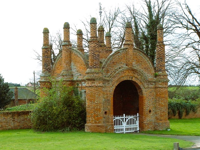 Erwarton Hall Gatehouse
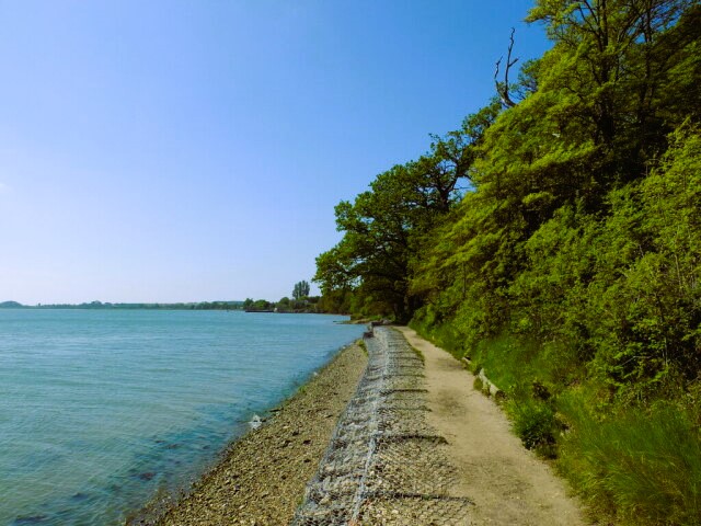 Erwarton Bay on the River Stour
After parking up in the car park of Shotley Village Hall, you follow the quiet road out of the village to arrive at the Gatehouse of Erwarton Hall. This is a curious red brick gatehouse with tunnel vaulting and table like turrets. It may have simply been a joke or one of England's oldest surviving follies. It predates the impressive Erwarton Hall by a quarter of a century.
The hall was built in 1575 for Sir Philip Parker as a replacement for a previous building owned by an uncle of Anne Boleyn. Henry VIII reputedly came here, and after Anne's execution, her heart was removed and buried in St Mary's Church, half a mile away, which is visited later on in the walk.
Today's building is one of the first brick-built manor houses in Suffolk, and is everything that a manor house should be. Its facade, though much altered, is still recognisably Elizabethan, with bricks laid in English bond and with mullioned and transomed windows. It sits serenely in well manicured, stepped lawns, with shaded views of the River Stour.
The path winds under more ancient chestnut trees, and round the end of a lake, before heading over open fields towards the estuary. If you go quietly, you might see a little tern, a hen Harrier or a ruff.
When you get to the high watermark, you turn left to follow a path around the curve of Erwarton Bay. This is a good spot for viewing black tailed godwits, overwintering among more common waders such as grey and green plovers, oystercatchers and redshanks.
On the opposite shore is Parkstone Quay, serving the adjacent ancient town and port of Harwich. Daniel Defoe wrote in 1746 that "Harwich is a town of hurry and business. Not much of gaiety and pleasure", and there is still plenty of bustle there to day in marked contrast to the timeless fields and marshes of this walk.
 Shotley Gate
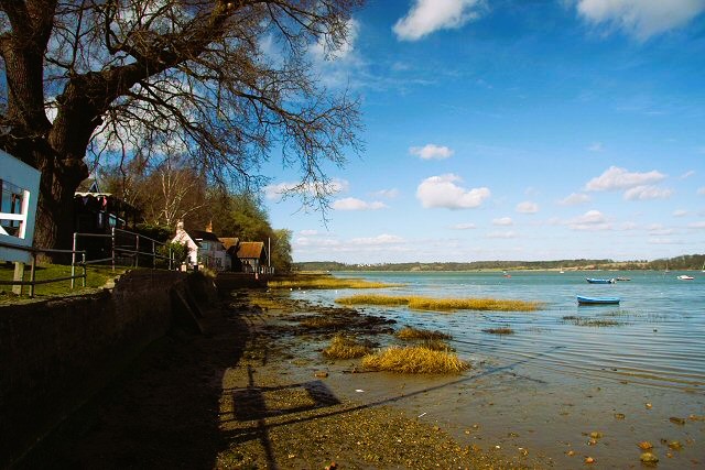 River Orwell at Shotley Gate
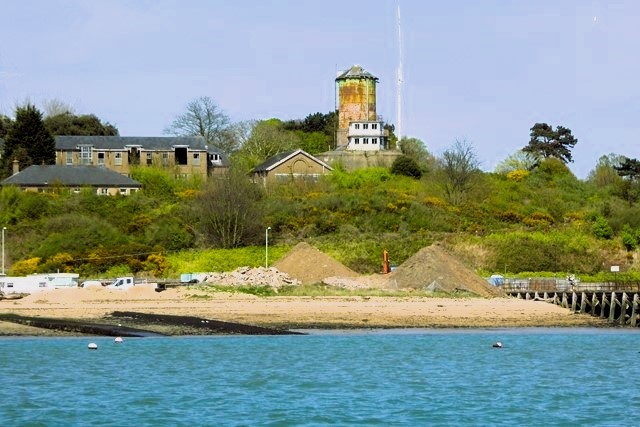
Ahead is the small town of Shotley Gate. Here is HMS Ganges, one of the Royal Navy's shore establishments, which was founded in 1904 to train cadets. Part of this training involved a ritual 'manning of the mast' of the 143 foot Cordelia, which is still set up on the parade ground. A button boy was required to stand to attention and, undoubtedly, salute from a circular platform only 11 inches in diameter at the top of the mast. The site is now HMS Ganges Museum.
From here, the path flanks the spick-and-span yachting marina. Beyond it, you have your first clear view of the North Sea. You follow the edge of the River Orwell, walking past a martello tower and then out into open countryside.
The marsh here is an important breeding ground for a long list of birds. Its wide flats perimeter dykes and reed beds provide sometimes permanent, often only temporary, refuge for warblers, reed bunting, tufted duck, snipe, wigeon, teal and yellow wagtails. The larger Brent goose and Bewicks and whooper swans can also be seen, as well as the day flying short-eared owl.
Sea bass, grey mullet, golden mullet, sea trout and eels all pass through these waters, and plants such as sea lavender, cord grass, mudwort and stalked sea purslane, rare in British estuaries, grow here.
Inland, to your left, is the squat shape of St Mary's, the parish church of Shotley, an awkward building that crouches on a slight eminence just outside the village. Its west tower is no higher than the nave, which gave rise to the sailor's rhyme:
"Shotley church without a steeple
Drunken parson, wicked people".
You head inland to the church at Shotley End. On closer inspection of St Mary's, there is an excellent 15th century clerestory window and a double hammer-beam roof of the same date in the nave, while the chancel dates from the reign of George II (1727-60) and is classical in style, with delicate plaster cherubs floating in the coved ceiling.
From St Mary's the walk continues eastwards along the road to Shotley Hall, a striking black and white timbered house mansion. From here a path leaves the road heading due south across a couple of fields back to Shotley and the starting point of the walk.
Acknowledgments: Text derived from the Out and Out Series; Discovering the Countryside on Foot. Pictures courtesy of Wikipedia.


