Brandon, Little Ouse Path and Brandon Country Park
A ramble through the industrial past in a Breckland town
Google Maps Open Source Maps| Statistics and Files | ||
|---|---|---|
| Start: Brandon | Distance: 5.1 miles (8.2 km) | Climbing: 34 metres |
| Grid Ref: TL 78313 87172 | Time: 2-3 hours | Rating: Easy |
| GPX Route File | Google Earth File | About Brandon |
| Statistics | |
|---|---|
| Start: Brandon | Distance: 5.1 miles (8.2 km) |
| Climbing: 34 metres | Grid Ref: TL 78313 87172 |
| Time: 2-3 hours | Rating: Easy |
| GPX Route File | Google Earth File |
Ordnance Survey Explorer Map (1:25,000)
The Walk: This walk begins from Brandon Railway Station - if it is still there. SAVE Britain’s Heritage has been campaigning to preserve the disused station buildings, which are boarded up. The station was visited by King George VI in 1945 and used as a location for TV sitcom Dad’s Army in 1968.
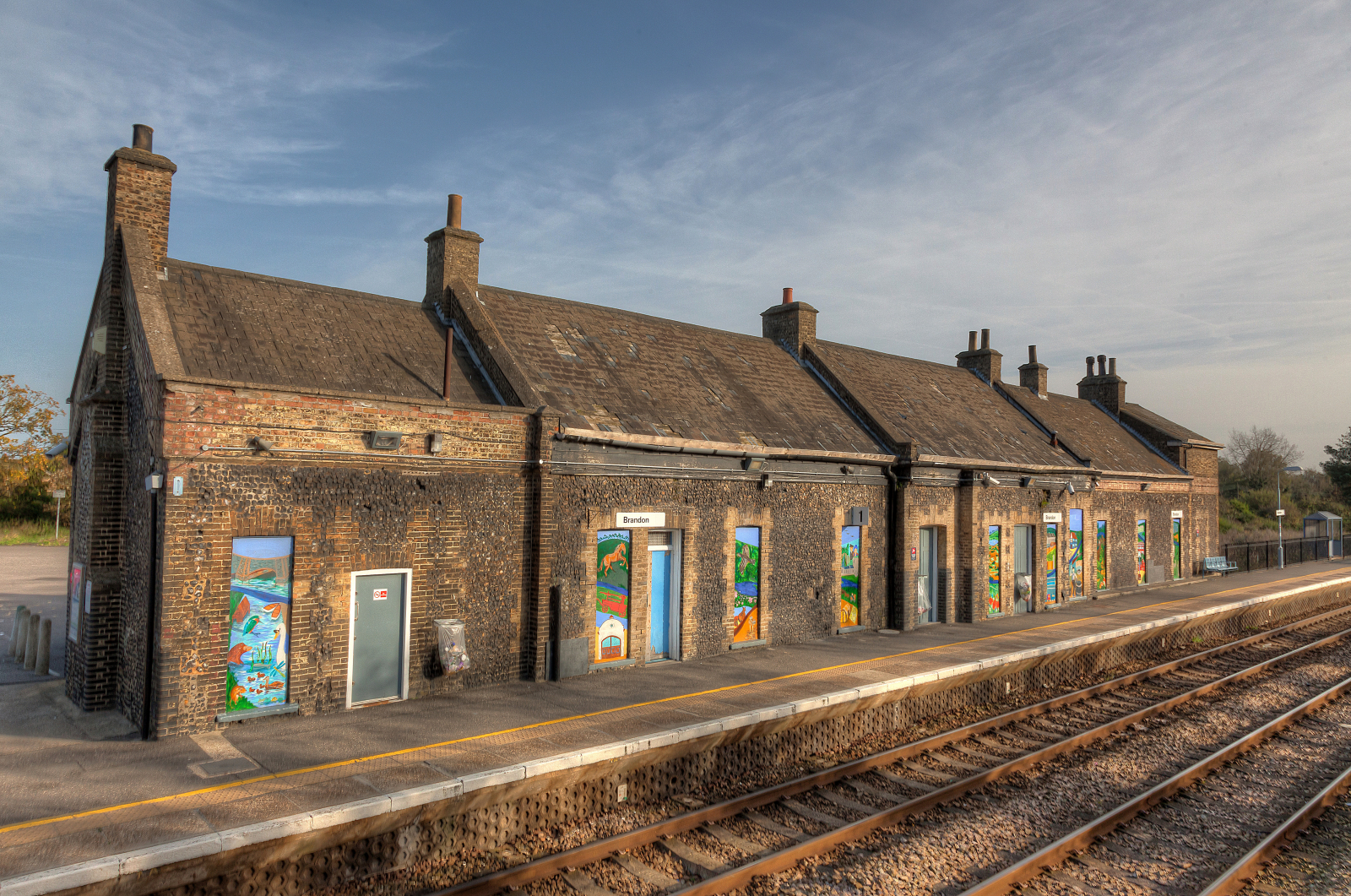 Brandon Railway Station
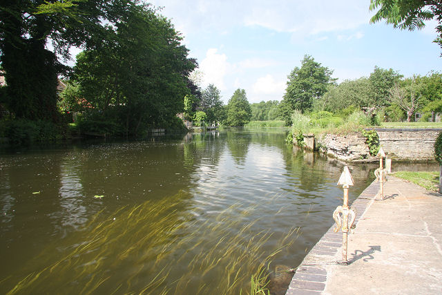 River Little Ouse at Brandon
West of the A11, and right on the Norfolk border, is the market town of Brandon. It is surrounded on three sides by forests. These shade the sites of medieval rabbit warrens and ancient flint mines, both relics of former periods of prosperity in this town in the Breckland, where the sandy soils and low rainfall have always made agriculture difficult. This walk explores the town, whose High Street is a conservation area. A Heritage Centre illustrates the local industries. The route follows the Little Ouse River for a little way, before visiting a country park in the forest.
The walk starts from the station. You head into the town over Brandon bridge. At one time, it linked two counties, but the boundary has been adjusted to include the whole town in Suffolk. Before the Fens were drained, this was the lowest point at which the Little Ouse, which was once tidal to this point, could be crossed. As a centre of travel, Brandon supported many inns, and even today can boast several hostelries.
Until Stephenson drove a railway across the Fens, all coal, provisions, general articles of trade and malt and hops for Brandon’s three breweries, as well as most of the visitors to the town and surrounding villages, arrived by water. Shallow-draught fen lighters of 25-ton capacity travelled in gangs of four or five. It was often possible to cross the river here by jumping from one moored lighter to another.
You pass Brandon House Hotel, formerly the home of the Rough family, and Connaught House, which once housed the Lingwoods. These two families were prominent in the rabbit trade in the 1840’s.
Rabbits, introduced to Britain in the 12th century as a source of food and fur, took readily to the sandy Breckland soils. They were confined in warrens, compounds bounded by furze-topped turf banks. Warren management, usually on behalf of ecclesiastical landlords, was skilled work. The animals were cosseted throughout the winter with extra rations, and protected from predators such as foxes and polecats. They were culled in autumn, when their fur was at the thickest.
With the introduction of steam power at the end of the 18th century, furriery became the major industry in the town, employing up to 400 people in processing skins to make felt for hats. Demand grew even faster than the rabbits in the local warrens could breed and the pelts had to be imported. Almost 400,000 were bought annually from one contractor in Wisbech, and others came from Europe and even Australia.
The trade declined gradually during the 21st century, effected by changing fashion and foreign competition, and was finally ended by the virtual destruction of the rabbit population by myxomatosis.
Before entering the town the route turns off over some meadows. As far as is known, these have never been ploughed. A recent archaeological dig revealed evidence of a Saxon settlement from the 7th to the 9th century, on what was then a sandy island.
The sophisticated timber buildings suggest that this was an aristocratic or religious community rather than an ordinary village. Among Continental pottery and coins, the most spectacular find was a gold plaque inscribed with an eagle and the name of St John the Evangelist. This is now exhibited in the British Museum, and the site has been returned to meadowland.
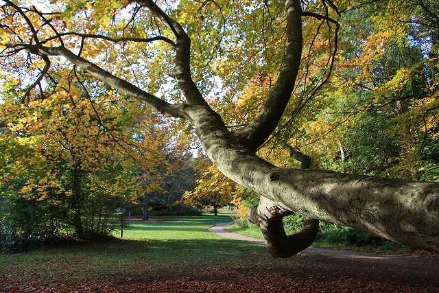 Brandon Country Park
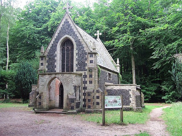 Edward Bliss's Mausoleum
The route joins the river near Brandon Stanch, now the limit of navigation on the Little Ouse, though lighters used to continue on to Thetford. This is the first of eight stanches, primitive precursors of locks, which used to help the lighters along the way.
Each stanch was a removable dam of timber beams. Lightermen going up river would tie up above the stanch, put the beams into position, and wait for the water to rise sufficiently for them to proceed. Idle moments were whiled away fighting rival crews for supremacy.
The route heads away from the river past the 17th century Brandon Hall, whose beautifully textured walls glisten with black flint between red brick headers. A former owner, John Julius Angerstein, made a fortune in the Australia goldfields. He spent most of it on paintings that now form the nucleus of the National Gallery collection.
Opposite the entrance to Brandon Hall, an avenue of pollarded limes leads the eye to the flint and clunch St Peters church. Most of the building was completed in the 14th and 15th centuries, a time of prosperity which is reflected in the restrainded ornamentation of the building.
The church is now in a fairly isolated position, but was once at the centre of the old town. The river was first bridged at the point where this walk leaves it, and this area, Town Street, was the focus of life in Brandon until the current bridge was built in the 16th century.
Scot’s pines were introduced to the Breckland in the 18th and 19th centuries, when they were planted to stabilise the light, sandy soils. In the early 1920’s, great tracts of near-derelict land to the south of the town, which had been bought cheaply at the depths of the agricultural depression, was planted by the Forestry Commission with Scots and Corsican pine.
The area around Brandon is now seen by some as little more than a timber factory though some see it as a wildlife resource. About 250 red deer roam the forest glades, with similar numbers of fallow deer and larger populations of roe deer and the Asian muntjac. Perhaps the last population of red squirrels left in East Anglia also live here. Coal tits and crossbills feast in the trees.
Brandon Country Park was established in 1973 around Brandon Park House, now a hotel. The park has been created on the remnant of the estate which was turned over to the County Council by the Forestry Commission who acquired it in 1927. The route leads through the Country Park to a road, which takes you back into the town through some modern London overspill housing, designed to reverse the post war trend towards the population of the Brecklands.
The Brandon Heritage Centre explains in detail the area’s economic and social history. In Market hill, now a paved precinct, a market has been held since 1319, and still brings the town to life on Thursdays and Saturdays. Nearby, behind the Flintknappers pub, was one of the places where flints were shaped by men carrying on Britain’s oldest industry, associated with this area since time immemorial.
Acknowledgments: Text derived from the Out and Out Series; Discovering the Countryside on Foot. Pictures courtesy of Wikipedia.


