Bury St Edmunds and Hardwick Heath
Through the 11th century streets of a fine cathedral town
Google Maps Open Source Maps| Statistics and Files | ||
|---|---|---|
| Start: Parkgate | Distance: 6.3 miles (10.1 km) | Climbing: 88 metres |
| Grid Ref: TL 84897 64327 | Time: 3 hours | Rating: Easy |
| GPX Route File | Google Earth File | Bury St Edmunds |
| Statistics | |
|---|---|
| Start: Parkgate | Distance: 6.3 miles (10.1 km) |
| Climbing: 88 metres | Grid Ref: TL 84897 64327 |
| Time: 3 hours | Rating: Easy |
| GPX Route File | Google Earth File |
Ordnance Survey Explorer Map (1:25,000)
The Walk: The ancient town of Bury St Edmunds, known ecclesiastically as St Edmundsbury and to the locals as plain Bury, was laid out around an abbey in a very early example of town planning. The abbey contained a shrine to Edmund the Martyr, a Saxon king sanctified soon after his death, and was one of England's most holy places of pilgrimage, long before Canterbury.
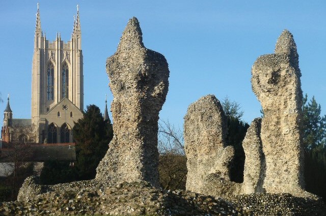 Bury St Edmunds Abbey and Cathedral
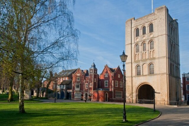 Bury St Edmunds Norman Bell Tower
Bury livestock market, near the start of the walk, is at its pungent best on Wednesdays, when crowds of farmers idle away the time between exchanging all things agricultural with endless discussions about hardship and the demise of farming in Suffolk.
Cornhill marks the western end of the medieval street plan and Moyses Hall guards its northern exit. The oldest of all East Anglia's secular buildings, it dates from the 11th century. Expensively dressed in limestone in an area of flint rubble building, its origins are uncertain, but it was probably the townhouse of the prosperous merchant. Since then, it has been used as a prison workhouse, a police station, railway offices and for the past century a museum. Heavily restored by Gilbert Scott in 1858, its interior remains as fascinating as the displays of artefacts that have shaped the area over the centuries.
The old town hall, across Cornhill, was improved by Robert Adam, who added four fine facades to the old market hall. Renovations have long been a feature of the town, and many seemingly 17th and 18th century buildings are actually much older. Of particular interest is Cupola House, which is now a bar/ restaurant. Built in 1693, it was recorded sympathetically five years later by the indefatigable traveller and diarist, Celia Fiennes: the house of Thomas Macro was "new made of building four rooms on the floore, pretty sizeable and high, with a lanthorn at least sixty steps up from the ground and gives a pleasing prospect of the whole town".
Just beyond is 'The Nutshell', a candidate for the title of Britain's smallest pub. If you can squeeze in there, you may enjoy a quiet glass of local Greene King 'Abbot Ale'. The Corn Exchange at the top of Abbeygate Street, comes to life for two weeks in the middle of May for the Bury Festival, which attracts performers of international repute, supported by famous orchestras.
Abbeygate Street leads down between Georgian shop fronts to Angel Hill. The Abbey Gate, built between 1430 and 1440, forms a beautifully carved framework to the former courtyard of the ruined Abbot's Palace, one of the greatest in Europe. Much of the palace fabric has been recycled into more recent local buildings, and in its place are the Abbey Gardens. In their north-eastern corner, 800 year old Abbots Bridge spans the River Lark.
Bury St Edmunds is a past winner of the 'Britain in Bloom' competition and the gardens contain great circles of formal flower beds. As well as more secluded areas, one of these is the site of the High Altar where, on 20th November 1215, the barons 'swore at St Edmunds Altar that they would obtain from King John the ratification of Magna Carta'.
Edmund, the pacifistic last king of the Angles, was killed in 870AD by the Danes, perhaps at Hoxne, close to what is now the Norfolk border. Edmunds remains were removed to Bury and the shrine was constructed to honour his memory. The English long held his death to be a martyrdom, and for many years he was the country's patron saint.
To help resolve discord between the English and Danish communities, King Canute gave a charter of liberties to the shrine, and in 1020 replaced secular priests with Benedictine monks. Canute added royal grants and one of his successors, Edward the Confessor, gave great possessions. Bury St Edmunds Abbey became one of the richest in England and a goal of pilgrimage to people throughout Europe.
After the Norman conquest, the Abbey was replanned on an even grander scale. It is the remains of these buildings that survive today. The church became one of Europe's largest, richest and most powerful.
Its influence did not always go unchallenged. In 1327, townspeople sacked the Abbey, protesting against monastic control. During the 'Peasant's Revolt' 50 years later, the prior was beheaded as he attempted to flee the building. In 1539, following the 'Dissolution of the Monasteries', the fabric was sold for 412 pounds, twelve shillings and four pennies. Much of its stonework was gradually recycled into the building of an expanded town.
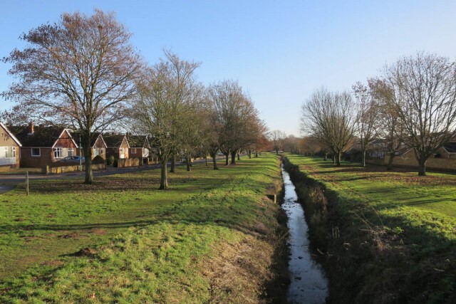 River Linnet in Holywell Meadows
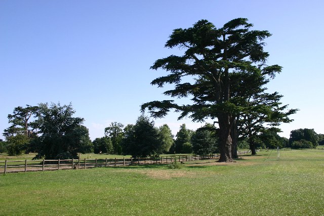 Hardwick Heath
At Angel Corner is an elegant Queen Anne house, belonging to the National Trust and containing a memorable collection of clocks. Among the timepieces, are paintings by Reynolds and Tissot.
Angel Hill itself was the site of Bury Fair, a great commercial and fashionable attraction throughout the Middle Ages and right up until the 19th century. The Athenaeun contains a ballroom built by Francis Sandys. He was the architect of nearby Ikworth House, three miles (4.8 kilometres) to the south-west. Charles Dickens read extracts from his works in the Athenaeun and lodged at the Angel, a great Georgian inn with a 13th century undercroft.
The large perpendicular Cathedral Church of St James and St Edmund was designated a cathedral in 1914. Its long, 16th century nave leads to pleasantly coloured modern additions. Next to it is the great Norman detached bell tower. recently restored and looking as if it has just been built.
The lime tree walk from the tower through the great medieval churchyard towards St Mary's Square, with the scent of hops in the air, is one of the delights of Bury St Edmunds. Hidden deep in the cow parsley in summer is the forgotten grave of a child 'struck dead by lightning while saying her prayers'.
St Marys Square was the pre Norman marketplace. With its lawns and raised flower beds, it retains the spacious feeling of an earlier age. It contains a plaque to Thomas Clarkson, William Wilberforce's aid in the campaign against slavery.
Nearby is the splendid Theatre Royal, owned by the National Trust. It was designed in the Regency by William Wilkins, architect of the National Gallery and Downing College, Cambridge.
Friars Lane leads out of town to Hardwick Heath, noted for its cedar trees and backdrop of fine oaks and beeches. From the far end of the heath, a path between unfenced fields leads to a trig point by a small thicket. Two miles (3.2 kilometres) from the centre of town, and only 276 feet (84 metres) above sea level, it is a place of seclusion shared only with skylarks rising in the steady breeze.
The return route through the town passes noble St Mary's Church, which has a marvellous late 15th century hammer-beam roof, heavy with angels, in its nave, and a wagon roof on the chancel, both among the finest examples of their kind. The church was rebuilt in 1424-33 to replace an Anglo-Saxon minster church displaced by the Norman abbey. In front of the altar is the tomb of John Reeve of Milford, last abbot of Bury. Mary Tudor is also buried here.
Another interesting religious building is the Unitarian Chapel in Churchgate Street. Built in 1711-12, its exuberant red brickwork and confidently curved windows house a period piece interior that is sternly overlooked by a double decker pulpit of noteworthy proportions. Churchgate Street marks the central axis of the 11th century grid of streets. Though blurred by time and scarred by fire, the street plan remains essentially intact, forming a framework to this most charming and historic county market town.
Acknowledgments: Text derived from the Out and Out Series; Discovering the Countryside on Foot. Pictures courtesy of Wikipedia.


