Castle Acre - Priory, Village and Castle
A ramble around an attractive village on a Roman road
Google Maps Open Source Maps| Statistics and Files | ||
|---|---|---|
| Start: Priory Car Park | Distance: 2.0 miles (3.3 km) | Climbing: 37 metres |
| Grid Ref: TF 81388 14915 | Time: 1 hour | Rating: Easy |
| GPX Route File | Google Earth File | About Castle Acre |
| Statistics | |
|---|---|
| Start: Priory Car Park | Distance: 2.0 miles (3.3 km) |
| Climbing: 37 metres | Grid Ref: TF 81388 14915 |
| Time: 1 hour | Rating: Easy |
| GPX Route File | Google Earth File |
Ordnance Survey Explorer Map (1:25,000)
The Walk: Castle Acre is a quiet, compact village packed with historical interest. Within its boundaries are a ruined castle and priory, and an ancient church and gateway. It sits astride of one of the oldest Roman roads in Britain, and is set in wonderfully lush, green countryside, watered by the sparkling River Nar.
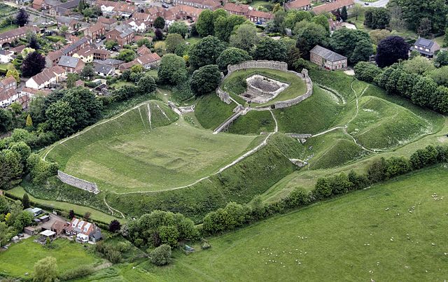 Overhead view of Castle Acre
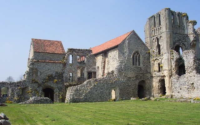 Castle Acre Priory
The tranquil Nar valley was recognised by medieval monks as an ideal setting for a self sufficient community. Castle Acre Priory, whose ruins are the starting point of this walk, was probably founded in 1090 by the son of William de Warenne, who came to England with William the Conqueror. Impressed by the serene life of the monks in the Benedictine abbey at Cluny in Burgundy, France, he introduced the Cluniac order to England.
Up to 30 monks lived here until the priory was dissolved by order of Henry VIII in 1537. The remains visible today include the impressive 12th century west front of the priory church, with its tiers of wall arcading and intricate moulding, and the splendid Prior's Lodging.
On the way into the village, the route passes Priory Lodge, which has some interesting chequered stone and flint work, and may once have been a chapel. A little further on is St James Church, a beautiful, mainly 15th century building, with some fine woodwork. The portraits of the Apostles on its rood screen are 15th century, as is the wineglass pulpit, typical of Norfolk churches. There is also a soaring, delicately carved font cover.
Stocks Green has many fine flint and brick buildings. Number 2, a brick cross set in its wall, was a hostel for pilgrims visiting the Priory. The Ostrich was once a coaching inn.
The carved wooden village sign is a typical East Anglian feature. Such signs often depict some historical figure or event linked with the village. Castle Acre's sign shows the prior church and a monk.
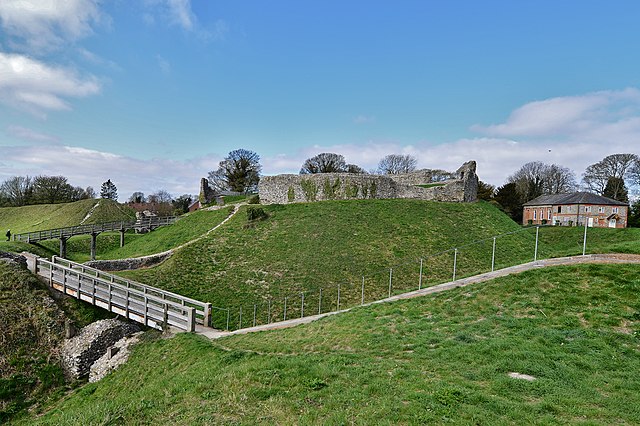 Castle Acre Castle
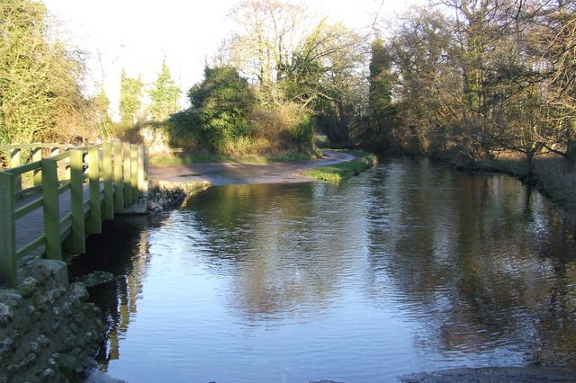 Ford on the River Nar at Castle Acre
You walk through the Bailey Gate, once part of the castle fortifications and the north gate of the medieval planned town of Acre. Its round, flint towers are intact. and portcullis grooves are still visible between the arches. Bailey Street beyond contains some interesting houses, including the Arch House (second left after the Bailey Gate), which seems to have been built in part with stones from the priory.
Just off Bailey Street is Pales Green, surrounded by earthworks called the Dyke Hills. This was the open area in the centre of the fortified bailey, or outer compound, and may also have been the market place. Tudor Lodgings, the large house at the lower end of Pales Green, was built in 1589 by Sir Thomas Gresham, a local merchant. It was originally two dwellings and has some fine flint work.
The castle was founded soon after the Norman Conquest. Originally a country house, it was converted to a castle keep in the 12th century. Several English kings are known to have stayed here. Although it became derelict in the late 14th century, the surviving earthworks and walls are still impressive.
There is evidence of Roman occupation at Castle Acre, which lies on the route of the Peddars Way, built nearly 2,000 years ago to provide access for Roman troops to the territory of the rebellious Iceni tribe. Intermittent uprisings in AD61 culminated in the crushing of a rebellion led by Queen Boadicea.
The road, which in places weaves about in a most un-Roman fashion, can still be traced today and walked for 45 miles (72 kilometres), from Knettishall to Holme-next-the-Sea. Our route follows the Peddars Way exactly from the Bailey Gate to a ford on the River Nar. This is an attractive spot to rest with an excellent view of the priory before returning to the start.
Acknowledgments: Text derived from the Out and Out Series; Discovering the Countryside on Foot. Pictures courtesy of Wikipedia.


