Blickling Park, Blickling Mill and Aylsham
From a 17th-century house and gardens to a historic market town
Google Maps Open Source Maps| Statistics and Files | ||
|---|---|---|
| Start: Blickling Mill | Distance: 9.1 miles (15.3 km) | Climbing: 138 metres |
| Grid Ref: TG 17569 28650 | Time: 4 hours | Rating: Moderate |
| GPX Route File | Google Earth File | About Blicking Hall |
| Statistics | |
|---|---|
| Start: Blickling Mill | Distance: 9.1 miles (15.3 km) |
| Climbing: 138 metres | Grid Ref: TG 17569 28650 |
| Time: 4 hours | Rating: Moderate |
| GPX Route File | Google Earth File |
Ordnance Survey Explorer Map (1:25,000)
The Walk:
Blicking Hall is a major National Trust property in fine countryside near Aylsham. This route explores the house and village of Blickling, and takes in some fine parkland walking. The National Trust inherited Blinkling Hall, together with its farms, cottages and 4,500 acres of land, on the death of the 11th Marquess of Lothian in 1940.
In the reign of Elizabeth I, Sir Henry Hobart, bought a moated manor here, and proceeded to replace it with the current house, which was largely completed before his death in 1625. The architect was Robert Lyminge, who a few years earlier designed Hatfield House. The two houses have many features in common, including the corner cupolas and the central clock tower.
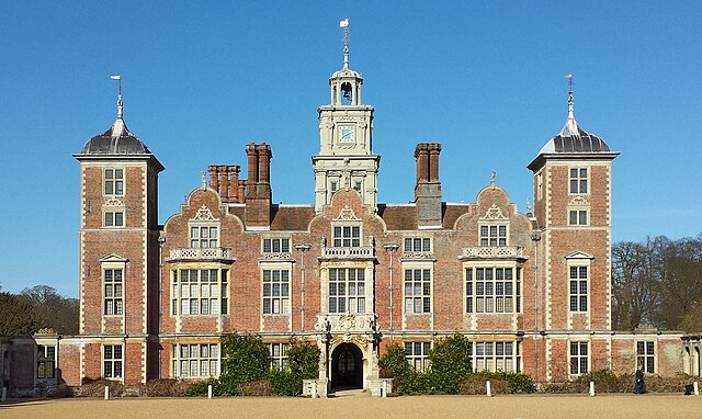 Blickling Hall
 Blickling Mill
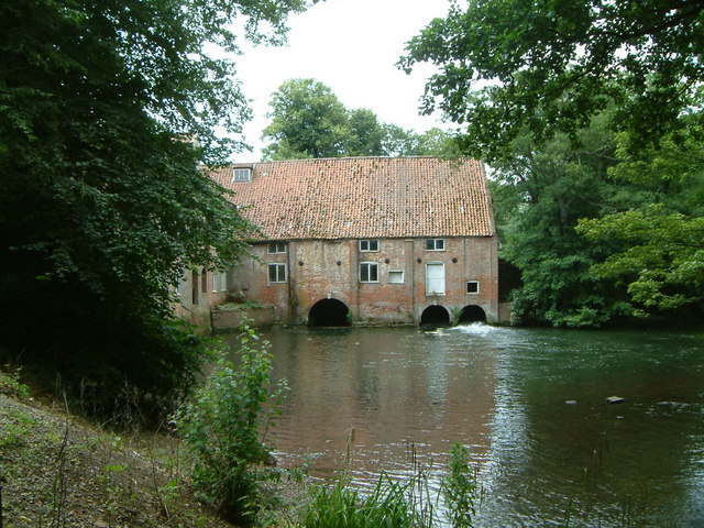
As you begin the walk, you get a good view, between massive yew hedges, of the south elevation flanked by its impressive Dutch gabled service wings.
The gardens are as fine as the house. They were substantially redesigned between the wars by Nora Lindsay. On the west side of the hall, in the former orchard, is a large garden centre where you can buy plants raised here. It is often open when the hall and gardens are closed.
The route leaves the grounds, and passes a fine barn behind the Buckinghamshaw Arms, before entering Blickling Park. The park was ploughed up in World War Two to grow food, but it is now fully restored.
There are several public paths crossing the park and the walk follows the most important one, The Weaver's Way. This is a 56 mile (90 kilometre) route which joins Cromer on the north Norfolk coast with Great Yarmouth on the east Coast. Long sections of it follows the course of the former King's Lynn to Great Yarmouth line of the Midland and Great Northern Joint Railway.
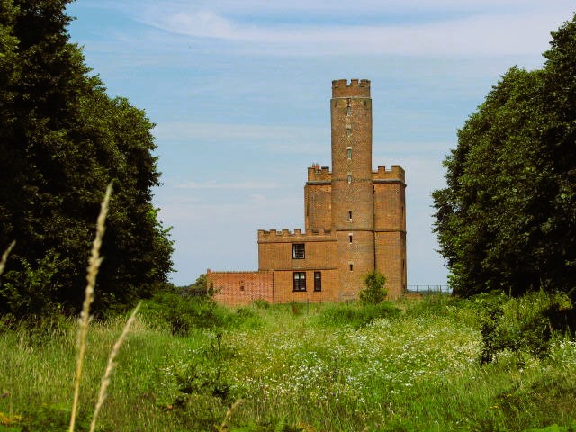 Blickling Tower
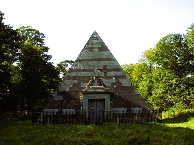 Blickling Mausoleum
Blickling Tower is visible away in the south-west corner of the park. A square brick construction with a cylindrical tower and crenellations, it was built about 1770 to give a grandstand view of a racecourse that has since vanished. It was converted to a house around 1860.
Between widely spaced yew hedges, on the near edge of some woods, you can see the dark grey bulk of a stone pyramid, 35 feet (10.5 metres) square, and about the same height. John Hobart, Earl of Buckinghamshire and his two wives are interred in this mausoleum, which was consecrated in 1797.
Beyond the trees, the walk leaves the park to visit disused Blickling Mill. It is sited on the River Bure, which rises on the Cromer-Holt Ridge, and meanders westwards to Great Yarmouth.
You take another route back through the park and beyond the hall to St Andrews Church. In it are many memorials to people who have lived at the hall. Among the brasses are some dedicated to members of the Boleyn family. Anne Boleyn's grandfather once owned the estate. There is also a fine effigy of the 8th Marquess of Lothian, carved in 1878.
Across from the church is an ice house, a domed brick structure with steps down to an underground cavern. Winter ice from nearby ponds was stored here, insulated by layers of straw to keep perishable goods fresh in the warmer months.
 Aylsham Mill
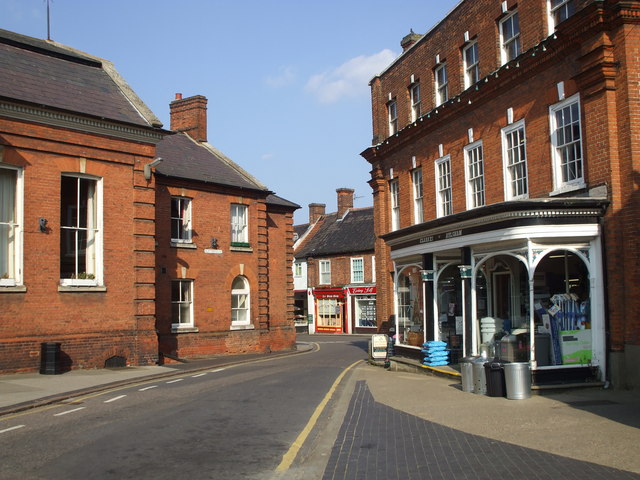 A corner off Aylsham town centre
A slight detour on the way into Aylsham takes you to a bridge over the River Bure, from which there is a view of the magnificent Aylsham Mill. The mill can be seen at closer quarters at the end of Mill Row. The Domesday Book records a mill here. The present building, 13 bays wide, was constructed in 1798. Beneath the pantilled roof are two white painted lucams, overhanging structures which housed lifting gear.
Aylsham is a small market town of Saxon origin. In the 14th century, the king gave the manor to John of Gaunt, who made it the administrative centre for Norfolk. Aylsham, like many market towns in East Anglia, prospered from the wool trade in the 16th century. Flemish weavers who settled here taught their skills to the locals, and the town produced its own type of cloth.
There are several things to see in the town square, including the Town Hall and the Black Boy, an old coaching inn with a black and white frieze under the roof line. On the corner of Barclays Bank is a plaque to Christopher Layer who died in the Jacobite cause.
The John Soame Memorial Pump stands on an island site at Carrs Corner in Penfold Street. It was erected in 1913 to commemorate the life of the Aylsham worthy. It must have been an exceptionally useful memorial, for it was not until 1938 that Aylsham had a piped public water supply. The memorial was provided with an endowment to pay for it to be regularly rethatched with Norfolk reed.
Just north of Market Place is the parish church, Saint Michael's, which dates mainly from the 14th and 15th centuries, and contains some good brasses. In the churchyard, near the east end, is the grave of the landscape architect Humphrey Repton, who it is believed, had a hand in laying out the park at Blickling. Repton wrote his own epitaph, which you will see on his grave.
The return to Blickling is along roads and field paths, ending with a bridleway which runs alongside the road back to the hall.
Acknowledgments: Text derived from the Out and Out Series; Discovering the Countryside on Foot. Pictures courtesy of Wikipedia.


