Walton-on-the-Naze and Frinton-on-Sea
Two popular resorts and a lonely headland where wildlife thrives
Google Maps Open Source Maps| Statistics and Files | ||
|---|---|---|
| Start: Railway Station | Distance: 8.3 miles (13.4 km) | Climbing: 56 metres |
| Grid Ref: TM 25179 21456 | Time: 4 hours | Rating: Easy |
| GPX Route File | Google Earth File | Walton-on-the-Naze |
| Statistics | |
|---|---|
| Start: Railway Station | Distance: 8.3 miles (13.4 km) |
| Climbing: 56 metres | Grid Ref: TM 25179 21456 |
| Time: 4 hours | Rating: Easy |
| GPX Route File | Google Earth File |
Ordnance Survey Explorer Map (1:25,000)
The Walk:
The seaside towns of Walton-on-the-Naze and Frinton-on-Sea sit side by side at the easternmost tip of Essex. Both have longer histories than their buildings suggest; Frinton appears as Frietuna, in the Domesday Book, and prehistoric pots and weapons are regularly uncovered by the tide on the Naze.
The branch line to Walton-on-the-Naze Station, where the walk begins, was completed in 1867 to serve what by then had become a busy coastal resort. The route leads down some steps to the beach, which is covered at high tide. In summer, this area is packed with holiday makers, having a good old day out at the seaside, complete with rock, candy floss and amusements on the pier.
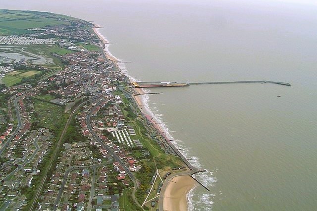 Walton-on-the-Naze
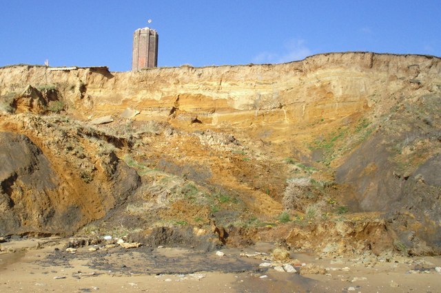 The Naze Cliffs and Naze Tower
This is Walton-on-the-Naze's second pier, the first built in 1830 for £1,000, was 300 feet (91 metres) long and was used by London to Ipswich Steam Packet Boats. In 1880 it was washed away in a storm. The current pier was built in the 1870's. It was extended in 1898 to 2,610 feet (796 metres), the second longest in the country, and was provided with three steamer berths.
Beyond the pier, the route climbs gently alongside the shore, to give a good views out to sea. Ahead of you is the Naze and a tall, octagonal brick construction. This is the Naze Tower, built in 1720 on the highest point of the headland by Trinity House as a landmark for shipping.
In the 19th century, the Naze Tower was used by the Coastguard and the Navy as a semaphore signalling station to ships on manoeuvres. During World War Two, the RAF fitted a radar scanner on top of it.
From the Naze Tower, you follow the edge of a crumbling cliff. On the beach below are two concrete pill boxes. These World War Two defences were built well back on the cliffs, and today they provide alarming evidence of the rate of erosion on The Naze, whose name is a variant of 'ness'.
As the cliffs peel away, an abundance of fossils is revealed. In an area of cliff near the tower known as Red Crag, 148 different species of fossilised molluscs have been found. The most common is a whelk, identical to the modern form, except that the shell is coiled the opposite way. Prospecting palaeontologists are a common sight on the beach.
As you walk the springy turf of the cliff top, you skirt a thicket of elder trees and vivid yellow gorse. A variety of butterflies, including red admirals, Essex skippers, common blues, painted ladies, meadow browns and peacocks, floats by on the sea breezes. Ahead, on a clear day, there are views up the coast as far as Harwich and Felixstowe.
The route slopes gently down to a beach that merits close inspection. Neolithic tools and pots are washed up here, with the regularity that points to a factory-like scale of production. A 4,000 year old body was found in a pit nearby, with its stomach contents so well preserved that orache seeds, blackberries and rosehips could be distinguished. The Beaker folks settlement has, however, long since been given up to the waves.
You follow a sea-wall past a fenced off section of the John Weston Nature Reserve, named after a leading Essex naturalist. It covers nine acres and is run by the Essex Wildlife Trust.
The marshes and beaches to the right are also fenced off during the breeding season of the ringed plover, oystercatcher and the little tern. The terns, which winter in Africa, have been in decline on Britain's coasts due to the intrusion of holidaymakers and English Nature is currently making every effort to rectify this.
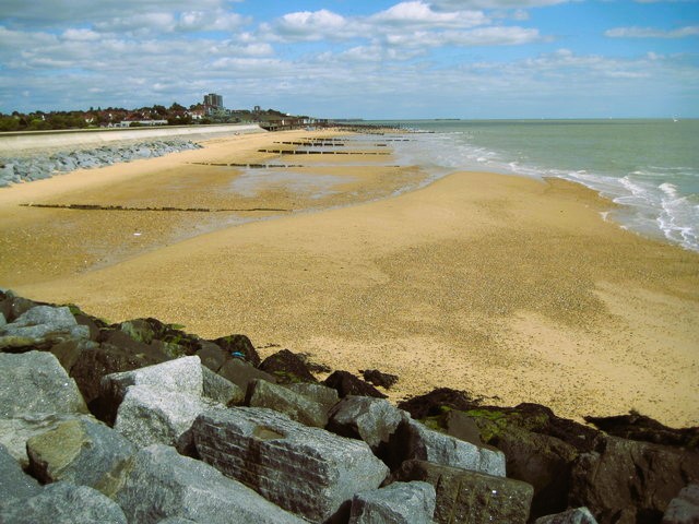 Frinton-on-Sea Beach
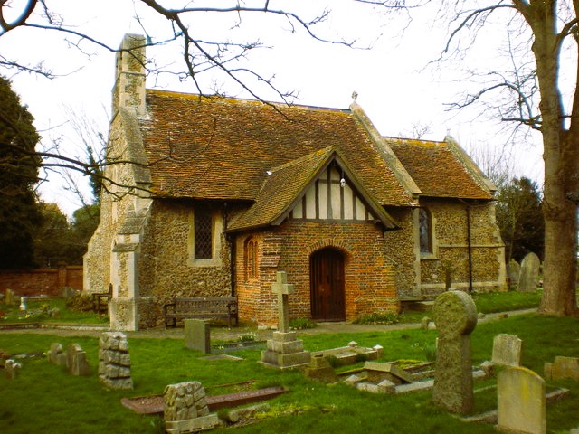 St Mary's Church, Frinton-on-Sea
The sea wall bends round the headland back towards Walton-on-the-Naze. On your right is a marshy estuary of Walton Channel, with boats bobbing at their moorings, while on your left is a pleasant bucolic landscape.
Ahead in the distance, the flat round bulk of a Martello Tower is just discernible. These towers, built against the threat of a Napoleonic invasion, were assigned letters. The original two at Walton were 'J' and 'K'. Each contained a twenty-four pounder cannon and a howitzer, aligned in overlapping arcs of fire. Tower 'J' was sold in 1836 for its bricks, which were used to construct cottages in the town. For many years, 'K'was used by the Coast Guard.
The path reaches Foundry Dock. In the 19th century, the foundry employed 300 men, and barges transported pumping machinery, steam engines and turbines, as well as machinery for rubber plantations. The foundry closed in 1921.
As you head away from the water along a path alongside a hedgerow, you pass a pond that is used for releasing rescued wildfowl back into the wild. After a short stretch of road, you turn down an alleyway to return to the sea front by the Old Lifeboat House, which is open in season with an exhibition of lifeboats and coastguards.
Beyond Walton Station is Frinton-on-Sea, an altogether more genteel, sophisticated resort, with huge Victorian and Edwardian villas. The sea wall and promenade were created in 1903, with 32 breakwaters to trap the beach and the sun, and to temper the ozone-rich breeze.
A stroll along the Greensward leads to old St Mary's Church. Church records go back to 1129, and parts of the nave are Norman in origin. After storms severely reduced the useful part of the church in 1703, it claimed for a while to be the smallest church in the world; it is still is the smallest in Essex. From here, you amble up Main Street to Frinton-on-Sea railway station and catch a train back to the start at Walton-on-the-Naze railway station.
Acknowledgments: Text derived from the Out and Out Series; Discovering the Countryside on Foot. Pictures courtesy of Wikipedia.


