Orford and Orford Ness
A walk around the medieval port of Orford and its rich marshlands
Google Maps Open Source Maps| Statistics and Files | ||
|---|---|---|
| Start: Orford Quay | Distance: 4.8 miles (7.7 km) | Climbing: 26 metres |
| Grid Ref: TM 42518 49516 | Time: 2 hours | Rating: Easy |
| GPX Route File | Google Earth File | About Orford |
| Statistics | |
|---|---|
| Start: Orford Quay | Distance: 4.8 miles (7.7 km) |
| Climbing: 26 metres | Grid Ref: TM 42518 49516 |
| Time: 2 hours | Rating: Easy |
| GPX Route File | Google Earth File |
Ordnance Survey Explorer Map (1:25,000)
The Walk:
Orford, dominated by the towers of its castle and church, is situated on a wild desolate stretch of the Suffolk coast. Over the centuries, its fortunes have been inexorably entwined with the Ness, one of Britains largest shingle spits. For at least 1,000 years, Orford Ness has crept southwards from Aldeburgh, effectively damming the River Alde's outfall and so forcing the river to flow down the coast and round the end of the spit; where the frustrated Alde reaches Orford, it changes its name to the River Ore.
The average growth rate of the Ness is some 50 feet (15 metres) per year, though progress varies from decade to decade. Advance was sabotaged in 1898 when the violent storm shortened it by one mile (1.6 kilometres). Currently, it is some 10 miles (16 kilometres) long, and at its widest point measures one mile (1.6 kilometres) across.
In the 1085 Domesday Survey, Orford was not even mentioned, but within fifty years the farming and fishing village had become sufficiently important to have a market. Around this time, the end of the spit lay directly offshore, transforming Orford waterfront into a safe, sheltered Haven. As a result, in 1165 when Henry II decided to build a stronghold in East Anglia, he chose Orford. His castle took eight years to complete and cost £1,413 9 shillings and two pennies - in those days a great sum. It served as a fortress for 200 years, then passed into private hands.
From the 12th century onwards, Orford flourished as a busy market town and prosperous port, its wealth based on fish - herring, sprats and oysters - and on the wool trade. In medieval times, wool was Suffolk's main export and the grazing lands around Orford supported huge flocks of sheep.
But in the mid 1500's the Ness, which had contributed greatly to Orford's rise now brought about its fall. From about 1530, the spit had rapidly thrust further south, restricting the harbour entrance. Orford's fortunes declined. Today, Orford survives as an attractive village full of character; during the summer months it is very popular.
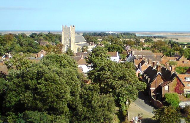 Orford village and St Bartholomew Church
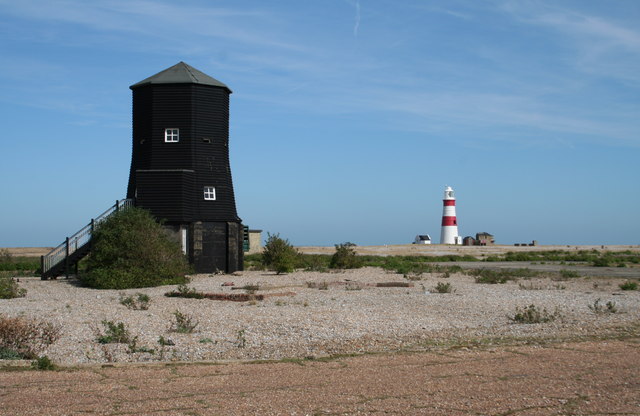
The walk starts at the quay, which, long since filled in and paved over, bears no resemblance to the bustling harbour of former centuries. The hump at the end of the road is an anti flood measure designed to prevent water flowing up Quay Street. As a general protection against flooding and to reclaim low-lying land, the sea wall was built in stages, from the 12th century onwards. Even so, on several occasions, storm waters have breached the wall and swept over the marshes, turning the village's high ground centre into an island.
The quay area is associated with Orford's most celebrated legend: the Merman (Orford Ghost). In the late 1100's local fishermen caught a wild man in their net. He was completely naked but covered with hair; although imprisoned in the castle and horribly tortured he refused to talk - probably because he could not. However, he did eat everything he was given, both raw and cooked, and always slept between sunset and sunrise. Eventually he was taken back to the harbour and, heavily guarded by the fishermen and their nets, allowed to re-enter the water. Diving down deep under the nets he managed to escape but, surprisingly returned to custody of his own free will. At a later date, however, he gave his captors the slip, fled to the sea and was never seen again.
Across the River Ore, on the Ness, are some deserted Ministry of Defence buildings. During World War I, an airfield was built on the site and aircraft stationed there, while during World War II the spit was used for ballistic experiments. In the 1930's Robert Watson-Watt carried out his early research into radar on Orford Ness. The various MOD stations on the Ness have now closed.
From the key the path leads through to the seawall and almost immediately passes the reins of old oyster beds. Since earliest times, oysters have been a speciality of the rivers awe and old. Excavations at a nearby Roman villa have revealed a large number of oyster shells. Oyster fisheries grew in importance over the centuries and by the 1600s were subjected to strict controls under the supervision of a special water bareliff. One of his duties was to measure the oyster so that no undersized ones should be gathered Today, oysters are grown around the corner in Butley Creek rather than of offered itself and sold in the Butley Oysterage Shop and restaurant on Market Hill. The Oysterage also specialises in smoked fish.
The seawall path follows the Ore round to Chantry Point. Here the river divides into the Gull - a medieval word meaning channel - and the Narrows, with Havergate Island lying between them. The island, 2 miles (3.2 kilometres) long, and covering about 267 acres, probably dates from the mid 1500's, the same era as the shingles spits southward thrust. Traditionally used for grazing sheep and cattle (and for smuggling), the island was bought by the RSPB in 1948 as a nature reserve and has since become one of Britain's most important breeding sites for the avocet (the RSPB's logo bird).
Although these elegant black and white waders were once spread regularly along the east coast, they became extinct in the mid 1800's, largely because their eggs were stolen, both for collections and cooking. The birds were also killed for their feathers, which were used as fishing flies. The island's colony now has a stable population, some of which stay all year round; and indeed, due to the success, they are colonising other parts of the country. Other birds found on Havergate Island include terns, redshanks, oystercatchers and ring plovers, as well as numerous wintering waders and ducks. The island is also noted for its salt marsh flora, butterflies and hares.
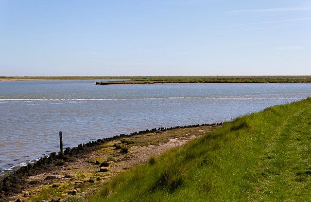 View to Havergate Island from Chantry Point
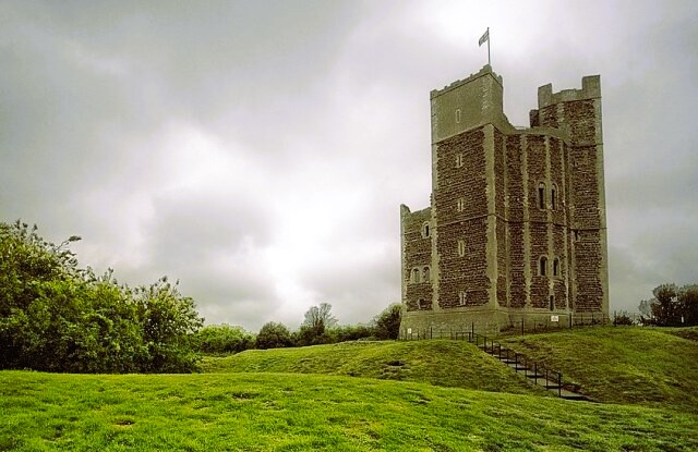 Orford Castle
Some distance beyond at Chantry Point, the walk heads inland and eventually climbs gently up to Gedgrave Broom. Though part of Tunstall Forest, an extensive Forestry Commission plantation - Gedgrave Broom is distinct in that it has always been wooded; however, it now contains stands of Corsican and Scots pine alongside the traditional broadleaves like oak, ash, lime and cherry. Wildlife includes three species of deer - roe, fallow and red. Birds such as nightjars, hobbies, woodlarks, skylarks, barn and tawny owls; and butterflies like the meadow brown, tortoiseshell and comma.
The route now heads in to Orford village with Orford Castle being the first place of interest. A castle with a tall and slender imposing keep, it was built between 1165 and 1173 by Henry II of England to consolidate royal power in the region. Next port of call is Orford Church. Dedicated to St Bartholomew, the ruined arches and pillars at the eastern end belonged to an original Norman church built in the 1160's - at the same time as the castle. In the 14th century, at the height of Orford's prosperity, the church was rebuilt in magnificent style with a tall, broad nave and sturdy tower. Most of the present building dates from this era.
The last stage of the walk heads south-east across reclaimed marshes to the sea wall. Straight ahead, the red and white tower of Orfordness lighthouse warns against the treacherous shifting shallows of the Suffolk coast. In medieval times, mariners had little to guide them except prominent landmarks such as windmills and church towers, and by night lighted beacons. At Orford there were at least two beacons, one on top of the castle and another on a nearby green. From the late 1500's there was such a restless surge of sand and shingle building up offshore that the waters became even more hazardous and the number of shipwrecks increased tragically. One stormy night in 1627, over thirty vessels foundered.
As a consequence, in 1634 two timber lighthouses were built on the Ness. The High Light pinpointed the Ness and also lined up with the Low Light to indicate a safe passage northwards off Aldeburgh. Over the next 250 years, the Low Light was replaced eight times, in most cases because its shingle site had been scoured away by the sea. It was eventually discontinued, and the High Light then became todays lighthouse. Dating from 1792, Orfordness lighthouse is one of the oldest on the east coast. It stands 99 feet (30 metres) high And its white light, flashing at 5 second intervals, can be seen for 15 miles (24 kilometres) around. Away to the left, further north along the Ness, are the tall masts of BBC World Service.
Acknowledgments: Text derived from the Out and Out Series; Discovering the Countryside on Foot. Pictures courtesy of Wikipedia.


