Hessle, Humber Bridge, Far Ings Nature Reserve and Barton Waterside
From a country park to a nature reserve across the Humber Bridge
Google Maps Open Source Maps| Statistics and Files | ||
|---|---|---|
| Start: Humber Bridge Country Park | Distance: 7.9 miles (12.7 km) | Climbing: 60 metres |
| Grid Ref: TA 01871 26087 | Time: 4 hours | Rating: Easy |
| GPX Route File | Google Earth File | About the Humber Bridge |
| Statistics | |
|---|---|
| Start: Humber Bridge Country Park | Distance: 7.9 miles (12.7 km) |
| Climbing: 60 metres | Grid Ref: TA 01871 26087 |
| Time: 4 hours | Rating: Easy |
| GPX Route File | Google Earth File |
Ordnance Survey Explorer Map (1:25,000)
The Walk:
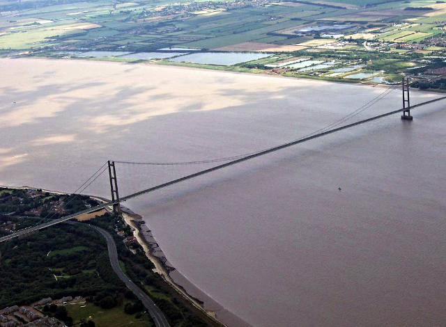
The Humber estuary is one of the most impressive estuaries in Britain, draining a fifth of all the rivers in England. The waters from the Derwent and Ouse from North Yorkshire, the Aire and Calder from the Pennines, and the great Trent meandering slowly north from the Midlands combine to create an estuary that is over five miles (8 km) wide at its mouth. Since medieval times the Humber has been an important commercial waterway and today, barges and ships still carry cargoes of biofuel and other commodities to inland ports.
Crossing this great estuary is the Humber Bridge, at its opening in 1981 the longest single-span bridge in the world; a record it held until 1998. To appreciate its full grandeur it has to be crossed on foot which is exactly what this walk does.
 Humber Bridge
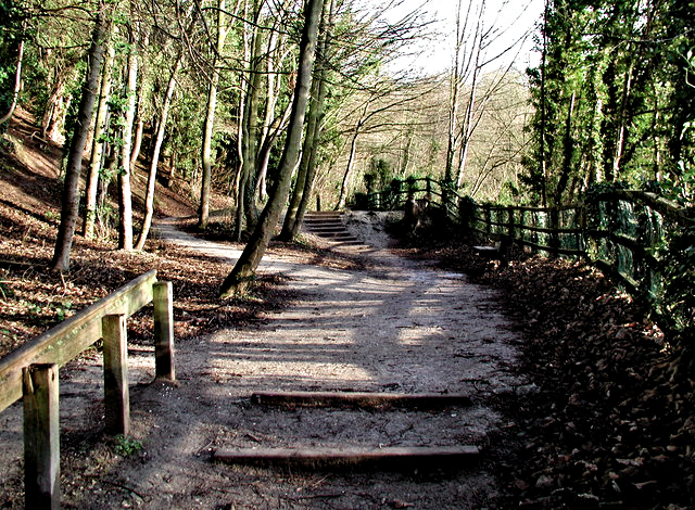 Steps in Humber Bridge Country Park
The walk begins from Humber Bridge Country Park, which is small and intimate. Its high sided wooded chalk cliffs are rich in wildlife and it is famous for its buddleia which attracts a huge variety of butterflies. On the foreshore is a five sided windmill that once drove rollers which crushed the chalk that was quarried here.
The Humber Bridge, which was opened by Queen Elizabeth II in 1981, took over eight years to build. It consists of thousands of tons of concrete and steel, and stands 100 feet (30 metres) above the Humber estuary. The bridge towers are 510 feet (153 metres) high, and the main span of the bridge is 4,700 feet (1,410 metres) long; by comparison the Golden Gate Bridge of San Francisco is a mere 4,250 feet (1,280 metres) long. From the eastern side you can see the City of Kingston Upon Hull, the North Sea ferries in the George V Dock and the cities oil refineries. Upstream the river curves towards Brough and Goole.
 Far Ings National Nature Reserve
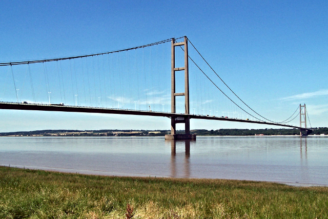 View of Humber Bridge from Barton Waterside
Stretching five miles along the southern foreshore of the estuary lie Barton Clay Pits and Far Ings National Nature Reserve. Since ending their industrial life the pits have been transformed into the largest area of freshwater marsh in the region. The flooded pits provide a mixture of dense reed beds and open waters bordered by scrub woodland, forming a superb wildlife sanctuary. There are over seventy species of breeding birds here, including tufted duck, pochard and cormorant. Fringing the clay pits is reed mace, water plantain, watercress and wild celery.
This walk provides the perfect opportunity to enjoy the wildlife show in the reserve as well as admiring the great expanse of estuary while ambling over the Humber Bridge. One word of caution, choose a day when it is not too windy, for any winds are stronger without any breaks to hold them back. and if too windy, the bridge will be closed for safety reasons anyway.
Acknowledgments: Text derived from the Out and Out Series; Discovering the Countryside on Foot. Pictures courtesy of Wikipedia.


