Kilnsea and Spurn Head
There and back on the full length of a narrow spit of land on the edge of Yorkshire
Google Maps Open Source Maps| Statistics and Files | ||
|---|---|---|
| Start: Kilnsea | Distance: 9.0 miles (14.5 km) | Climbing: 40 metres |
| Grid Ref: TA 41011 15789 | Time: 4 hours | Rating: Moderate |
| GPX Route File | Google Earth File | About Spurn |
| Statistics | |
|---|---|
| Start: Kilnsea | Distance: 9.0 miles (14.5 km) |
| Climbing: 40 metres | Grid Ref: TA 41011 15789 |
| Time: 4 hours | Rating: Moderate |
| GPX Route File | Google Earth File |
Ordnance Survey Explorer Map (1:25,000)
The Walk:
Spurn Head lies at the end of a spit of land which reaches our almost four miles into the Humber Estuary. About every 250 years, it is cut, washed away and reformed by the tides. The land further north along the coast becomes eroded away and the debris is washed down the coast to come to rest here.
This area is a National Nature Reserve operated by the Yorkshire Wildlife Trust. It is a popular landing place for migrating birds each spring and autumn and over 32 species of bird have been identified in the reserve. With global warming it is not unusual for new species to arrive in a new season. Among the interesting plants are the small, white flowered Spring Beauty and Pyramidal Orchid. Close to the Information Centre is a Heliogoland bird trap used for catching and ringing birds to discover their migration routes. Dunlin have been recovered in France, Sweden and Germany, a meadow pipit in Morocco, blackbirds in Norway and Denmark, plus a starling in Finland.
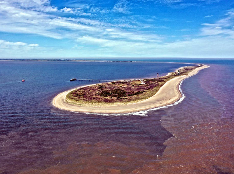 Spurn Head
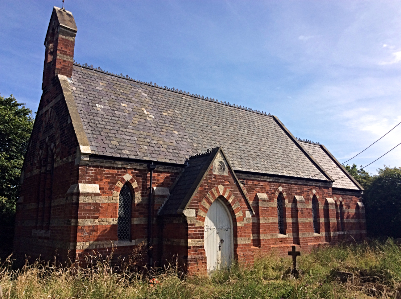 St Helen's Church, Kilnsea
The start of the walk is the car park in the hamlet of Kilnsea. After parking walk along the road, passing the Spurn Discovery Centre and continuing to the west shoreline of Spurn Head, where there is another car park. Here turn left along the shore following a rough track south. This leads onto the spit.
Because of its remote situation, the Humber lifeboat is the only one in Britain with a full time crew. The old lighthouse was built in 1852 and was used at one time as a magazine for storing explosives.
The first lifeboat was stationed on Spurn Head in 1810 and, over the years, many daring rescues have taken place. The lifeboat house was built in 1923 to accommodate a new Watson-type lifeboat. Coxswain Robert Cross, who operated the lifeboat at this time, was awarded the George Medal, two RNLI gold medals, three silver medals and two bronze medals for gallantry at sea during his 31 years service.
During summer, part of Spurn Head is fenced off to protect the nesting grounds of the Little Tern. This ground nesting bird produces nests of two to three eggs which are well camouflaged, making it easy for unwary walkers to tread on and destroy them. Behind the beach is an area overrun by sea buckthorn, which offers a haven for migrating birds.
Just offshore lie the Binks, Inner Binks and Middle Binks sandbanks. On a stormy night in 1915 the rowing lifeboat went to the assistance of SS Florence, which had run aground on Middle Binks. The lifeboat went aground too, some distance from the ship, so Coxswain Cross walked over the sandbanks taking a line to the ship. In the darkness he was engulfed by waves, but at the second attempt succeeded in getting a line to the ship and rescuing eight seamen. For his courage and bravery he received one of his three RNLI silver medals.
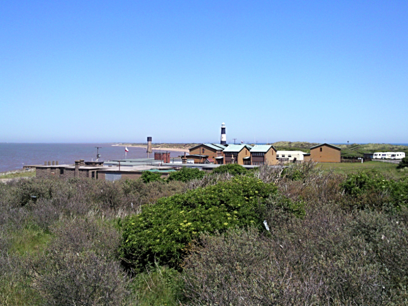 The settlement on Spurn Head
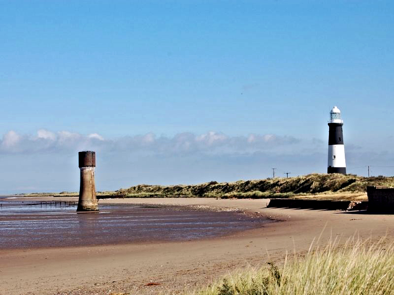 Former and present lighthouses on Spurn Head
A light was first erected on Spurn Head to guide shipping in 1428. it was looked after by a hermit who took tolls from passing ships. In 1676, another light was built on Spurn Head which by then was extended southwards. Trinity House replaced he lighthouse with newer versions in 1771, 1816 and 1831.
Close to the lighthouse stood the engine sheds of the Spurn Head Railway. The line ran between the hamlet of Kilnsea and Spurn Head and was built during World
War One. As well as regular engines, the line was used by a veteran racing car, converted by an army engineer to fit on the track. There was also a bogie with a sail that operated on the line when there was a favourable breeze.
Note: the walk can be shortened to a short 1.4 (2.2 km) stroll by setting off from the Spurn Head car park and doing the round circuit at the tip of Spurn Head. (Download the route here)
Acknowledgments: Text derived from the Out and Out Series; Discovering the Countryside on Foot. Pictures courtesy of Wikipedia.


