Hornby, Wray, River Wenning and River Lune
A walk with two castles and a quiet village where industry once thrived
Google Maps Open Source Maps| Statistics and Files | ||
|---|---|---|
| Start: Hornby | Distance: 6.1 miles (9.7 km) | Climbing: 103 metres |
| Grid Ref: SD 58544 68333 | Time: 3 hours | Rating: Easy |
| GPX Route File | Google Earth File | About Hornby |
| Statistics | |
|---|---|
| Start: Hornby | Distance: 6.1 miles (9.7 km) |
| Climbing: 103 metres | Grid Ref: SD 58544 68333 |
| Time: 3 hours | Rating: Easy |
| GPX Route File | Google Earth File |
Ordnance Survey Explorer Map (1:25,000)
The Walk: There are many glimpses of the past on this walk around the villages of Hornby and Wray, in Lancashire's Lune valley. The starting point is the bridge over the River Wenning, built in 1769, which carries the main road through Hornby. Historians think that Hornby was once the site of a villa belonging to a wealthy Roman. The evidence is the discovery of Roman coins and a brick pavement, and its proximity to Lancaster and the Roman camp at Barrow in Furness.
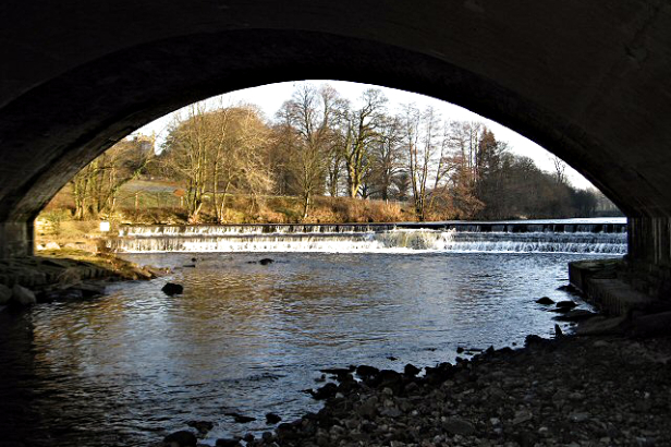 River Wenning at Hornby Bridge
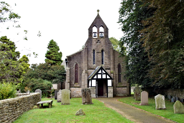 Holy Trinity Church, Wray
During the Norman Conquest, Hornby was in the hands of Alric, a Saxon chieftain. Later, it passed by marriage to Roger de Montbegon, who came over from France with William's conquering army. The foundations of Hornby Castle were probably laid by Montbegon, on the site of the Roman villa. After Montbegon, the castle was owned by the DeBurgh's, followed by the de Neville's, then the Harringtons.
Later, Hornby Castle was inherited by the Stanley family. Sir Edward Stanley fought at the Battle of Flodden (1513), supported by local yeomen. Sir Edward restored the 13th century keep, which is the oldest surviving part of the castle. He also built the octagonal tower (1514) at the Parish Church of St Margaret, as a thanksgiving for victory.
During the English Civil War, the castle was owned by the Parker's, and was a Royalist stronghold. After it was captured, Cromwell ordered it to be destroyed. Fortunately, this was never done, and a succession of later owners have each extended and improved the castle. The present castle is mostly 19th century.
The atmospheric setting of the castle, with its keep, turrets, battlements and mullioned windows, set high on a mound above the River Wenning, was appreciated by artists and poets. Three of Turner's best known drawings are of Hornby Castle, or the view from it. Thomas Grey wrote about the valley of the Lune and of the lands that were once part of Hornby Castle estates.
Hornby's situation between two fordable rivers, the Wenning and the Lune, means that a road has always passed through the village. The railway arrived later. At the end of the main street, you pass an unusual stone built into a wall above the fountain, depicting a cat holding a rat in its mouth. The monogram 'PD' on the stone stands for Pudsey Dawson, one of the originators of the railway line that ran from Wennington to Morecambe. The Cat and Rat Keystone was resited here when one of the stone railway bridges was replaced with a wider iron bridge.
On the next part of the walk, a bridge crosses the old railway, then lanes and tracks lead to the village of Wray, situated where the River Roeburn meets the River Hindburn. Wray is a village settled by Norsemen, 'wray' meaning 'an out of the way corner'. The main street has cobbled pavements, with 17th century farms, barns and cottages lining the road. Many of the cottages, set about with pretty gardens and window boxes, have datestones on their lintels.
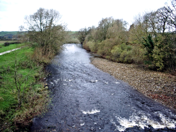 River Wenning
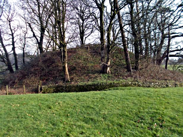 Site of Castle Stede
In Wray, farming and industry developed side by side. In years past, this quiet place was a hive of industry. There was a mill along the banks of the Roeburn, employing 100 people to spin the raw silk that came from China; it was then turned into silk hats. In the village, there were woodturners, nail makers, bobbin makers, wheelwrights and clog blockmakers.
The hedgerows of blackthorn, hawthorn and cherry, which line the lane on the way back towards Hornby, are interlaced with dog rose, downy rose and guelder rose, intertwined with honeysuckle and bindweed. The banks and verges support wood violets, primroses, dogs mercury, cuckoo pint, celandine and stitchwort, as well as stands of garlic mustard and cow parsley. Meadow cranesbill and greater bellflower may also be spotted. The hedgerows are popular in winter with fieldfares, redwings and other thrushes.
On the verge is a well preserved stone cross, a waymark on the old packhorse route, which went south on the fells above Wray. The packhorses carried salt and other vital goods. In the field behind the cross, the depression marks the old route. Nearing Hornby, at Butt Yeats, you pass the massive base of another stone cross.
The next part of the walk is along the banks of the Wenning and the Lune. There are several kinds of willow to be found on the river banks, and these were used in the past by basket makers of Arkholme, to the north of Hornby. At the river's edge, there are areas of sand and shingle, where dippers and wagtails are often seen and waders such as oystercatchers and common sandpipers search for food. The sandy banks provide nesting sites for sand martins. in winter, greylag geese fly over in formation to their feeding grounds.
Where the rivers meet, a priory existed 800 years ago. There is no trace of it now, but in the parish church of St Margaret in Hornby, below the octagonal tower, there are fragments of two crosses from the priory. One of these was chiselled over 1,000 years ago and depicts the Bible story of the Loaves and Fishes. This cross is unique in England. There are also tomb lids from the priory, with carvings of swords and chalices. A look at the churchyard also reveals the base of an Anglo-Saxon cross.
You leave the riverbank at Loyn Bridge, which carries the road across the Lune to Gressingham. It is a medieval stone bridge, bearing many mason's marks. The masons were required to put their own individual mark on their stones, so their workmanship could be checked by the master mason. Each gang or 'lodge' had its own mark to prevent the entry of unskilled workers.
Above Loyn Bridge is a fine example of a Norman motte and bailey. Called Castle
Stede, the site covers about three acres and both sections have moats. The pudding shaped motte is overgrown with trees (see picture) and there are raised earthen defences around the level bailey. From here, the lane soon brings you back past St Margaret's Church into Hornby.
Acknowledgments: Text derived from the Out and Out Series; Discovering the Countryside on Foot. Pictures courtesy of Wikipedia.


