Bishop Auckland, Binchester, Vinovia Roman Fort and Escomb
From a 12th century palace to a Roman Fort and out of the way Saxon church
Google Maps Open Source Maps| Statistics and Files | ||
|---|---|---|
| Start: Market Place | Distance: 10.6 miles (17.0 km) | Climbing: 294 metres |
| Grid Ref: NZ 20874 29988 | Time: 4-5 hours | Rating: Moderate |
| GPX Route File | Google Earth File | About Bishop Auckland |
| Statistics | |
|---|---|
| Start: Market Place | Distance: 10.6 miles (17.0 km) |
| Climbing: 294 metres | Grid Ref: NZ 20874 29988 |
| Time: 4-5 hours | Rating: Moderate |
| GPX Route File | Google Earth File |
Ordnance Survey Explorer Map (1:25,000)
The Walk: In the heart of County Durham, just south of where the old Roman road, Dere Street crosses the River Wear, is Bishop Auckland, the gateway to Weardale. In the Middle Ages, the area was an immense hunting ground. An elaborate palace was built here for the Prince Bishops of Durham, who ruled an area stretching from the River Tees almost to the River Forth. Often more powerful than the monarch, they raised their own armies to quell the Scots, held their own courts, and even minted their own coinage. This walk around the heartland of their domain begins in the marketplace, which has a distinctive continental air. The large town hall of 1860 is in Franco Flemish style, while the neighbouring buildings have prominent Germanic facades and elegant Grecian columns.
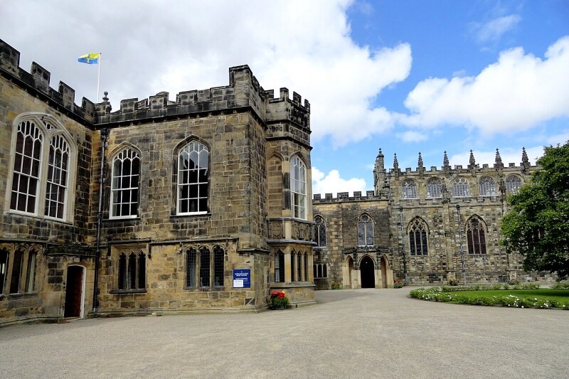 Auckland Castle
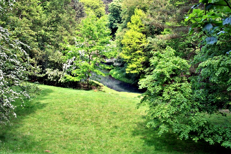 River Gaunless in Bishop Auckland Park
Victorian St Anne's Church, built in the early English style, is the fourth place of worship on the site. The first was well established by the end of the 14th century, when it was used to hold services for the overflow from the bishop's own chapel.
The route into town follows Newgate Street, which was built over Dere Street, and retains its straight Roman course beyond the bustling precinct to where the ramshackle tenements of Bishop Auckland's poorhouse once stood.
The massive Gothic gatehouse of the castle is flanked by old, cream washed stone cottages, with Dutch gables and red pantile roofs. It is crowned by a turreted clock and weathervane built for Bishop Richard Trevor in the 1760's. The upper floor of the three storied porter's lodge on the right is a fake.
A battlement screen wall built by James Wyatt in 1796 separates the magnificent Auckland Castle from the park. The building is a rugged mix of architectural styles. It was begun by Bishop Hugh Pudsey in the 12th century as a Norman manor house, and has been embellished by several of the 57 bishops who succeeded him.
Adjoining the castle is St Peter's Chapel, an architectural treasure. Once the Great Banqueting hall of the manor house, it was converted into a place of worship in 1665. Its tall, wide arcades and handsome marble arches complement some baroque 17th century screens and a richly ornamented ceiling.
Undulating parkland leads to the Deer Shelter, a large grassy quadrangle with crenellated cloisters, in which fallow deer once sheltered and were fed. The 18th century building has an impressive tower. The upper floor was used by the bishop and his guests for a rest or a meal during hunting expeditions. Deer have not been seen in the park since 1856, but the shelter remains an eye catching feature.
The castle grounds cover 800 acres and contain several magnificent specimen trees. Their natural silhouettes have developed fully away from the competition for space found in the natural woodland habitat. The park is full of birds, including tits, wagtails, finches and the handsome nuthatch, which may be heard hammering relentlessly on an acorn jammed into a bark crevice.
The River Gaunless meanders through the trees, its banks festooned with link frond, a seaweed that is spread inland. With luck, you may see a brilliant flash of colour as a kingfisher flies past.
You skirt the golf course to join Auckland Walk, a disused railway line, whose banks are overgrown with brambles, rose bay, willow Herb and clumps of ox -eye daisies. Spanning the old line is the Bishop's Bridge, which is lined by trees. They were planted at the request of the bishop so that his guests arriving by carriage along the Palace Drive would not have their delicate sensibilities upset by having to gaze upon the unsightly railway.
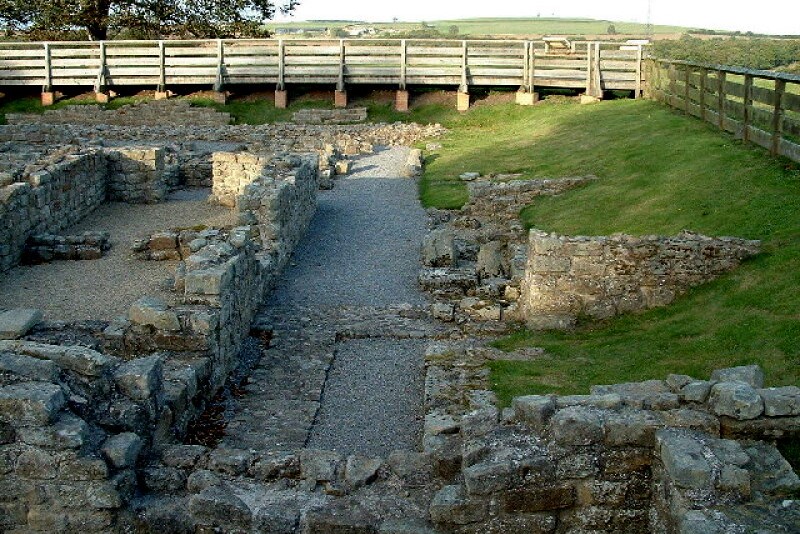 Vinovia Roman Fort
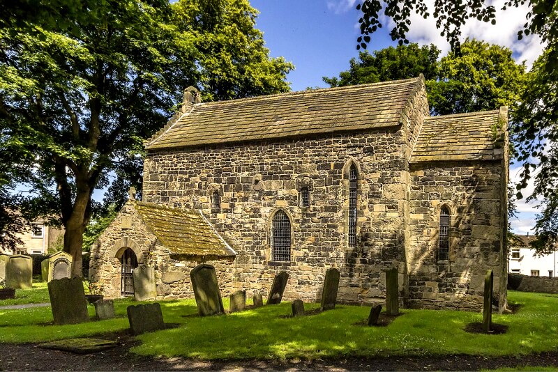 Escomb Church
You passed through Bellburn Wood, a dense broadleaved woodland to visit the Roman fort of Vinovia at Binchester. Built around AD80 to guard the main thoroughfare between York and Hadrian's wall, Vinovia was a large fortification covering 10 acres in all and with a garrison of 500 men. In recent years, the Roman site has been excavated, and on display inside a large timber structure, are the remains of the commandant's house and the heated baths; the most complete Roman bathhouse in Britain. A series of connecting rooms was heated by hypocaust - hot air from furnaces was ducted through a labyrinth of under floor tunnels to provide temperatures ranging from comfortably warm to sauna hot. The ingenious underfloor structure is remarkably well preserved. Stacks of tiles were set close together, the top tile larger than the rest and overlaid with concrete.
From Vinovia, the route leads to the River Wear, whose banks are a profusion of yellow loosestrife, monkey flower, Himalayan Balsam and Viper's Bugloss. Dippers, oystercatchers and sandpipers can all be seen along the river; and the banks are honeycombed with the tunnels of water voles.
The path goes under the elegant thirteen arch Newton Cap Viaduct, which was built in 1857 to carry the railway over the River Wear. Eventually you come to Escomb, a former pit village sheltered by a steep hill. At its heart are a circular churchyard and the smoke blackened stones of one of the most complete Anglo-Saxon churches that can be found anywhere in the world.
Escomb church supports a number of whiskered bats, which are less than two inches long and weigh less than half an ounce. The females gather here in a large breeding colony, hiding in the ancient roof space. The bats emerged to hunt for insects as dusk falls around the leafy graveyard and its lichen covered tombstones. From Escomb, the walk leads across fields and twice goes under the railway line, before rejoining the path alongside the River Wear. This leads you back to the start.
Acknowledgments: Text derived from the Out and Out Series; Discovering the Countryside on Foot. Pictures courtesy of Wikipedia.


