Kerrera, Gylen Castle, Barnabuck and Balliemore
An interesting and varied walk on an historic island
Google Maps Open Source Maps| Statistics and Files | ||
|---|---|---|
| Start: Port Kerrera | Distance: 6.5 miles (10.4 km) | Climbing: 458 metres |
| Grid Ref: NM 82959 28680 | Time: 3 hours | Rating: Moderate |
| GPX Route File | Google Earth File | About Kerrera |
| Statistics | |
|---|---|
| Start: Port Kerrera | Distance: 6.5 miles (10.4 km) |
| Climbing: 458 metres | Grid Ref: NM 82959 28680 |
| Time: 3 hours | Rating: Moderate |
| GPX Route File | Google Earth File |
Ordnance Survey Explorer Map (1:25,000)
The Walk: The West Highland town of Oban is a busy, bustling pace, even out of season. As the main ferry terminal to the Isle of Mull and many of the Inner Hebridean islands, it is more than just a popular tourist haunt. Although its popularity is well justified for its position around Oban Bay, the views, looking out towards the distant Isle of Mull, are scenically splendid and have become internationally renowned. Contributing to that scenic splendour, and protecting Oban from the vagaries of the open sea, the Isle of Kerrera stretches its green and rugged back across the mouth of the bay. It looks an attractive island, with its hummocky hills and rocky bays, and portrays an atmosphere of Hebridean tranquility.
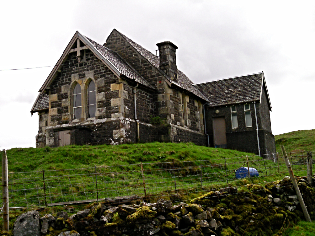 Church on Kerrera Island
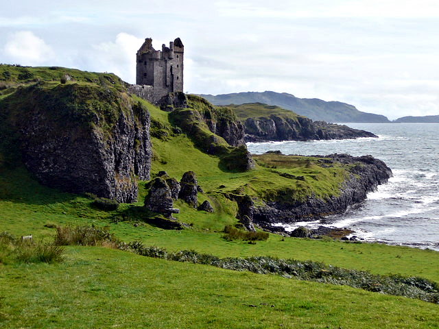 Gylen Castle
Probably because of its close proximity to the tourist trap of Oban, few visitors bother to make the short ferry crossing to savour the peace and quiet, and history of this beautiful island. Let us put that right now. The small ferry crosses the Sound of Kerrera at frequent intervals, making the planning of this walk an easy task. Arriving on Kerrera, you land at grandly named Port Kerrera which is basically a couple of houses, a church and a lone red telephone box.
Climb the hill and turn left just below the Ferry House to take a tour of the southern, and the most interesting part of the island. Soon you will reach the wide Horseshoe Bay and the Dail Righ, or the King's Field, where Alexander II of Scotland died during a royal visit in 1249. He was endeavouring to assert his rights as King in this district, at a time when this part of Scotland regarded Norway as its mother country.
As you wander on, enjoy the view over the Sound of Kerrera. In 1263 King Haakon IV of Norway arrived here with over 160 longships. The Vikings controlled most of the Hebridean waters, and this powerful host sheltered here before sailing on to be defeated at the Battle of Largs. That defeat was the beginning of the end of Viking sovereignty in the Hebrides, although even today their influence is still recognised in place names.
Further south, a subsidiary track leaves the main one and leads to Gylen Castle. Perched high on its cliffs overlooking Castle Bay and the open sea, it dominates the surroundings. This ancient tower, built in 1352 by the MacDougalls of Dunollie, was ransacked by troops under the command of one Campbell of Bragleen in 1647. Among the booty stolen was the famous 'Brooch of Lorn' - a priceless piece of jewellery that had been taken centuries earlier in 1306 by the MacDougalls from Robert the Bruce during the Battle of Dalrigh, near Tyndrum, and shored in the castle.
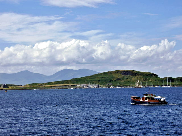 View to Kerrera from Oban Bay
 Kerrera
The remains of Gylen Castle are set in truly dramatic surroundings. Backed by a landscape of rocky outcrops it offers magnificent seaward views that extend from the mountains of Mull, on the right, to the smaller islands in the Firth of Lorne, such as Seil, Scarba and the Garvellachs, much loved by Saint Columba. Legend claims that the saint brought his mother here from Ulster, where she set up a nunnery on one of the small islands.
From beyond Gylen Castle, an ancient drove road takes you north and east around the island, past Torbhain Mor, through the old settlement of Barnabuck and back over the rugged spine of the island to Balliemore, Port Kerrera and the ferry. At one time, huge herds of cattle were landed here from Mull on their way to the trysts of Crieff and Falkirk in the south. The route taken by the cattle herdsmen and their beasts is now a fine 'green road' offering wonderful views across to Lismore, Mull and the Garvellachs, the 'Isles of the Sea' and the hills of Morvern.
Acknowledgments: Text derived from the Out and Out Series; Discovering the Countryside on Foot. Pictures courtesy of Wikipedia.


