Killiecrankie and Loch Faskally
Through the wooded Pass of Killiecrankie and around Loch Faskally
Google Maps Open Source Maps| Statistics and Files | ||
|---|---|---|
| Start: Killiecrankie | Distance: 8.6 miles (13.8 km) | Climbing: 128 metres |
| Grid Ref: NN 91599 62651 | Time: 4 hours | Rating: Moderate |
| GPX Route File | Google Earth File | About Killiecrankie |
| Statistics | |
|---|---|
| Start: Killiecrankie | Distance: 8.6 miles (13.8 km) |
| Climbing: 128 metres | Grid Ref: NN 91599 62651 |
| Time: 4 hours | Rating: Moderate |
| GPX Route File | Google Earth File |
Ordnance Survey Explorer Map (1:25,000)
The Walk: This is a wonderful walk through the Pass of Killiecrankie, around Loch Faskally and back via the waterfall known as the Linn of Tummel. This area is particularly attractive when decked with the first flush of green in spring and early summer, and again during October when the woods are ablaze with magnificent autumn colours. For the naturalist, there are many species of flora and birds to be seen, as well as roe deer and red squirrel.
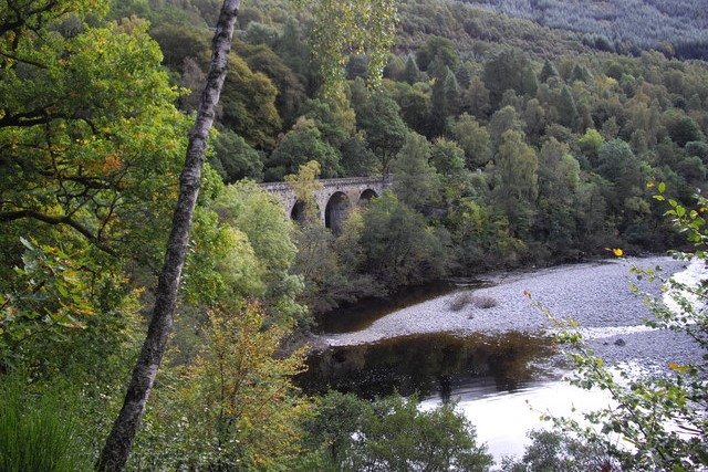 Killiecrankie Railway Viaduct
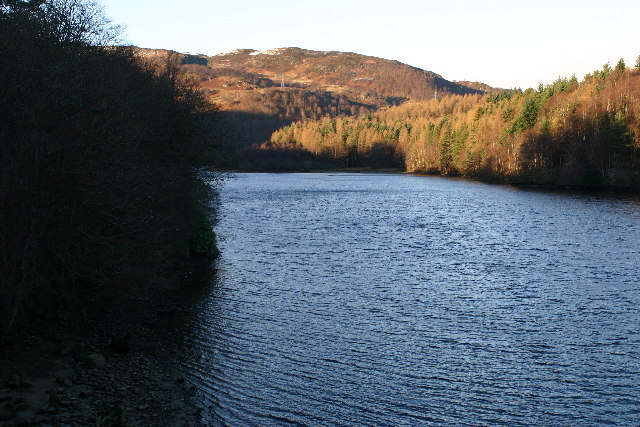 Loch Faskally
The walk starts from Killiecrankie Centre and descends into the wooded gorge of the pass. During the descent through oak and beech woodland, there is an excellent view of the Soldier's Leap, where one of the government soldiers, fleeing from the Highlanders during the Battle of Killiecrankie, managed to escape his pursuers by jumping 18 feet into the River Garry where it passes through a narrow ravine.
When the path reaches the bottom of the gorge it passes close by the railway viaduct which was built in 1873 at a cost of £5,730. The 501 foot (153 metre) long viaduct has ten arches. Each one has a 35 foot span and the maximum height from the ground to the parapet is 54 feet. A metal plaque commemorates its construction.
The path grows through the woods with the river gliding below in the deep gorge. Oak dominates this woodland but there are many other species present. Flowering plants include wood vetch, bird's nest orchid, stone bramble, melancholy thistle and giant bellflower. Wood warbler, redstart and spotted flycatcher breed in the woodland. Dipper and grey wagtail may be seen in the rocky gorge, and woodcock and great spotted woodpecker are also seen regularly.
Soon the path reaches a footbridge from which there are superb views up and down the river and over the canopy of trees below. Continuing along the east bank of the river, the path soon passes under the imposing structure of the Garry Bridge and the B8019 road high overhead. Tall pine trees mingle here with beech trees. The water from the gorge begins to emerge in a wider river valley with more open views and a large expanse of boulder and pebble beach beside the river, whose course at this point flows near the opposite bank.
Further on, the path continues through a thin band of trees along the river bank, with open fields on the left and the Clunie Power Station on the opposite bank just below the confluence of the River Garry and the River Tummel. Here there are mudflats and sandbanks where the enlarged river meanders in a curve from east to south and forms Loch Faskally.
From the shore of Loch Faskally there are excellent views up and down the loch. After crossing a bridge, there are good views of Dunmore Hill, with glimpses of Pitlochry and the rolling hills. After the farm settlement of Wester Clunie and the entrance of Clunie Power Station the loch is left behind and the valley of the River Tummel begins.
There is a good viewpoint over the Linn of Tummel but to cross the river it is necessary to continue a little further along the road by a quiet section of river to the Coronation Bridge. The woodland here is mainly deciduous, with oak and beech predominating, in some places, and a mixture of birch, hazel and alder in others. On the north bank is a stand of Scots pine.
The most natural areas of woodland have the richest ground vegetation, which includes mountain and wood melick, stone bramble, primrose, common wintergreen, goldilocks, buttercup, lily-of-the-valley and common dog-violet. Regularly seen along the river are red breasted merganser. goosander, grey wagtail and even kingfisher. The breeding woodland birds include siskin, redpoll, long tailed tit and treecreeper. Capercallie may also be seen in the heathery glades.
This section of the walk, along with the Pass of Killiecrankie, is probably the most beautiful of the whole route. On a fine autumn day, dappled golden light pours onto the path through the canopy of oak and beech, whilst fallen leaves rustle underfoot. And red squirrels may entertain you as they have been seen scampering nimbly up and down the trees.
Acknowledgments: Text derived from the Out and Out Series; Discovering the Countryside on Foot. Pictures courtesy of Wikipedia.


