Patching and Wepham Wood
A woodland walk in West Sussex countryside near Arundel
Google Maps Open Source Maps| Statistics and Files | ||
|---|---|---|
| Start: Patching | Distance: 5.8 miles (9.4 km) | Climbing: 100 metres |
| Grid Ref: TQ 08775 06500 | Time: 3 hours | Rating: Easy |
| GPX Route File | Google Earth File | About Patching |
| Statistics | |
|---|---|
| Start: Patching | Distance: 5.8 miles (9.4 km) |
| Climbing: 100 metres | Grid Ref: TQ 08775 06500 |
| Time: 3 hours | Rating: Easy |
| GPX Route File | Google Earth File |
Ordnance Survey Explorer Map (1:25,000)
The Walk: Set in some of the most beautiful countryside in south-east England, this pleasant walk combines the best aspects of West Sussex scenery - extensive views of the open, rolling farmland characteristic of the South Downs, and the quiet intimacy of natural mixed woodland which has something special to offer in every season of the year. Wepham Wood is a nature lover's delight. In springtime the ground is a carpet of bluebells. Primrose, wood anemone and lesser celandine also feature here, while Scot's pine, sycamore and English oak account for much of the woodland, together with beech and spruce. Fallow deer and grey squirrel can be seen, and badgers too. Also adders are present and active during summertime.
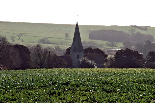 Church of St John the Divine in Patching
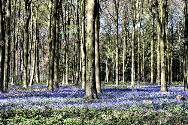 Bluebells in Wepham Wood
The walk follows woodland paths around the private estate of Angmering Park on the outskirts of Arundel. This was once part of the vast Michelgrove Estate which belonged to the Shelley family for 300 years. It was eventually sold to the Duke of Norfolk in 1828 who, legend has it, pulled down the house for fear it should be considered grander than his seat at Arundel Castle. Today, Michelgrove is a hamlet nestling between Patching Hill and Harrow Hill at the foot of the South Downs, while Angmering Park remains under the stewardship of the Duke of Norfolk.
After leaving the village of Patching, the path climbs Patching Hill, which affords glorious views of the South Downs. To the south is Highdown Hill, a much visited area not only for its iron age hill fort and Saxon burial ground but also because of the peculiar altar- like tomb of John Oliver. He was one of many Sussex eccentrics, making his own coffin years before he was ever likely to need it and keeping it under his bed. He also built his tomb 30 years before his death in 1793 at the age of 84. It was reported over 2,000 people attended his funeral.
Also the the south is Clapham village, twin to Patching, and shrine to the Shelleys of Michelgrove, for no fewer than three of their family lie here. To the south-east is Worthing and the sea, while 30 miles to the north-east is Chanctonbury Ring, a prehistoric earthwork, capped by a distinctive clump of trees.
The tiny village of Patching is tucked away amongst the trees on a road leading to nowhere. Recorded as Petchinges in the Domesday Book, its population has never been big, but its history is recorded throughout historic annals. Henry VIII visited the area, as did members of the Catholic plot to overthrow Elizabeth I. Later during the Napoleonic wars the area was turned into a war camp for French prisoners. Today, this typical English village comprises a cluster of Flint cottages around Patching Church. St John the Divine church, built around 1200, is beautiful in its simplicity, with early English lancet windows and a 15th century font. The Victorian pulpit has a carved panel of birds and foliage and there is an exceptionally fine screen at the back of the altar with over 40 carved figures on it.
Acknowledgment: Text derived from the Out and Out Series; Discovering the Countryside on Foot. Pictures courtesy of Wikipedia.


