Jevington, Lullington Heath National Nature Reserve and Litlington
A hilltop walk across the ridges and along the valleys of the South Downs
Google Maps Open Source Maps| Statistics and Files | ||
|---|---|---|
| Start: Jevington | Distance: 5.9 miles (9.4 km) | Climbing: 294 metres |
| Grid Ref: TQ 56268 01389 | Time: 3 hours | Rating: Moderate |
| GPX Route File | Google Earth File | About Lullington Heath |
| Statistics | |
|---|---|
| Start: Jevington | Distance: 5.9 miles (9.4 km) |
| Climbing: 294 metres | Grid Ref: TQ 56268 01389 |
| Time: 3 hours | Rating: Moderate |
| GPX Route File | Google Earth File |
Ordnance Survey Explorer Map (1:25,000)
The Walk: The chalk downs of southern England are a fretwork of rounded ridges and sinuous dry valleys carved out during the last ice age more than 12,000 years ago. This walk crosses several of these ridges and valleys, taking in a variety of terrain including tranquil pastures, shady woodland and an unusual chalk heath that is now Lullington Heath National Nature Reserve. The hilltops offer broad views over the downs, the sea and surrounding villages, while the valleys are alive with wild flowers, butterflies and songbirds. The tiny villages of Jevington and Litlington are perfect examples of local flint architecture, each with its ancient church, while the hills between them still bear the mark of the prehistoric farmers who cleared the downs for agriculture and created the Sussex landscape we know today.
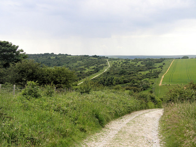 Lullington Heath
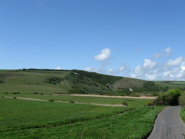 View to Litlington White Horse
The South Downs are dotted with sturdy little churches dating back to Norman and even Saxon times, but many are not quite as old as they look. Until quite recently Sussex was a remote county cut off from the mainstream of architectural fashion, and the local masons were still building churches in the Anglo-Saxon style several decades after the Norman Conquest. St Andrew in the village of Jevington could well be such a church, although some scholars have dated the massive tower as early as AD 900. Whatever its date of construction, it is well worth a visit, if only to see the rare Saxon sculpture of Christ destroying Evil, built in the north wall of the church. A thousand years before the church was built, the hills above Jevington were being cultivated by Iron Age farmers. The boundaries of their square or rectangular fields are still visible in many places where centuries of ploughing cause the thin chalk soils to slip downslope and pile up against fences that have long since vanished from sight.
From the 18th century the fine chalk grassland was used for grazing sheep, but providing water was always a problem. The graziers solved the problem by building 'dewponds' such as Winchester's Pond which is visited during the walk. These dish-shaped pools were lined with clay to prevent rainwater seeping away. Many cracked over time and are now dry but Winchester's Pond has been restored and is now a haven for wildlife, particularly dragonflies. The River Cuckmere has carved its way right through the chalk downs to the sea, creating a steep sided valley adorned with the Litlington White Horse. The river winds across the flood meadows of the valley floor in a superb series of looping meanders, caused by the river eroding away the outsides of each bend while dumping mud and gravel on the inside. The most spectacular meanders are close to the hill where the Litlington White Horse is carved and near the mouth of the river, where the Litlington road meets the A259. Deep Dene is a dry valley scoured out by meltwater during the ice ages. Today water simply drains away through the chalk, but 12,000 years ago conditions in Sussex resembled those found today in Arctic Siberia, and the chalk was permanently frozen. When the deep winters snows melted in summer the water could not drain away so it rushed downslope to the sea in torrents, etching deep valleys such as that of the River Cuckmere.
Litlington is a perfect little downland village, perched on the bank of the River Cuckmere, with flint cottages, an ancient farmhouse, a pretty church and a fine rectory. Handsome Clapham House was once the residence of Maria Fitzherbert, whom the future George IV married in secret. Hidden tantilising behind a screen of trees is Charleston Manor, called 'a perfect house in a perfect setting'. Here there are magnificent gardens and an impressive 15th century barn. There is also a Norman dovecote to enjoy.
The nature reserve of Lullington Heath is a treasure trove of attractive plants and wildlife. The species here are influenced by the chalkland soil. Chalk is almost solid lime which affects the types of plants which grow on it. These normally include thyme, horseshoe vetch and birds-foot trefoil. Lullington Heath is different however, since its thin soils are actually acid. This is because the chalk is blanketed by a shallow layer of red clay with flints that effectively insulates the soil from the influence of the lime. As a result you may come across plants typical of acid heathland such as heather, woodsage, tormentil and gorse. Chalkland flowers such as dropwort, scabious and salad burnet, which are able to penetrate the clay to reach the chalk beneath, as well as chalk scrub specialists such as hawthorn, blackthorn and the wayfaring tree make for a mixed delight of species. This strange combination attracts a colourful variety of butterflies, including the chalkhill and Adonis blue, marbled white and grayling. The scrub provides nesting sites for stonechats, whitethroats, yellowhammers and linnets, while skylarks soar overhead.
Acknowledgment: Text derived from the Out and Out Series; Discovering the Countryside on Foot. Pictures courtesy of Wikipedia.


