Oxen Hoath, Rats Castle, Old Soar Manor, Plaxtol Spout and Hamptons Mills
A walk in the Greensand hills of the Bourne valley
Google Maps Open Source Maps| Statistics and Files | ||
|---|---|---|
| Start: Dene Park Car Park | Distance: 8.1 miles (13.0 km) | Climbing: 215 metres |
| Grid Ref: TQ 60626 51029 | Time: 4 hours | Rating: Moderate |
| GPX Route File | Google Earth File | Greensand Ridge |
| Statistics | |
|---|---|
| Start: Dene Park Car Park | Distance: 8.1 miles (13.0 km) |
| Climbing: 215 metres | Grid Ref: TQ 60626 51029 |
| Time: 4 hours | Rating: Moderate |
| GPX Route File | Google Earth File |
Ordnance Survey Explorer Map (1:25,000)
The Walk:
The River Bourne rises below the North Downs and cuts through the Greensand Hills on its way south to the Medway Valley. There are glorious views from the hilltops. Ancient farms and manor houses occupy sites carved out of the forests before the Norman Conquest, and deep holloways testify to centuries of foot and horse traffic between scattered hamlets. Two medieval farms are now pubs where walkers can eat, drink and rest beside a logfire in winter, or sit outside in the summer months.
The walk begins in woodland at the car park in Dene Park, which in the Middle Ages was part of the hunting chase of North Frith belonging to the Clare family of Tonbridge Castle. The boundary stone marks the meeting point of the three parishes of Shipbourne, Hadlow and West Peckham. The path runs along the top of an earth bank, six feet high in places, which mark the old boundary between Clare lands and lands belonging to the King. In medieval times, a fence made of oak pales ran along the top of the bank. It was a substantial boundary marker that also served to keep deer within the chase.
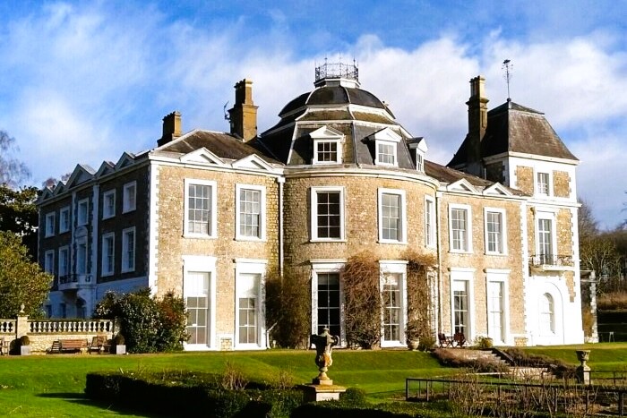 Oxon Hoath House
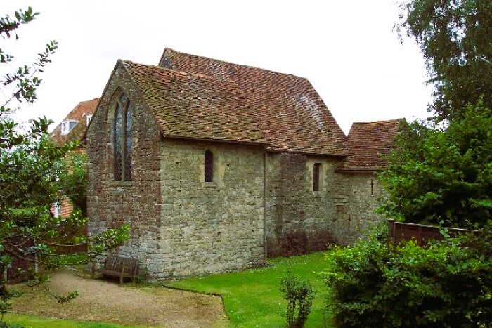 Old Soar Manor
The coppiced chestnut wood on the left is called Clearhedges, a corruption of 'Clare' hedges and an example of early boundary definition. Foxgloves and bluebells carpet the ground in spring and in Frith Wood standard oaks grow among yews, beeches, hazels and silver birches. Honeysuckle and violets grow beside the path and woodpeckers can be heard hammering at the nearby trees.
Where the path reaches the field edge, the tower of Hadlow Folly, 170 feet high, comes into view. This is all that remains of a 19th-century Gothic castle. The story goes though the tower was built in an attempt to see the sea.
In the valley bottom is the site of a medieval moated farmhouse. The badly drained nature of the land was used to advantage when the farmer constructed a large square moat around his house using a tributary of the River Bourne. The moat kept his cattle in, kept marauders out, provided fish for the table, and drained water away from the floor of the house.
The original exit from the fields around the moat to the road can be found in the hedge. It is an iron swing gate designed to prevent the passage of animals. The country name was a 'Penny Please Gate'. Country children used to stand in the curve and demand money from adults to let them through. Another name was a kissing gate.
The path ascends through the old Deer Park of Oxen Hoath Manor. There has been at least three houses on the site. The present one is by the architect Slavin. To the left are walled kitchen gardens with a formal walk leading to ornamental gates. The ancient cedars lining the drive were devastated by the 1987 hurricane. At this point, a diversion to the Artichoke pub can be made.
Gover Hill is managed by the Woodland Trust. It is 500 feet high and there are magnificent views over the Bourne valley. The chestnut copses on the hill are famous for bluebells and primroses.
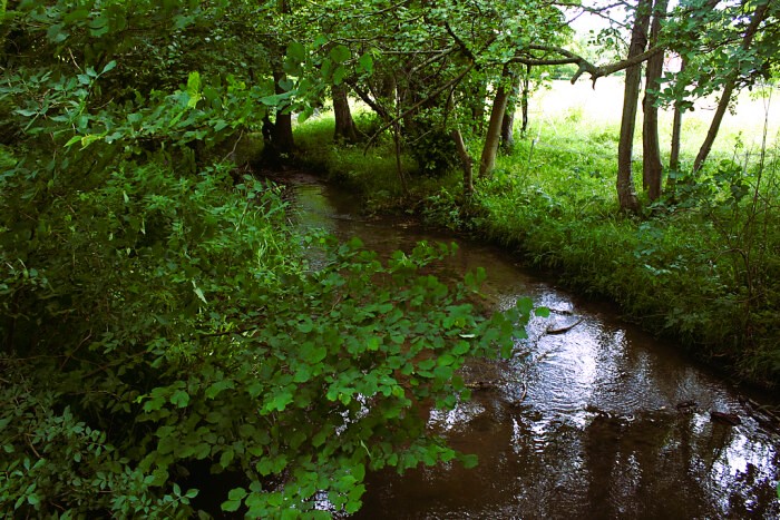 River Bourne at Plaxtol Spout
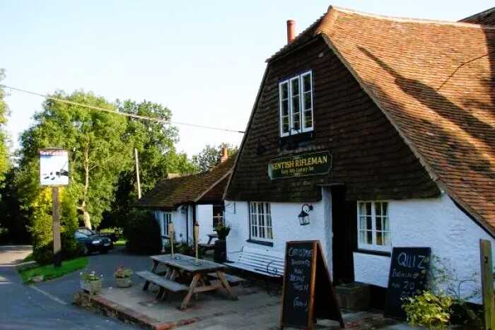 Kentish Rifleman, Dunk's Green
Ancient farmsteads lie in sheltered spots on the valley side below the hill. Rats Castle is a 15th-century house that has its timber frame encased in local ragstone; brick and tile in the 17th-century by Stephen Chilman, whose initials are on the gable. In the 19th-century it decayed and its uncomfortable name was given to it by workmen who lived there while they did building work on the nearby mansion of Hamptons.
From here, the route goes up and down two holloways. In 1495 they were described as 'King's Highways'. They have escaped the tarring of the 20th and 21st centuries and remain to show us what all the original roads in the area were like.
Broadfield Farm is the 17th-century house onto which the new owner, Robert Baldwin, put a new front in 1700. The twisted rope decoration to the string course at first floor level is an unusual feature.
At Old Soar Manor, the stone built private living quarters of a medieval knight have survived from 1290. An exhibition in the chapel crypt explains the building. The brick farmhouse attached is a private house that occupies the site of the great hall of the medieval manor.
This part of the valley is rich in Roman remains. A Romano-British villa was excavated within site of Old Soar in the 1980s and the site of another large villa is shown on the map south of Plaxton Spout near Allen's Farm. Early evidence for the literacy of a Roman workman was found when a tile came to light on which the tile maker had scratched his name - Cabriabanti. The tile is now in Maidstone Museum.
Every road crossing of the Bourne was once the site of a mill for corn or cloth filling or latterly for paper. Roughway Mill was connected with the paper industry. The waterfall at Hamptons Mill reminds us of the power of the small streams that kept the mill wheels turning into the 20th century. Remains of the stone mill lie on the bank. A short riverside walk and another path through Clearhedges completes the walk by arriving back at the boundary stone.
Acknowledgment: Text derived from the Out and Out Series; Discovering the Countryside on Foot. Pictures courtesy of Wikipedia.


