Godalming, Peper Harow, Shackleford and Norney
A riverside walk through hamlets and past an historic school
Google Maps Open Source Maps| Statistics and Files | ||
|---|---|---|
| Start: Godalming | Distance: 6.4 miles (10.3 km) | Climbing: 148 metres |
| Grid Ref: SU 97109 44027 | Time: 3 hours | Rating: Easy |
| GPX Route File | Google Earth File | About Godalming |
| Statistics | |
|---|---|
| Start: Godalming | Distance: 6.4 miles (10.3 km) |
| Climbing: 148 metres | Grid Ref: SU 97109 44027 |
| Time: 3 hours | Rating: Easy |
| GPX Route File | Google Earth File |
Ordnance Survey Explorer Map (1:25,000)
The Walk:
Godalming, the town in which this walk commences, has plenty to attract the visitor. On the walk, you will come across many points of interest with histories going back several hundred years. These include ancient bridges built by monks to stand the test of time, and an estate village which creates a picture of life as it would have been 250 years ago.
The original St Peter and St Paul Church was recorded in 1086 as part of the estate of Rannulf Flambard, who came from Normandy to join the court of William the Conqueror. The present church was built on the same site as the original in the 1860's. During excavations, the foundations of a chancel and nave revealed a total of eleven skeletons buried within the walls.
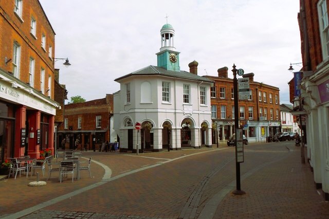 The Pepperpot in Godalming
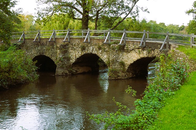 Eashing Bridge on the River Wey
Westbrook Place was the home of Sir Theophilus Oglethorpe in the 17th century. His son, General James Oglethorpe, was the founder of the state of Georgia in the United States.
Charterhouse School, founded in London in 1611, moved to Godalming in 1872. The impressive buildings greatly enhanced the town and caused it gradually to expand to accommodate the new residents that were attracted here.
The hamlet of Upper Eashing consists of farmhouses that have now become desirable modern residences. The road through the hamlet leads down to the famous double Eashing Bridges.
There are several of these bridges over the River Wey between Guildford and Farnham. Built as a series by the monks of Waverley Abbey in the 13th century, they are now in the care of the National Trust, and long may they remain as a reminder of how well our ancestors built with none of the technological advantages that we can take for granted today. Notice the well-shaped cutwaters taking the flow of the Tide; they are rounded on the downstream side to prevent eddying and eventual wearing down of the piers.
A resident of Lower Eashing from a century or two past would probably find that it looks similar now to the way it did 200 years ago. There has been a mill here since the Norman Conquest, and if you look carefully as you walk through, you will find evidence of the site of the former Smiths forge. A modern bridge carries the A3 over the river a quarter mile below Eashing. During its building, skeletons were found with a Roman hairpin lying near the head of one of them.
Located a little way from the village itself is Shackleford Church. Its magnificent spire was built in 1865 by Sir George Gilbert Scott.
Just before arriving at Peper Harow, you pass a group of cedars of Lebanon which were planted as seedlings in 1735, when the estate village, as you see it today, was formed. The present mansion, now converted to luxury apartments, was built in 1775 on the site of the original. As you walk up the lane, notice the 17th century granary through the gateway on the right. It was raised on stilts to prevent attacks by rodents.
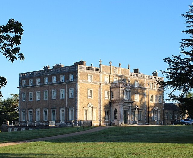 Peper Harow House
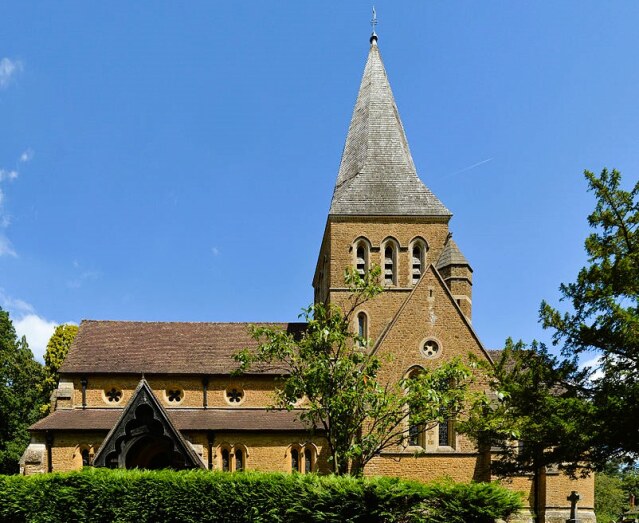 St Mary's Church, Shackleford and Norney
In the village of Shackleford, there are some fascinating old cottages in the vicinity of the village shop, and one has a serpentine wall similar to those usually found in Suffolk.
A little further along the walk are some steps that were built by volunteers from one of the county's leading rambling groups, the Surrey County Walkers, as a contribution to countryside conservation. This once quite trecherous path though, can now be used all year through.
Canoeists are the only ones easily able to negotiate the River Wey at this point. The navigable portion, which is known as the Godalming Navigation, was built two centuries ago as a canal. It runs from the town bridge for 4.5 miles to Guildford. Here it joins the Wey Navigation and continues for another 14.5 miles to link with the River Thames at Weybridge. The canals entire length is in the care of the National Trust.
On the approach to Godalming, Boarden Bridge crosses the River Wey. This low brick structure is over 250 years old and is the town's oldest surviving bridge.
The Cloister is dedicated to the memory of John George (or Jack) Phillips. When the Titanic hits an iceberg on its maiden voyage in 1912, it was Jack from neighbouring Farncombe who, as Chief Wireless Operator, stated his post and sent distress signals until he too succumbed to his fate in the icy depths of the Atlantic Ocean.
Acknowledgment: Text derived from the Out and Out Series; Discovering the Countryside on Foot. Pictures courtesy of Wikipedia.


