Pangbourne, Whitchurch-on-Thames and Mapledurham
A walk around the part of the Thames responsible for the creation of 'The Wind in the Willows'
Google Maps Open Source Maps| Statistics and Files | ||
|---|---|---|
| Start: Pangbourne | Distance: 7.6 miles (12.2 km) | Climbing: 134 metres |
| Grid Ref: SU 63409 76426 | Time: 3-4 hours | Rating: Easy |
| GPX Route File | Google Earth File | About Pangbourne |
| Statistics | |
|---|---|
| Start: Pangbourne | Distance: 7.6 miles (12.2 km) |
| Climbing: 134 metres | Grid Ref: SU 63409 76426 |
| Time: 3-4 hours | Rating: Easy |
| GPX Route File | Google Earth File |
Ordnance Survey Explorer Map (1:25,000)
The Walk: This walk gives a brief introduction to the area where the author Kenneth Grahame lived during the latter part of his life. The route starts by crossing the River Thames and overlooks the quiet stretches of river which may well be those described in his famous book, 'The Wind in the Willows'. The walk continues along lanes and passes the grand house of Mapledurham, which may have been the inspiration of Toad Hall, the home of Grahame's flamboyant character, Mr Toad.
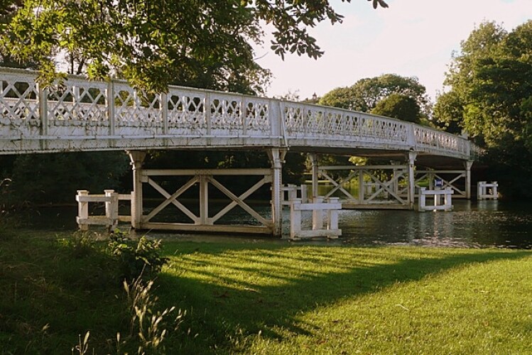 Whitchurch-on-Thames Toll Bridge
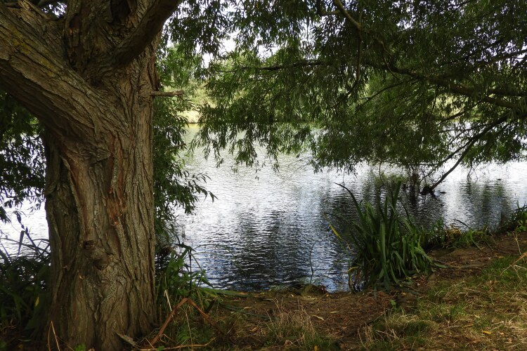 River Thames between Whitchurch and Mapledurham
The walk starts in Pangbourne, where Kenneth Grahame and his wife lived after the death of his son. The couple lived quietly at Church Cottage, close by the church in Pangbourne. After looking at the outside of the privately owned house, the walk passes through the centre of Pangbourne and leads to the river, the Toll Bridge and to Whitchurch-on-Thames. The view upstream is of the lock, which is in constant use during spring and summer. The distant countryside seen downstream forms the major part of the walk. The present toll bridge was built in the 1920's and is the third bridge on the site. The original was constructed under an Act of Parliament in 1792. In the 1990's a further Act has enabled permit increases in the tolls and alterations have been made to the general terms and conditions placed on the private company that operates and maintains the bridge.
There is a splendid view of, and access to, the old part of Whitchurch in his beautiful setting by the Mill Pond. The Mill is mentioned in the Domesday Book and the whole scene of the mill, the nearby cottages, and the backdrop of the church, appear to have been almost undisturbed for centuries. The first church was probably constructed here over 1,000 years ago. It would have been timber-framed and the clay used for its daub would have contained a lot of chalk - thus giving the village its descriptive name of Whit(e) church.
The walk continues up the High Street past the Ferryboat Inn. The left hand side of the High Street was once lined with 19 Elm trees and local miscreants were sometimes chained or handcuffed to the trees as a public spectacle for rowdy or unruly behaviour. The local gaol and fire station were immediately opposite the trees.
The walk continues by turning into Eastfield Lane just before the Greyhound public house. The fields along Eastfield Lane form part of the floodplain, but residential development has taken over the land. At the end of the lane the walk reaches the village school. It follows the path between the cricket field and the allotments in their peaceful beechwood background settings until it meets the Hardwick Road, which in turn leads to the Hardwick estate. Numerous badger tracks across this section of the walk.
The view now opens out to a pastoral scene as the walk passes the old farmhouse of Bozedown Farm. About a mile past the farm, the walk reaches the back entrance gates to the Hardwick estate. The fields on the right are used for organic farming and the lane on the right, Sheepwash Lane, is one of only three access points to the river for the residents of this riverside village. The bridle road leads past the entrance lodges; The Stud and Hardwick House, to approach and reach Mapledurham, a Thames-side village.
All the animals mentioned in the 'Wind in the Willows' can be found on this area. There is a large population of badgers and foxes are frequently seen on their forays to and from the river. The river provides a feeding ground for swans, herons and the Canada Geese that congregate in the riverside fields before engaging in their fly-past displays. The local farms are mixed farms, and the land alternates between arable and pasture.
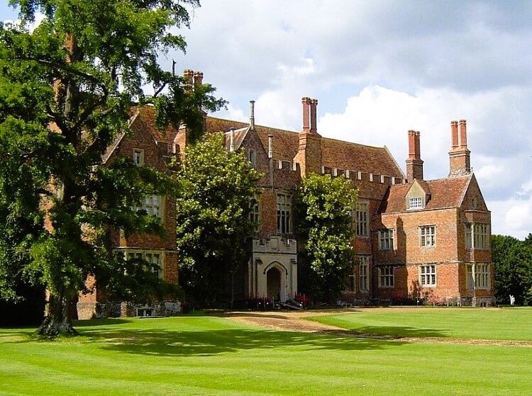 Mapledurham House
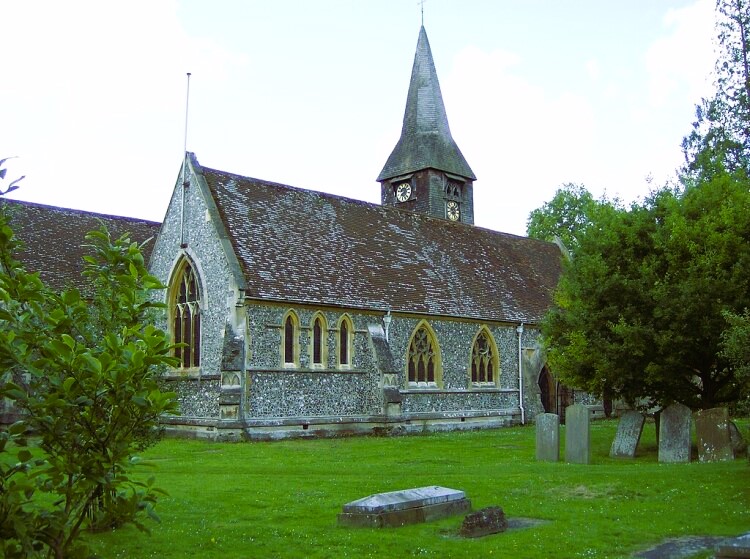 St Mary's, Whitchurch-on-Thames
The walk continues into the Mapledurham estate. The village of Mapledurham is isolated and little, if any, development has taken place. The Almshouses, the village houses, the church and the grand Mapledurham House, in their general unspoiled environment, are extremely pleasing. A perfect example of a manorial settlement dating back to the Middle Ages. The name of the village probably means 'a maple tree enclosure'. The Almhouses were built under the terms of the will of Sir Charles Lister and they date back as far as 1614.
The general area of Mapledurham is mentioned in John Galsworthy's 'Forsyth Saga', and in 1976 the village was used in the film 'The Eagle has Landed' which starred Michael Caine and Donald Sutherland. The mill and church feature prominently in the film.
On the return walk from Mapledurham, the walk turns up into the beechwoods, pleasant at all times of the year and home for many animals, including small muntjac deer. At the top on the left is a deep pit known locally as the 'Bear Pit'. Here the path flattens and leads straight out of the woods to Path Hill Farm. Immediately after the farm, the walk turns down a private road to reach 'The Baulk', a private house with two steeples. The local story tells how an eloping couple were baulked in their attempt to get married when they mistook the house for a church.
The path from the Baulk leads downhill and overlooks the Thames valley, the route through the fields and along the road used earlier. To the far right, the edge of an Iron Age Fort oversees the valley floor.
The high level footpath continues in front of all the houses on Hillside and passes the flint School House along what was probably the original village road. It meets the main road which leads into the top part of the village. The road returns to the Toll Bridge, but the walk will divert just before the Ferryboat Inn to St Mary's Church and churchyard. The church nestles alongside the cottages and the mill side. The parish and poor registers of the church have been well maintained and date back to the 16th century. The walk now emerges by the side of the mill pool, then returns to the village of Pangbourne.
Acknowledgment: Text derived from the Out and Out Series; Discovering the Countryside on Foot. Pictures courtesy of Wikipedia.


