Lamberhurst, Owls Castle, The Down and Scotney Castle
Through valleys and meadows to castle ruins in a landscaped gardens
Google Maps Open Source Maps| Statistics and Files | ||
|---|---|---|
| Start: Lamberhurst | Distance: 5.4 miles (8.7 km) | Climbing: 126 metres |
| Grid Ref: TQ 67608 36082 | Time: 3 hours | Rating: Easy |
| GPX Route File | Google Earth File | About Lamberhurst |
| Statistics | |
|---|---|
| Start: Lamberhurst | Distance: 5.4 miles (8.7 km) |
| Climbing: 126 metres | Grid Ref: TQ 67608 36082 |
| Time: 3 hours | Rating: Easy |
| GPX Route File | Google Earth File |
Ordnance Survey Explorer Map (1:25,000)
The Walk: The village of Lamberhurst lies in the valley of the River Teise. This river once separated Kent from Sussex until a 19th-century revision moved the county boundary a couple of miles to the south. Scotney Castle lies in another valley, a little to the south, beside the River Bewl, Between village and castle, rises a lovely stretch of high ground from which there are extensive views.
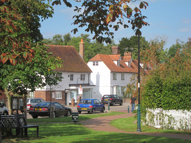 The Broadway, Lamberhurst
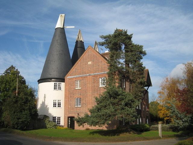 Furnace Nill Oast House
The Teise powered the hammers of the Gloucester Furnaces, once one of England's largest foundries. It certainly existed in the 14th century, and it was later to produce cannons for English galleons and firebacks for English houses. In 1710 the Gloucester Furnace, so named to honour the visit by the Duke of Gloucester, provided iron railings and gates to surround St Paul's Cathedral at the cost of £11,000. They stood for over 200 years and in 1976 a section of the railings was returned to Lamberhurst by the Dean and Chapter.
The walk follows the River Teise from the car park next to the Chequers Inn in Lamberhurst, beside which the St Paul's railings are set into the wall. After about a mile or so of easy walking, the site of the old Gloucester Furnace is reached. Furnace Mill sits on the rise beyond a lovely tranquil water meadow beside the river. At one time, the stream was diverted to power the foundry. Close by, iron ore was found in the local sandstone, and the furnaces were fuelled by wood from abundant local forests. In the 18th century, fierce competition from the coal fired foundries of South Wales and Yorkshire ended the Wealden iron industry and the Gloucester Forge closed in 1765.
Shady Lane runs southwards to the lovely lake at Peppermills and Furnace Lane brings you to Furnace Farm, where a farmhouse tea can be enjoyed in the garden in summer.
Opposite Furnace Farm, a field path leads to a pretty bluebell wood and into one of the many little valleys carved by streams in the soft sandstone. When the path joins a byway, it passes an extensive chestnut coppice named Owls Castle. Nearby is Owls Castle Oast House.
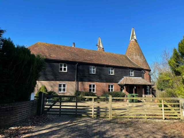 Owls Castle
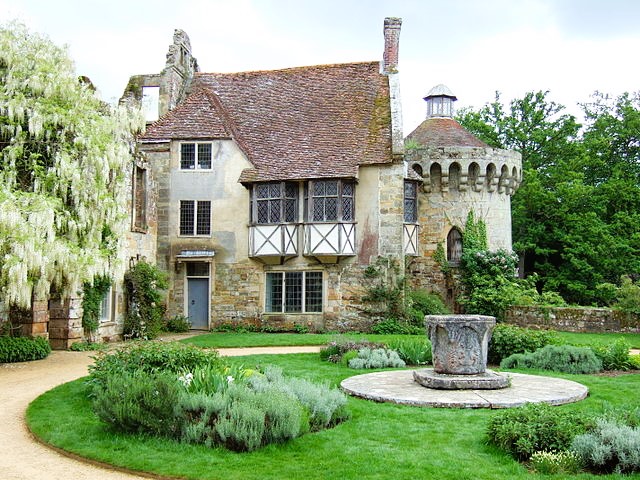 Scotney Castle
Soon, Scotney Park is entered, and a drive opens into the secluded valley of the River Bewl. To the right is Kilndown Wood and ahead to the left stands the 'new' Scotney Castle. Hidden by trees is the romantically situated 'old' Scotney Castle, its moat fed by the Sweet Bourne. A path from the castle drive rises through woods and passed a perfect picnic spot by the lake. It then ascends the slope to reach a thoughtfully located seat.
Scotney Castle's early history is obscure, but there appears to have been a watermill on the site in medieval times. The castle probably takes his name from the combination of 'scot', a payment and 'ey', an island - the castle being built on one of two islands in the River Bewl. The river was diverted when the moat was formed. The ruins that remain are of the castle built by Roger de Ashburnham in 1878-80 and bear a resemblance to Bodiam Castle in East Sussex. This might not be a coincidence, Sir Edward Dalyridge, who built Bodiam, served with Ashburnham on the commission 'de Wallibus et Fossibus' (walls and dykes) for the Romney Marsh area.
Scotney was built primarily as a residence, but it was strengthened because of the incursion made by French pirates at the time. In 1377, Rye and Winchester had been sacked and Hastings burned. In fact, Scotney never was besieged. It did, however, provide a secret refuge for seven years for a hunted Jesuit priest during the religious intolerance of the late Tudor period.
A house built adjoining the tower in 1580 survives today. It contains a fine oak showcase.
Edward Hussey established the Scotney estate between 1778-92. It was his descendants who, in 1837, embarked upon a scheme to build a new castle higher up the hill and quarried the stone on site. The garden was landscaped and planted with flowering trees, most notably rhododendrons and the azaleas.
Straight ahead in the middle distance is Lamberhurst Church, isolated from the village and standing in open countryside. Close by the church is Court Lodge, built tradition has it, with the stones of Scotney's missing towers. To the right in the far distance, yet prominent, is the hilltop village of Goudhurst. Several stiles in the westward bound field path now leads you back to the car park in Lamberhurst.
Acknowledgment: Text derived from the Out and Out Series; Discovering the Countryside on Foot. Pictures courtesy of Wikipedia.


