Bucklebury Common, Bucklebury and Stanford Dingley
Through broad-leaved woodland and alongside the River Pang
Google Maps Open Source Maps| Statistics and Files | ||
|---|---|---|
| Start: Car Park | Distance: 5.5 miles (8.9 km) | Climbing: 96 metres |
| Grid Ref: SU 55881 69328 | Time: 3 hours | Rating: Easy |
| GPX Route File | Google Earth File | About Bucklebury |
| Statistics | |
|---|---|
| Start: Car Park | Distance: 5.5 miles (8.9 km) |
| Climbing: 96 metres | Grid Ref: SU 55881 69328 |
| Time: 3 hours | Rating: Easy |
| GPX Route File | Google Earth File |
Ordnance Survey Explorer Map (1:25,000)
The Walk:
The walk is mainly on footpaths over fields and through broad-leaved woods, and includes visits to two delightful villages. The walk starts in the middle of woodland, of a type which is to feature for much of the way. Oak, Beech and Birch dominate, while the forest floor carries a dense covering of ferns, amongst which a variety of sometimes large and colourful fungi can be seen.
At the beginning, the track is broad and gravely, but soon changes to a narrower green path through the trees. In general, the woodland is quite dense, but every now and then it opens out into attractive glades. At the junction of the tracks is a small thatch and timber cottage.
The track leaves the woodland temporarily to give wide vistas over tree covered hills and fields of grain. Although out of the wood, the path is still shaded by oak trees and cottages can be glimpsed, almost lost from sight amongst the greenery. For a while. crop fields, their margins bright with poppies, adjoin the path before it dips into a dense copse.
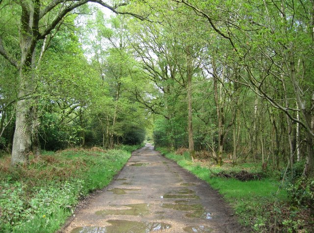 Bucklebury Common
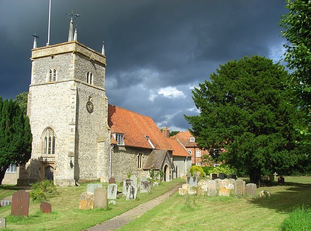 Bucklebury Church
The tiny area of woodland seems almost to be bursting with wildlife. Squirrels rush around the branches and the copse echoes with bird cries. Apart from the ubiquitous wood pigeon, you can spot jay, nuthatch, the tiny goldcrest and a great many more species. The birds flit to and fro across the tree shaded path while partridge and pheasant can be glimpsed in the adjoining fields.
Beyond the copse, trees have been felled to create a rough area of wasteland where a variety of plants flourish, including thistles, which grow well above head height. The path dodges back into a narrow lane bordered by dog roses that brings you down to the road and the village of Bucklebury, close by the church. The latter, with an attractive timber framed house bordering the churchyard, is worth a detour.
The walk now follows the road as it winds and twists through the little village, past the 'Victory Room' at the edge of the cricket field, the building of the old post office and the very attractive Riverside Cottages, with old and very tiny lattice windows. Here the River Pang is no more than a gently trickling stream, but it will grow to become an important tributary of the Thames at Pangbourne.
The road continues its circuitous way through the village, crossing the Pang on a simple brick bridge before heading off towards an impressive stand of pine at the crossroads, where it turns to follow a route parallel to the Pang. The riverside fields are full of pigs foraging, while close by the water is an immense wooden barn with prominent porches.
The walk now turns off the road and back onto footpaths, starting with a deep sunken lane with a bank topped by a thick set thorn hedge on one side and mature trees on the other. This lane leads down to the Pang, which at this stage is still little more than the winding stream overhung with willow trees. The lane follows the stream before cutting across the fields towards Stanford Dingley. It goes through another patch of woodland, then heads across a field where the bumps and hollows suggest clay has been dug out for brick making for the local buildings. It then arrives at the road and the church at Stanford Dingley.
The church is rather more conventional than that Bucklebury, its main body is flint with a brick extension and it has a timber tower and slate-clad steeple. The churchyard is notable for a number of sweet chestnut trees. The church is a Grade I listed building. Only the moat of the old neighbouring manor house now remains, out of site behind the walls of Manor Farm.
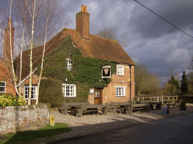 The Bull Inn, Stanford Dingley
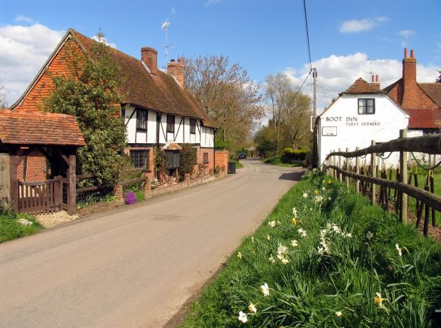 Stanford Dingley
Stanford Dingley turns out of many buildings of great character and charm. The first building of note is the 15th-century Bull Inn, which looks out across the village green. It has an unusual sign - on one side it has the conventional head of a bull on view, but the reverse shows only its backside.
The village houses show a mixture of building materials. There are bricks often set in a diamond pattern with blue headers alternating with dark red stretchers to create a checkerboard pattern. There is also weatherboarding and walls hung with tiles in intricate patterns.
From the bridge over the river, you can see the converted village mill, but the grandest houses appear after you have turned the corner towards Bucklebury Common. A timber frame cottage stands next to a thoroughly urbane Georgian House. The name Garden House is amply justified for the formal gardens across the road would not disgrace the grandest country mansion. The house has a formal 18th-century frontage, but the gable ends have tiles hung in regular but complex patterns. Beyond the 18th century Boot Inn is an attractive timber-framed house with a traditional cottage garden. But beyond that is the grandest of all the village houses, the Old Rectory. Those with a taste for English domestic architecture may well wish to wander on the outskirts of the village where there are still more delights to discover, but the walk itself turns off to return to footpaths, fields and woods.
It is said that the parish of Bucklebury has more footpaths than any other in England, and meeting the mazes of paths, this is not difficult to believe. Bucklebury Common, where many paths crisscross each other, is recorded in the Domesday Book as Borgeldeberie Hundred (the land of Burghild's Fort). It was once a royal hunting ground, and in 1644 some 20,000 Parliamentary troops camped out in the woods here before the Second Battle of Newbury.
Today, this wooded area is enjoyed for peaceful recreation. It remains predominantly oak and beech, and a large area of young trees along the way provide evidence of the efforts being made to preserve this ancient woodland. The common is enjoyed by many long distance hikers and dog walkers. The path stays in the confines of the woods until the end of the walk.
Acknowledgment: Text derived from the Out and Out Series; Discovering the Countryside on Foot. Pictures courtesy of Wikipedia.


