Brading Marshes Nature Reserve, Bembridge Windmill and Culver Down
Exploring the varied scenery of a corner of the Isle of Wight
Google Maps Open Source Maps| Statistics and Files | ||
|---|---|---|
| Start: Brading Church | Distance: 7.2 miles (11.6 km) | Climbing: 204 metres |
| Grid Ref: SZ 60622 87305 | Time: 3 hours | Rating: Moderate |
| GPX Route File | Google Earth File | About Brading |
| Statistics | |
|---|---|
| Start: Brading Church | Distance: 7.2 miles (11.6 km) |
| Climbing: 204 metres | Grid Ref: SZ 60622 87305 |
| Time: 3 hours | Rating: Moderate |
| GPX Route File | Google Earth File |
Ordnance Survey Explorer Map (1:25,000)
The Walk:
This walk of contrast on the Isle of Wight begins in an historic town, follows a causeway over marshland into farms and oak woods, then returns via a clifftop coastal path and chalk downland. On the way, you pass old buildings, modern holiday bungalows and military installations.
Today, Brading seems little more than a village, but it was once known as 'Ye Kynge's Towne of Brading' and was a bustling busy port on the River Yar. It has only been since 1880, when the Yar was dammed at its estuary in Bembridge, that Brading took on its current quiet aspect, sheltering beneath tree covered downs to the west and looking out over the marshland to the east.
It is a town steeped in history. Just to the south are the remains of a substantial Roman villa, famed for its mosaics. There was a Saxon settlement here, and Brading was already a busy port in AD7O4, when Saint Wilfred landed here to bring Christianity to the Isle of Wight. He built a church on the site of a pagan temple on the ridge at the north of the town.
Today the site is occupied by the 12th century Church of St Mary, the largest medieval church on the island. It is distinguished by a porch-tower which stands on arches so that a processional way could be made around the church without leaving consecrated ground, and inside, by the monuments in the Oglander Chapel, dedicated to the family who lived in Nunwell House, just west of the town, until late the last century.
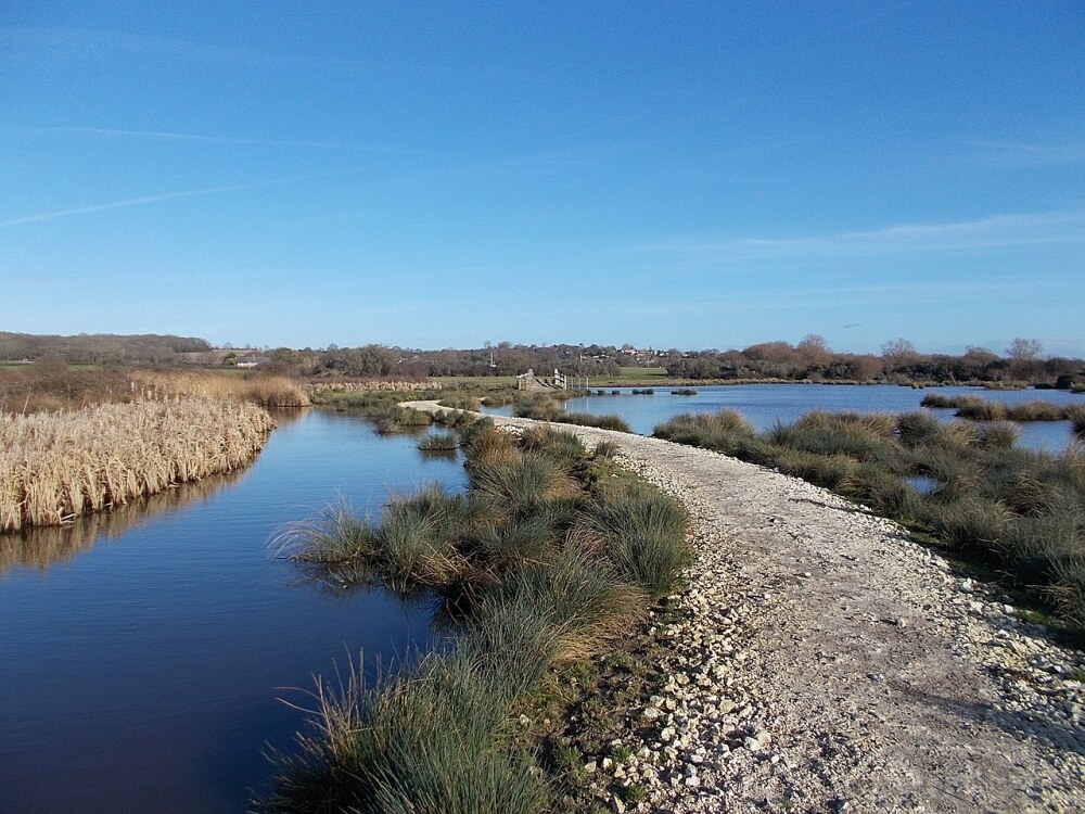 Brading Marshes Nature Reserve
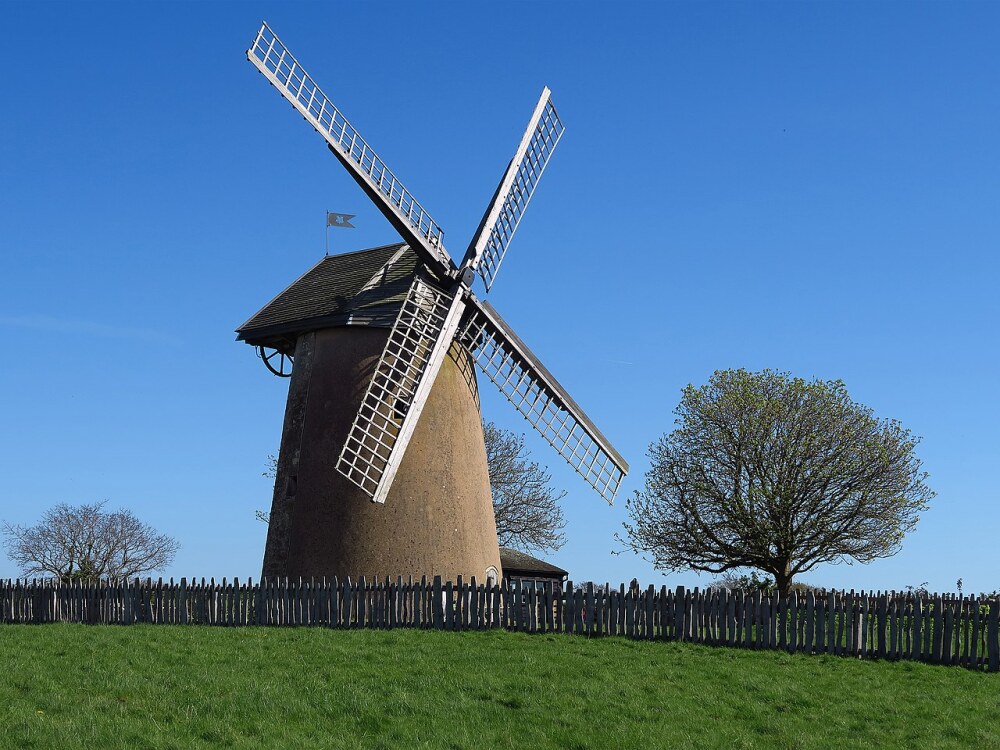 Bembridge Windmill
From the Church of St Mary, you leave the town by an old lane which gives access on to a causeway across the Brading Marshes, created by the damming of the Yar. Several varieties of duck cruise the shallow streams, while the thick sedge provides a nesting place for reed bunting and several types of warbler.
On the other side of the marshes, the route follows the Bembridge Trail through farmland next to the small local airport, to Bembridge Windmill. Four storeys high and built of local stone, the mill ground flower and meal, and later bran and cattle feed, for more than 200 years.
The windmill ceased production at the outbreak of World War One, but still retains much of its original 18th-century machinery. The National Trust now owns the mill and opens it to the public in the summer. Nearby there is a wooden bench seat encircling a tree, just right for a rest and a snack.
The walk goes through Steyne Wood, an old oak woodland carpeted with ferns and flowers, and past Bembridge public school to the clifftop above Whitecliff Bay. The view ahead is dominated by the sheer white cliffs of Culver Down, the most easterly point of the great chalk ridge, which serpentines across the middle of the island. Several species of gull are among the sea birds which nest on these cliffs, and peregrine falcons have been seen hunting here.
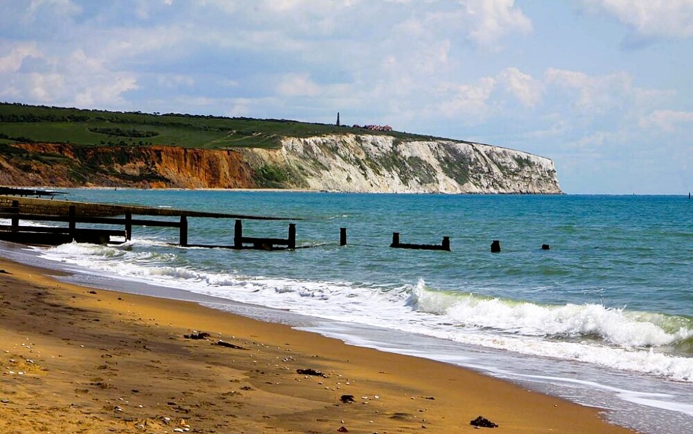 Culver Cliffs
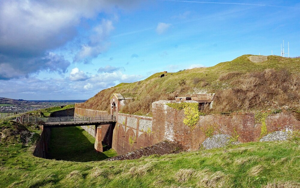 Bembridge Fort
There are wonderful views to be had from the beacon on top of the down - west over Sandown Bay and the English Channel, and east over Bembridge Harbour and the Solent to the mainland. The guns here are the remains of a battery established in 1902 to guard the approaches to the Spithead. The two emplacements of nine 2-inch breach-loading guns were in action during both World Wars, and were used for training purposes until 1956.
The walk takes a road along the crest of Bembridge Down, past a monument erected in 1849 to the first Earl of Yarborough, founder of the Royal Yacht Squadron. This road and its verges are owned by the National Trust. To encourage the growth of downland flowers, the Trust runs a flock of sheep on the land to close-crop the turf.
The National Trust also owns the land around Bembridge Fort, which was built between 1862 and 1867 as part of Lord Palmerston's sea defences. During World War One, its heavy artillery was used as a coastal defence, and in World War Two it was an anti aircraft post and the headquarters of the local Home Guard.
After descending from the downs onto a road, there are fine views to your right of Yaverland Manor, a Jacobean house built by the Richards family in 1620, and the restored Norman Church attached to it. The manor is private and best seen from the road. From here a short walk across the flanks of a chalk hill takes you back to the beginning of the causeway across the marshes, and thence back to the start of the walk in Brading.
Acknowledgment: Text derived from the Out and Out Series; Discovering the Countryside on Foot. Pictures courtesy of Wikipedia.


