Rye, Camber Castle and Winchelsea
Two land-locked former ports boasting a wealth of history
Google Maps Open Source Maps| Statistics and Files | ||
|---|---|---|
| Start: Strand Quay | Distance: 6.6 miles (10.6 km) | Climbing: 45 metres |
| Grid Ref: TQ 91723 20247 | Time: 3 hours | Rating: Easy |
| GPX Route File | Google Earth File | About Rye |
| Statistics | |
|---|---|
| Start: Strand Quay | Distance: 6.6 miles (10.6 km) |
| Climbing: 45 metres | Grid Ref: TQ 91723 20247 |
| Time: 3 hours | Rating: Easy |
| GPX Route File | Google Earth File |
Ordnance Survey Explorer Map (1:25,000)
The Walk: This circular walk links the picturesque Cinque Port towns of Rye and Winchelsea by way of Camber Castle. The original five Cinque Ports were Dover, Sandwich, Romney, Hastings and Hythe, formed into a confederation for the naval defence of England in the 11th century. The ancient towns of Rye and Winchelsea were added to these later in the century.
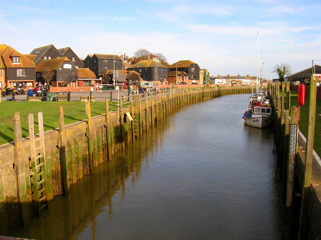 Strand Quay, Rye
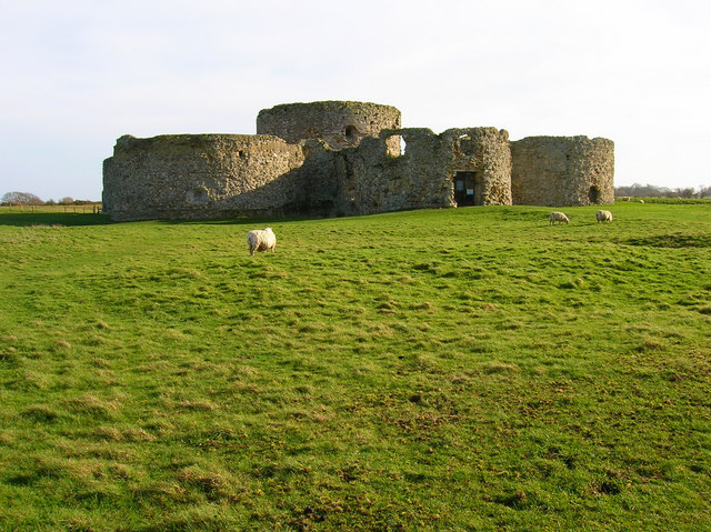 Camber Castle
The walk starts on Strand Quay in Rye, where the River Tillingham flows into the River Brede. Behind the tall 19th century wooden warehouses, now covered converted into restaurants, antique shops and the towns Heritage Centre, cobbled Mermaid Street climbs up to its famous 15th century inn. Built to cope with Rye's trade in the Tudor period, the quay still has a busy air. Although narrow, the tidal channel is still navigable for smaller craft, and the basin is usually filled with boats. On Winchelsea Street, you pass a boat builder, one of several still continuing this old Rye craft.
The path beside the lock gates of the River Brede curves across drained levels, where Romney Marsh sheep graze, towards Camber Castle. It is possible to walk the whole way around the outside of this castle, which was built in 1538 by Henry VIII as part of the shore defences of this vulnerable coast. Its design is smaller to that of Deal and Walmer castles; six semi-circular low bastions and a concentric inner tower provided a 360 degree field of fire for Tudor artillery. Built partly of local sandstone, the southernmost walls have been honeycombed by erosion. The castle once stood on the seashore, but the constantly changing shoreline has left Camber Castle stranded today amid the levels of the River Brede.
As the route heads towards Winchelsea, it is easy to see why Edward I chose this as the site of his new town in 1288. It is on a plateau that rises from the surrounded levels like an island. The steep sided southern escarpment is heavily wooded. In medieval times the sea came much closer, and the River Brede was navigable for large ships up to the town's quay. It was here that the Royal Fleet laid at anchor during King Edward's visit. The levels themselves, which are largely formed of sand and gravel, are drained by numerous ditches. Waterbirds find nesting places in the reeds and there is a nature reserve at nearby Rye Harbour.
After passing River Brede Farm, a lane leads across the Royal Military Canal, which was begun in 1804 as a defensive measure against the threat of Napoleonic invasion. The canal is 23 miles long and runs right across the Romney Marsh from Pett Level to Hythe. It is 62 feet wide and 9 feet deep.
You enter Winchelsea beside the timber framed Strand House on a road running steeply uphill towards the massive fortified 13th century Gatehouse. The grooves of the Portcullis can be seen on the inside of its arch. A short flight of steps beyond leads to a little shelter and garden and a superb look out point. The sea seems quite close and further west are the steep slopes of the Firehills and Fairlight.
Just beside the lookout is one of many houses in Winchelsea that still retain a medieval celler. Steps descend to the arched stone doorway and to the vaulted cellar within. With the independence bestowed on them by the Cinque Port charters, towns like Winchelsea and Rye were notorious smuggling centres. Contraband was often stored in these cellars, in the process of being shipped to and from the continent.
As a Cinque Port, Winchelsea was a Royal Town, and when Old Winchelsea was destroyed by the Great Storm of 1287, Edward I laid out new Winchelsea on the gridiron model of the bastides of south-west France. The roads all cross at right angles leaving regular square plots of some 2.5 acres. Edward had evidently planned for Winchelsea to house far more people than it eventually did, as many of the plots at the western side of the town remain as small fields. A combination of French raids, the Black Death and the silting up of the harbour limited the town's population.
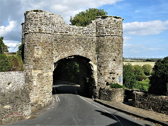 Strand Gate, Winchelsea
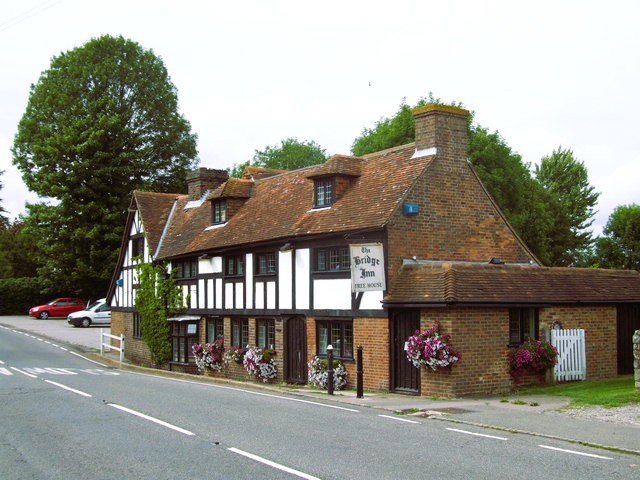 The Bridge Inn at Winchelsea
Up the High Street to the right is The Armoury, a 14th century building that got its name during the Napoleonic Wars. On the left is the Church of St Thomas. Today, only the chancel and parts of the aisles remain, but the early decorated windows are among the finest in Sussex. Authorities disagree as to whether this great church was damaged by French raids or simply never completed. In the north aisle are three effigies that are thought to have been salvaged from the destroyed Church of Old Winchelsea. In 1790, John Wesley preached his last open-air sermon in front of St Thomas's.
In the 14th century, Winchelsea suffered several attacks from the French and their allies. The most savage of these was on a Sunday in 1359, when the town was at Mass. A force of 3,000 French attacked the town and butchered many of the congregation. They were subsequently buried in the churchyard, which had to be enlarged for the purpose. Another attack took place the next year, and in 1380 a Castilian fleet of galleys under the command of Admiral Sancho de Tour 'fired Winchelsea and approaches to London'.
Across the High Street from the church is the 14th century Court or Town Hall, where the Mayor of Winchelsea is still elected every year. It also houses the towns little museum. A couple of turns along Winchelsea's tidy streets lead you to the site of St Leonards Mill. The black windmill, a feature of Winchelsea, was built in 1703 on the site of a Saxon church dedicated to this same saint. The mill was destroyed in the other great storm Winchelsea experienced, exactly 700 years after the first, in October 1987. Only the millstones remain to bear witness to its existence.
From the promontory there are wide views across the Brede Valley to Icklesham in the west, and the high ground of Udimore to the north. Below is the site of the town quay. Cargo was carried up wide, grassy tracks through the now vanished Land Gate, to the town.
The path at the bottom of this slope runs along the base of the escapement, which was once surmounted by an earthen embankment, to a little lane leading towards Winchelsea Station. The lane crosses the River Brede and continues across the railway towards the long gorse covered scarp of Cadborough Cliff. Hawthorns border this lane across the levels, and the hedgerows boast a profusion of wildflowers. It is, however, the huge sky above the level ground that is the most dominant feature. On a fine summer evening, the sunset is spectacular here.
The sandy slopes of Cadborough are host to numerous birds, and in the reeds along the ditches at its base are the nests of reed warblers and buntings. This delightful bridlepath follows the base of the cliff to Rye, now visible directly ahead as another island surfacing from the marsh, with the Church of St Mary in the centre rising above the surrounding roofs. On the outskirts of the town, you cross the grimly named Gibbet Marsh to the great white windmill, and return to the busy strand key.
Acknowledgment: Text derived from the Out and Out Series; Discovering the Countryside on Foot. Pictures courtesy of Wikipedia.


