Keston Common, Leaves Green and Holwood House
A rural walk free from the hustle and bustle of the nearby metropolis
Google Maps Open Source Maps| Statistics and Files | ||
|---|---|---|
| Start: Keston Common | Distance: 4.9 miles (7.9 km) | Climbing: 180 metres |
| Grid Ref: TQ 41619 63751 | Time: 3 hours | Rating: Moderate |
| GPX Route File | Google Earth File | About Keston |
| Statistics | |
|---|---|
| Start: Keston Common | Distance: 4.9 miles (7.9 km) |
| Climbing: 180 metres | Grid Ref: TQ 41619 63751 |
| Time: 3 hours | Rating: Moderate |
| GPX Route File | Google Earth File |
Ordnance Survey Explorer Map (1:25,000)
The Walk: It was on Keston Common that William Wilberforce resolved to start political action to abolish slavery in the British Empire. This area, on the very edge of south London, might be in deepest Dorset. When walking its quiet byways it is a good idea to take along a field guide to wild flowers, which grow in abundance along the shady paths.
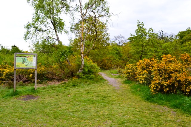 Keston Common
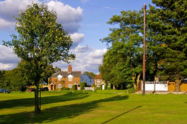 Leaves Green
A short stroll along Westerham Road from the picnic site at the beginning of the walk leads to a footpath down into the first of several delightful valleys which, in olden times, was the site of a Roman villa. You cross Jackass Lane to Blackness lane opposite, then follow a bridleway that wanders beyond a farm into seemingly remote country. This lovely shaded path has a profusion of wildflowers on both sides. Through a light screen of trees there are views of meadows and copses, orchards and hills. It is difficult to believe suburbia is so close.
The bridlepath climbs gently out of a valley, then drops down through wooded Furze Bottom. At the end of the wood, beyond a cluster of beech trees, there are wide views on both sides as the path climbs a ridge. After 1.5 miles, the path passes its first building, an isolated cottage, then leads downhill.
A copse is home to an unusual wildflower, the butterbur. Flowering between March and May, it has a thick fleshy pale pink stem and a tightly packed flowerhead. Country folklore says its leaves were used to wrap up butter, hence its name. The valley bottom has no stream. The surface water drains into the chalk of the North Downs. There is a steepest climb out of the valley, which runs southwards, almost in a straight line, for quite some distance. A lane leads to a plateau of carefully tended commonland, Leaves Green.
On the corner of the common is the King's Arms, an old white weather-boarded inn with heavy beams within. Beyond it is Milking Lane. Though cows are no longer herded here, the farm buildings are still around the corner, converted for modern use.
A road across the common passes the flint-faced former workhouse of Cudham parish. The villagers fulfilled their statutory obligation of building a workhouse for the relief of the unemployed poor in 1731, but placed it out of sight on the edge of the parish, some two miles from the village. Today it has been converted into a pretty cottage. Close by is another cottage, the Ramblers Rest, which in bygone days served teas to weary walkers.
 Taking off from Biggin Hill
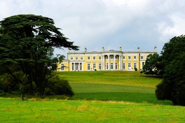 Holwood House
From Leaves Green, a wide path crosses a huge field at the edge of the runway of Biggin Hill Airfield. Biggin Hill was a key fighter station in the Battle of Britain between the 10th of July and the 31st of October, 1940. Royal Air Force spitfires and hurricanes, directed by the newly invented and top secret radar, intercepted waves of German bombers sent to prepare for an invasion of Britain, in a plan called named Sea Lion. Such were the losses sustained by the German Air Force that the whole invasion was postponed indefinitely.
At the height of the fighting, 17 hurricanes of 32 Squadron and 15 spitfires of 610 Squadron, were flying from the airfield. The strength of other fighter stations were similar. The pilots, ever alert, often slept beneath their planes using their parachutes as pillows.
The airfield was bombed, and at one time, a shop in the village had to be converted into an ops room. A Spitfire and a hurricane are on view at Biggin Hill, which, for 75 years, was a Royal Air Force station with the RAF operate only departing in 1992. The airfield is still in use today as the commercial London Biggin Hill Airport, and the path you walk along is a popular airplane spotters location.
The path across the field ends at Shire Lane. At Holwood Farm, another field path climbs the lovely slopes towards the Holwood estate, which was once owned by William Pitt. It was on this hill among the old oaks crowning its summit, and in sight of Holwood House, that William Wilberforce and Pitt paused to admire the view and discuss Wilberforce's momentous proposal for the abolition of slavery in 1787.
The path continues through The woodlands, past other ancient oak trees, to Westerham Road. To the left is the car park and to the right, and open on several days a year, is the entrance to Holwood, with its lovely grounds and sweeping views.
Acknowledgment: Text derived from the Out and Out Series; Discovering the Countryside on Foot. Pictures courtesy of Wikipedia.


