Donnington Castle, Bagnor, Winterbourne and Snelsmore Common
Explore a tranquil area of rural Berkshire with a turbulent past
Google Maps Open Source Maps| Statistics and Files | ||
|---|---|---|
| Start: Donnington Castle | Distance: 6.8 miles (11.0 km) | Climbing: 165 metres |
| Grid Ref: SU 46036 69104 | Time: 3 hours | Rating: Moderate |
| GPX Route File | Google Earth File | Visit Donnington Castle |
| Statistics | |
|---|---|
| Start: Donnington Castle | Distance: 6.8 miles (11.0 km) |
| Climbing: 165 metres | Grid Ref: SU 46036 69104 |
| Time: 3 hours | Rating: Moderate |
| GPX Route File | Google Earth File |
Ordnance Survey Explorer Map (1:25,000)
The Walk:
The market town of Newbury, which grew up around the confluences of the River Kennet and River Lambourn, presides over an area of peaceful well-wooded country. Just to the north, one of the most bitterly contested battles of the Civil War was fought. The Second Battle of Newbury took place on 27th of October 1644, when the Royalist Army was led by Charles I himself.
This circular walk begins beneath the ruined gatehouse of Donnington Castle, when it was besieged by the Parliamentary army. Donnington Castle held out for an epic 20 months. During the battle, the castle's guns pinned down the left wing of the cavalry commanded by Oliver Cromwell.
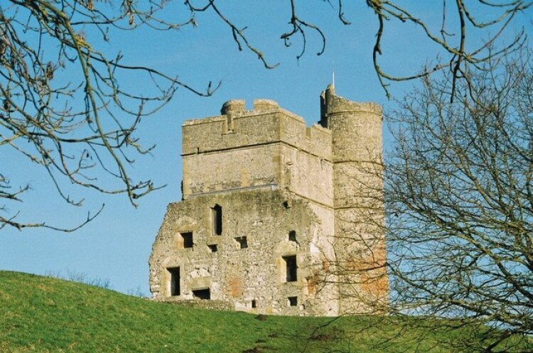 Donnington Castle
 River Lambourn at Bagnor
A path passes under the castle's gun emplacements and enters a wood. Soon afterwards, a lovely view unfolds to the south, across the River Lambourn. The Royalists met the Parliamentarians near here, as they fought for control of the small village of Speen on the other side of the river. The path is pleasantly shady and is conveniently planked in several marshy places.
As it turns downhill, across a narrow neck of the golf course, the path is at once enclosed between thick hedgerows of dog rose. Similar hedges must have obstructed Cromwell's army of the Eastern Association, as they undertook their 13-mile night march in an attempt to outflank the foot royalists.
A gravel drive leads you to a road beside the Blackbird pub in the village of Bagnor. Just a little further along, a bridge crosses a little stream, the Winterborne, just before it enters the River Lambourn. Close by is an old water mill. This was once the site of a fulling mill. With the end of the wool industry in Berkshire, it became a corn mill and was later used to manufacture paper.
It is well worth walking along the lane beside the bridge to see this lovely old building and its beautiful garden. Since 1967, the mill has been home to the Watermill Theatre, visited by touring repertory companies that have staged many shows in the 190 seat auditorium.
The drive of Bagnor Manor leads to a bridlepath that climbs up onto the rolling Berkshire Downs. Enclosures in the 16th and 17th centuries, along with the fall in demand for cloth, led to the end of the wool industry upon which much of Newbury's wealth was founded. It was also the end for the fine grasslands which supported a rich variety of flowers and wildlife, as sheep pasture gave way to arable fields. Today, crops like flax bring unexpected splashes of colour to the one green hills.
Wildflowers still grow everywhere, and poppies continue to make a determined stand in the cornfields on Mound Hill. From this vantage point, there is a panorama of rolling hills, dotted with thick clumps of oak or ash trees.
The straight path continues from the wooded hilltop, across fields to the lovely wood round Boxford Common. A steepish ascent through the trees brings you to the open land of the common itself. A well maintained wood at the far end of the common leads to a quiet, shady road which rises and falls with views to the south over parkland and woods. On the night of 26th of October 1644, it presented a different appearance as cavalry, artillery and infantrymen of the Parliamentary army clattered over its rough surface in an attempt to outflank the Royalist army.
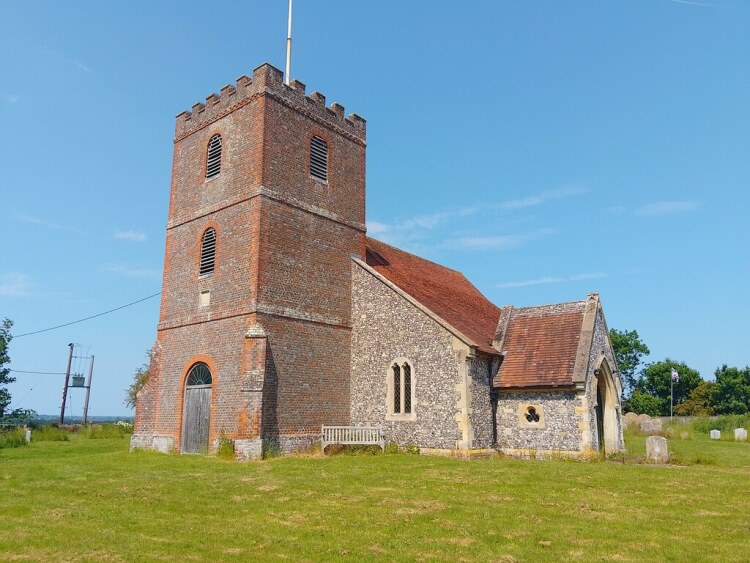 Winterbourne Church
 Heather blossom on Snelsmore Common
The road goes to Winterbourne Manor. The red-brick manor house looks early Victorian, but a walk down the lane beside its wall, to a large gateway, reveals a much older brick and timber-frame building, probably Tudor, with a mullioned upper story window.
Opposite is the Church of St James the Less. The red brick tower is probably contemporary with the older part of the manor, but the interior has been heavily restored.
The village of Winterbourne, at the foot of sloping fields, contains a number of restored, half-timbered, thatched houses and the pretty Winterbourne Arms. Opposite the inn is Winterbourne stream. Its name suggests that it has generally been seasonal, drying up here in the summer months. The white painted bridge crossed by the path may serve no purpose for half of the year.
You go through fields and spinneys into a remarkable wildflower meadow, never treated with any kind of chemical weedkiller. From spring to autumn, every imaginable type of meadow flower makes it a riot of colour. The owner has carefully mown a neat wide path across this carpet of flowers.
The route joins a country road at a lovely early Georgian house, Winterbourne Holt, then crosses Snelsmore Common. It goes over an ancient low earth embankment, Black Ditch, whose origin and purpose are a mystery. It stretches for a quarter of a mile to the west and may have marked a boundary.
The 146 acres of Snelsmore Common Country Park are rich in the flora and fauna of heathland. Birds visiting in summer include grasshopper warblers and nightjars. And among the rarer plants are heath spotted orchids and sundew. The walk passes a recreation area equipped with picnic tables and a tall wooden watch tower near the southern extremity of the park.
Soon, along the broad track that leads from the park gate, Donnington Castle comes into view ahead. Past Castle Farm, the gate on your right gives access to the castle and its precincts, from which the commanding view of the valley and strategic importance of the castle in the battle can best be appreciated.
Acknowledgment: Text derived from the Out and Out Series; Discovering the Countryside on Foot. Pictures courtesy of Wikipedia.


