Cobham, Henley Street, Luddesdown and Great Buckland
A walk to some lovely villages on the dip of the Kent Downs
Google Maps Open Source Maps| Statistics and Files | ||
|---|---|---|
| Start: Cobham | Distance: 6.2 miles (10.0 km) | Climbing: 286 metres |
| Grid Ref: TQ 67006 68438 | Time: 3 hours | Rating: Moderate |
| GPX Route File | Google Earth File | About Cobham |
| Statistics | |
|---|---|
| Start: Cobham | Distance: 6.2 miles (10.0 km) |
| Climbing: 286 metres | Grid Ref: TQ 67006 68438 |
| Time: 3 hours | Rating: Moderate |
| GPX Route File | Google Earth File |
Ordnance Survey Explorer Map (1:25,000)
The Walk:
Just five miles away from the busy towns of Gravesend and Rochester, is a lace-like network of lanes and footpaths. The Neolithic men who established these paths erected storm circles and standing stones that made the Medway Valley a religious centre to rival Salisbury Plain and Stonehenge.
This walk through the enchanting remote download countryside visits two historic villages. The first, Cobham, where the walk begins, was settled by the Anglo-Saxons shortly after the Roman villa in Cobham Park was abandoned. It stands 360 feet above sea-level and is dominated by the Church of St Mary Magdalene, built of downland flint with a Kentish ragstone tower. The collection of memorial brasses in its 13th-century chancel is the largest in the world. The brasses date from 1320 to 1539.
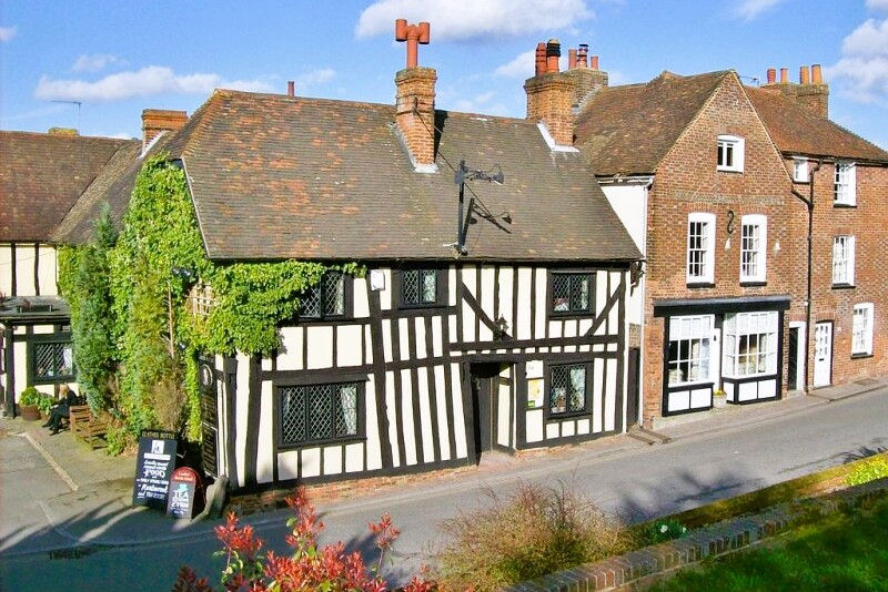 Leather Bottle Inn, Cobham
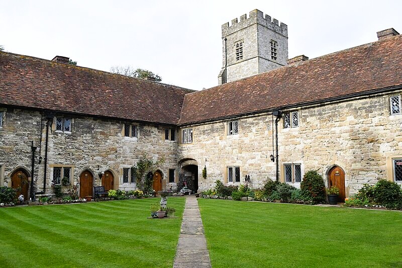 Courtyard of Cobham College
The main series of brasses portray the de Cobhams and the Brookes, Lords of the Manor of Cobham. Two of the finest are memorials to husbands of Lady Joan Cobham, who was widowed five times. Sir Reginald Braybrok died in 1405 and Sir Nicholas Hawberk in 1407. Both their brasses show their little sons standing on pillars at their feet.
In the centre of the chancel is a large alabaster tomb chest. erected in 1561 and dedicated to Sir George Brooke, the 9th Lord Cobham. The design and setting of this elegant tomb, with its fashionable renaissance detail, speaks of pride rather than humility in death.
Just beyond the church are the delightful ragstone buildings of the New College and Almshouses, set around a grassy quadrangle. In 1370, Sir John de Cobham founded a college here for priests, who were employed to sing masses for the souls of the de Cobham family. Originally there were two quadrangles, one on either side of the Great Hall, which was used for dining and other communal activities.
These 'chantries' were abolished during the Reformation. The buildings fell into ruin, but were adapted near the end of the 16th century to provide housing for the aged and poor.
The Great Hall still has its 14th-century roof. A candle placed on a stone bracket on the south wall gave light for someone to read to the priests at meal time. South of the hall lay the second quadrangle. A great fireplace in the garden shows where the medieval kitchen was.
As you walk out of the village, you pass through typical downland woods and pasture full of flints. The bigger flints were gathered in winter by peasants, temporarily free from the agricultural treadmill, and used to build churches, houses and farms.
Are you descend towards Luddesdown, one of the prettiest cricket pitches in the country can be seen in the natural amphitheatre below. There is room for thousands of spectators on the hillside to the north.
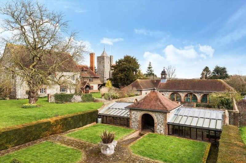 Luddesdown Court and Luddesdown Church
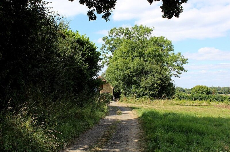 Country lane beside Henley Wood
The natural secure site of Luddesdown village has long been appreciated. Flint tools have been found here. Early cultivation terraces run along the hillside above the Buckland Road near Hatch Hill. There are fallen sarsen stones in the woodland on the opposite slope.
Hatch Hill gets its name from the gate onto the common woodlands of the high downs for the herds of pigs and cattle that were driven here from Thames-side settlements. 'Luddesdown' means the hill of Hlud, a Celtic god of plenty, suggesting an old sacred sight.
The church and manor house, both flint built, appear in the valley bottom, in a hollow wrapped round by hills. The group is typical of the small Kentish manor. If there were any tenants timber-framed cottages around, they have long gone.
The manor, Luddesdown Court, is one of the oldest inhabited houses in the country. Parts date from about 1240, though it is difficult to date flint buildings precisely. The remains of an Iron Age house were found in the foundations, so many houses may have existed on this site.
The Church of St Peter and St Paul was rebuilt in 1866. Few original features survived from the medieval church. Inside the tower is a 13th-century belfry ladder, with steps cut from solid blocks of wood.
From Luddesdown to Great Buckland, the valley on the left is so smooth and rounded it looks like a giant's bowling alley. Great Buckland Farm has an unusual pond with ducks and geese. The water's edges lined with flints that stop the ground being churned up by horses coming to drink.
The Cock Inn is a welcome break on the way back to Cobham. As well as many hundreds of beer mats, there is a collection of World War Two memorabilia, as well as books to browse through while you relax.
The new churchyard at Cobham affords a view of the north bank of the River Thames, with its power stations and chimney stacks. A wooden memorial seat to a Trinity House pilot is a further reminder of the proximity of the industrial Thames.
Opposite the church, and back at the start of the walk, is the Leather Bottle Inn. This was a favourite hostelry of Charles Dickens, who towards the end of his life lived at nearby Gad's Hill. Mister Pickwick and his friends visit the Leather Bottle in The Pickwick Papers.
Acknowledgment: Text derived from the Out and Out Series; Discovering the Countryside on Foot. Pictures courtesy of Wikipedia.


