Hythe, Saltwood, Pedlinge, Lympne Castle and Royal Military Canal Path
Visit three different castles built to guard the Channel coast
Google Maps Open Source Maps| Statistics and Files | ||
|---|---|---|
| Start: Hythe | Distance: 8.6 miles (14.0 km) | Climbing: 186 metres |
| Grid Ref: TR 16070 34674 | Time: 4 hours | Rating: Moderate |
| GPX Route File | Google Earth File | About Hythe |
| Statistics | |
|---|---|
| Start: Hythe | Distance: 8.6 miles (14.0 km) |
| Climbing: 186 metres | Grid Ref: TR 16070 34674 |
| Time: 4 hours | Rating: Moderate |
| GPX Route File | Google Earth File |
Ordnance Survey Explorer Map (1:25,000)
The Walk:
The Kent coast was always seen as the key to the conquest of England. At the beginning of their occupation, the Romans built great show fortresses at the natural harbours of Reculver, Richborough, Dover and Stutfall, to the west of Hythe, to defend their new territory.
Later, Jutish and Saxon invaders settled here, and in turn, fought off Viking raiders. The medieval French launched raids along the Kent and Sussex coasts, and both Napoleon and Hitler planned to land invasion forces along these same shores.
The walk explores a stretch of this bulwark coast. It starts in the traffic free High Street of Hythe, once a seaport and still a military town, and heads along Great Conduit Street to a pretty lane, Church Hill.
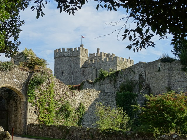 Saltwood Castle
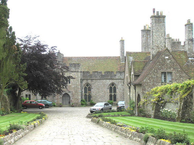 Lympne Castle
On the corner of Church Hill is Centuries, a 12th-century house, extended in 1334 by Haymo, Bishop of Rochester, as a medieval hospital. Church Hill climbs to St Leonard's church, which is famous for its superb early English chancel and for its crypt. There is a huge display of human skulls and bones. From the steps of the south porch, there is a wide view over the town and the English Channel beyond.
You leave the town behind on a path that climbs a gentle slope above a pretty valley. As it levels out, the route joins a track that was almost certainly the original route to Saltwood Castle. The towers of the outer curtain wall soon come into site, and the track follows the wall around to the magnificent 14th-century gatehouse. Although the castle is rarely open to the public, the path affords an excellent view. See opportunites to visit the castle here.
The castle was built in the 12th century, probably in the troubled reign of King Stephen, on a site given to the church by Canute in 1027, and became the home of the Archbishop of Canterbury. Henry II confiscated it during his rift with Thomas a Becket. The four knights met here to plan Becket's assassination on 28th December 1170.
According to tradition, they sat in the Great Hall, the candles extinguished so they could not see each other's faces. The next day they rode to Canterbury and killed Becket in the cathedral. Saltwood Castle was returned to the church by King John. Beyond is the pretty little Norman Church of St Peter and St Paul, which contains a good copy of a 17th century painting by Murillo of the Virgin and Child.
A bridleway beside an orchard leads to Willow Wood, where the route joins a long distance path, the Saxon Shore Way. You pass a fine medieval half timbered Yeoman's house at Slay Brook. A field path leads on to the lovely Chesterfield Wood and then to the high plateau of Pedlinge, where views open out, ahead to the sea, and behind to the Downs at Summerhouse Hill.
Beyond the duck pond at Oxenden Farm, you join the former Roman road near Lympne. As the road rises, it meets a lane climbing the hillside from the sea. An elegant, slender cross here bears a delicate carving of the Crucifixion. It was presented in 1923 by the Warden of the Cinque Ports to mark the site of the medieval Shepway Cross.
The Shepway, a corruption of 'sheepway', was an ancient route on the line of the Roman road from Portus Lemanis to Canterbury. It gave its name to the ancient Court of Shepway, which had jurisdiction over the whole of Romney Marsh. In 1358, the court was attended by 65 barons of the Cinque Ports. Today, it is presided over by the Lord Warden of the Cinque Ports.
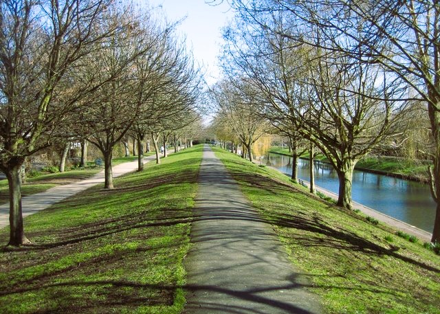 Royal Military Canal Path
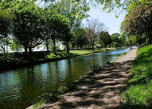 Royal Military Canal at Hythe
Further on is the drive to Lympne Castle, which stands beside a low, massively walled Norman church. In a corner of the churchyard are the graves of two pilots killed in the Battle of Britain. Lympne Airfield, now Ashford Airport, was home to fighter aircraft in both World Wars.
Lympne Castle's clifftop vantage point commands views over the marsh and across the Channel to the French coast. The Romans chose this site for a watchtower, giving early warning of Saxon invaders to the busy port of Portus Lemanis below.
Arguably, Lympne is not a castle, but a fortified residence built for the Archdeacon of Canterbury. It has no moat or curtain wall, but its towers and its position on the cliff edge would have provided some security from French Raiders. And that was probably the reason for the west tower's construction in 1380.
The stones for both the castle and the church were taken from the ruins of Stutfall Castle, a Roman shore fort occupying a site of some ten acres, built to protect the natural harbour below. A path runs along the edge of the cliff before descending the sloping fields and passing the ruins of the fort. Great boulders of concrete conglomerate lean at crazy angles along the grazing sheep, remains of walls 20 feet high and 12 feet thick. The strange angles were caused by landslips, one of which led to the forts evacuation in AD 370. Natural forces were also responsible for the disappearance of Portus Lemanis. The sea receded, the river changed course, and the harbour became a part of the marsh.
Running along the edge of the marsh and below the cliff escarpment is the Royal Military Canal, which was begun in 1804 to protect the coast against then very real threat of a Napoleonic invasion. Nelson's victory at Trafalgar established the supremacy of the English fleet, which took control of the Channel. The invasion was prevented, and the canal was never put to the test. Today, it is the tranquil waterway useful for draining the marsh, and a habitat for dragonflies and water birds. Beside it, a wide, flat, grassy embankment provides an easy walk for the 2.5 miles back into the centre of Hythe.
A few hundred yards along the bank is a canal cutting that serves Dymchurch. Just below the bridge at West Hythe, the remains of St Mary's Church become visible to the left. West Hythe was another coastal town that enjoyed a brief period of prosperity as a port, before the receding sea left it high and dry.
The hillside beyond the church ruins, called the Roughs, was once used for military manoeuvres. In the 19th century, the Army established its School of Musketry at Hythe and from the ranges on the shingle west of the town, the rattle of rifle fire was frequently heard.
Another unusual distant sound on the peaceful canal walk is that of a steam train's whistle. It comes from the famous little engines of the Romney, Hythe and Dymchurch Railway, whose line runs between the canal and the shore.
Acknowledgment: Text derived from the Out and Out Series; Discovering the Countryside on Foot. Pictures courtesy of Wikipedia.


