Lamorna Cove, Boskenna and the Merry Maidens
Over clifftops and past ancient monuments with stunning seascape views
Google Maps Open Source Maps| Statistics and Files | ||
|---|---|---|
| Start: Lamorna Harbour | Distance: 5.4 miles (8.6 km) | Climbing: 312 metres |
| Grid Ref: SW 45014 23994 | Time: 2-3 hours | Rating: Moderate |
| GPX Route File | Google Earth File | About Penwith |
| Statistics | |
|---|---|
| Start: Lamorna Harbour | Distance: 5.4 miles (8.6 km) |
| Climbing: 312 metres | Grid Ref: SW 45014 23994 |
| Time: 3 hours | Rating: Moderate |
| GPX Route File | Google Earth File |
Ordnance Survey Explorer Map (1:25,000)
The Walk: Lamorna Cove is an ex-fishing quay on one of West Penwith's most delightful sections of coastline. It lies within the Cornwall Area of Outstanding Natural Beauty as does all of this walk. Most of the coastal section of the walk crosses the gentle seaward flanks of the surrounding countryside, occasionally ascending to a stunning viewpoint, but mainly staying sheltered from the full effects of the wind.
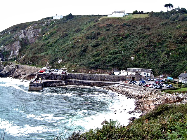 Lamorna Harbour
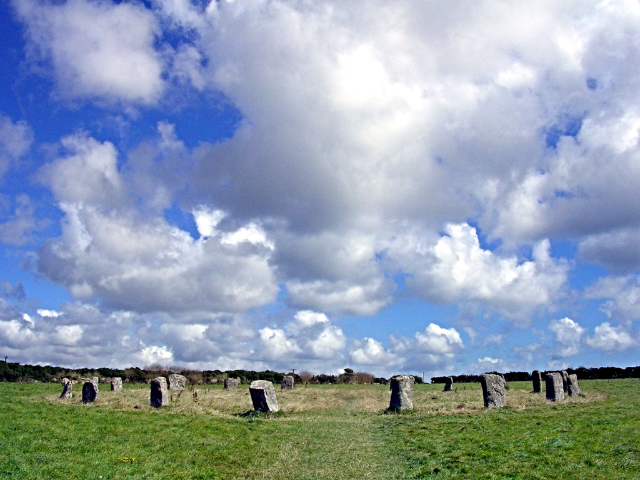 Merry Maidens Stone Circle
The most spectacular view of Lamorna Cove is from the flat topped stone quay breakwater and harbour at the beginning of the walk. In front, there is an unbroken view out across the sea. As the path rises up to Lamorna Point, a Celtic fashioned stone cross can be seen just below it. On the seaward side, an inscription reads something like 'EWW, May 13, 1873'. Speculation relates it to the wrecking of the Garonne in May 1868, when the bodies of two young girls were washed ashore.
The rocky pinnacled summit of Carn Barges offers an excellent view across to the lighthouse standing above the cliffs of Tater-du. Crowning the summit at Boscawen Point is an impressive jumble of granite pinnacles and blocks. In the breeding season, a colony of herring gulls will be visible just across the top of the cliff. Down the hill and past the meadow, a glade of stunted oaks offer dappled shade, and next, by contrast, St Loy's Cove, presents an array of crystalline rock.
After leaving the coastline, walking inland and passing the hamlet of Boskenna the road leads rapidly to the St Buryan junction. On the right is the distinctive Boskenna Cross. On a widened verge a little further along the road, close inspection of a pile of granite blocks reveal the tomb like structure of Tregiffian Barrow. Further on, the Merry Maidens stone circle dates from 2500 to 1500 BC. In the fields beyond to the north, the Pipers are two tall granite standing stones positioned 100 yards apart, said to be the largest standing stones in Cornwall. The finale of the walk is a gentle walk through the village of Lamorna and back down to the harbour.
Acknowledgment: Text derived from the Out and Out Series; Discovering the Countryside on Foot. Pictures courtesy of Wikipedia.


