Venford Reservoir and Bench Tor
A walk to view the Dart valley from the gritstone outcrops of Bench Tor
Google Maps Open Source Maps| Statistics and Files | ||
|---|---|---|
| Start: Venford Reservoir | Distance: 3.0 miles (4.7 km) | Climbing: 184 metres |
| Grid Ref: SX 68817 70899 | Time: 2 hours | Rating: Easy |
| GPX Route File | Google Earth File | About Dartmoor |
| Statistics | |
|---|---|
| Start: Venford Reservoir | Distance: 3.0 miles (4.7 km) |
| Climbing: 184 metres | Grid Ref: SX 68817 70899 |
| Time: 2 hours | Rating: Easy |
| GPX Route File | Google Earth File |
Ordnance Survey Explorer Map (1:25,000)
The Walk: The walk begins and ends on gentle moorland slopes, the remnants of an ancient valley of an ancestor of the River Dart. From Bench Tor, perched on a wooded hill, the view suddenly opens out to take in the marvellous deep Dart gorge. Then it is back through woods and across open moorland, with its heather, gorse and bracken, to yet another habitat, this one man made, the Venford Reservoir.
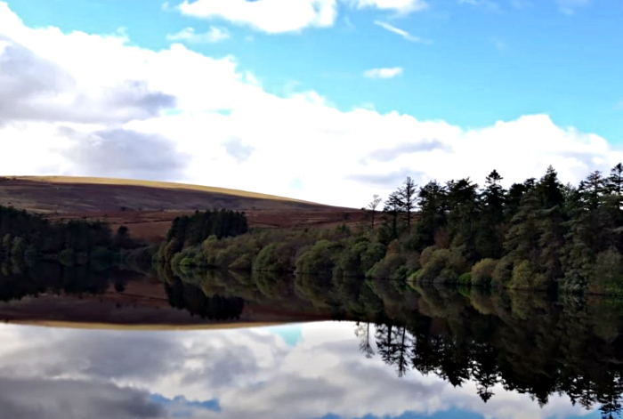 Venford Reservoir
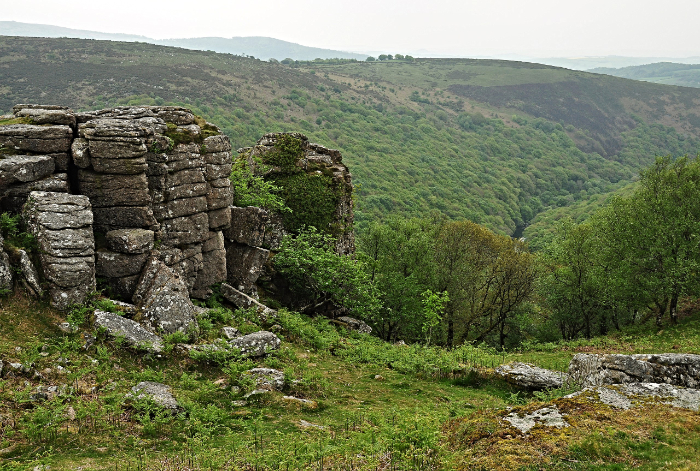 Bench Tor
The wild landscape of Dartmoor was created 290 million years ago when a volcanic eruption forced molten granite into the overlying soft rock. Erosion gradually exposed the hard granite, and alternate freezing and thawing broke up the granite to form the strangely shaped tors which are so typical of Dartmoor. Around the base of the tors lie the debris of fallen rock known as 'clitter'. The name tor comes from 'twr' the Celtic word for tower, which well describes their presence on the moor.
Bench Tor is a series of slabbed granite outcrops, about half a mile long, at the edge of the moor and on top of a steep wooded slope, dropping 500 feet to the River dart below. From the southern end of the tor the most breathtaking views of the Dart gorge can be seen. Bench Tor, perched on the edge of the valley, is a good example of how tors are formed. Because of its situation, erosion is most effective and gravity allows the eroded boulders to fall away very easily. 'Dart' comes from an ancient British word meaning 'oak' and below Bench Tor lies a dense oak wood, coppiced for centuries for its bark, to help in tanning leather, and for firewood and charcoal. Here redstarts and pied flycatchers sing in early summer and wood warblers trill close to the path.
Up the tributary valley of the Venford Brook, oaks give way to birch, rowan and sallow under which dippers and grey wagtails find good feeding. The dam of Venford Reservoir, built in thew 1930's, is masked by tall larches, pines and spruces. Coal tits and siskins revel in this different habitat, and the little reservoir, with its narrow plantation, provides an artificial oasis for wildlife in the midst of a moorland desert.
Acknowledgment: Text derived from the Out and Out Series; Discovering the Countryside on Foot. Pictures courtesy of Wikipedia.


