Kimmeridge, Steeple, Grange Arch and Ridgeway Hill
A lovely walk with panoramic views from the Purbeck Hills
Google Maps Open Source Maps| Statistics and Files | ||
|---|---|---|
| Start: Kimmeridge | Distance: 4.9 miles (7.8 km) | Climbing: 307 metres |
| Grid Ref: SY 91692 79895 | Time: 2-3 hours | Rating: Moderate |
| GPX Route File | Google Earth File | About the Purbeck Hills |
| Statistics | |
|---|---|
| Start: Kimmeridge | Distance: 4.9 miles (7.8 km) |
| Climbing: 307 metres | Grid Ref: SY 91692 79895 |
| Time: 2-3 hours | Rating: Moderate |
| GPX Route File | Google Earth File |
Ordnance Survey Explorer Map (1:25,000)
The Walk: The Isle of Purbeck is steeped in stories of smuggling, shipwrecks and failed commercial exploitation. Though its landscape bears a few scars from these latter ventures, its daunting sea cliffs and the absence of any major coastal haven for ships have helped to preserve its largely unspoilt and mainly agricultural character. The tiny village of Kimmeridge consists of a few stone cottages overlooking a treacherous bay which is surrounded by crumbling cliffs of bituminous shale. On Hen Cliff, to the east of the bay stands Clavell Tower. Built as a summer house in 1817 for the local squire, it is now derelict. On the opposite headland, though thankfully less conspicuous, is the site of Britain's first commercial oil well. The well has been in production since 1959. These features can be seen during the walk, as can a good view of the dramatic surrounding coastline.
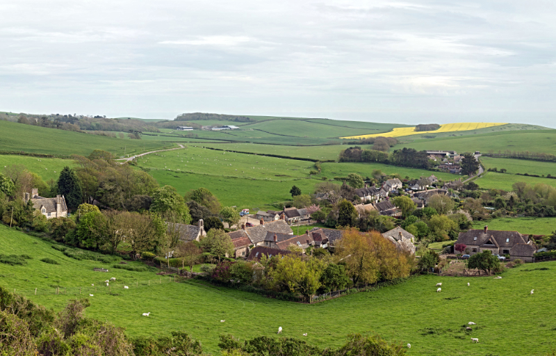 Kimmeridge, Dorset
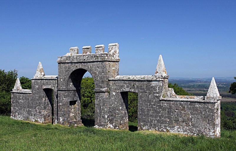 Grange Arch Folly
On Ridgeway Hill there is an excellent viewpoint. The seaward view, south-east to south-west, spans over 30 miles, while the prospect northwards gives a remarkable panorama of Wareham, Poole Harbour, Sandbanks and beyond to Christchurch Bay and Hengistbury Head. Grange Arch Folly was built in the early 18th century. Its purpose was to provide a focal point on the horizon when viewed from Creech Grange, lying in the valley below. The arch has been in the care of the National Trust since 1942. Denis Bond, who commissioned this strange folly, is perhaps more celebrated for the considerable engineering feat of laying out London's Bond Street on which was then a marshy refuse tip.
From the 'crossroads' on the Ridgeway track, virtually the whole remaining length of the Purbeck Hills can be seen ahead - to Corfe in the middle distance and onwards to Swanage on the horizon. Corfe lies in the only break in this line of hills and its shattered castle, ruined during the Civil War, can be viewed to the south of the ridge. The route from Whiteway Farm to Hyde Wood is characterised principally by the absence of any clear track, though there are enough points of reference to make navigation fairly straightforward.
Cresting the rise from Hyde Wood you again come in sight of the breezy expanse of Kimmeridge Bay. The rugged seascape stands in sharp contrast to the more pastoral scenery of the previous mile. The downhill path to St Nicholas' Church provides an opportunity to contemplate the memorable view as it gradually disappears from sight during the final descent.
Acknowledgment: Text derived from the Out and Out Series; Discovering the Countryside on Foot. Pictures courtesy of Wikipedia.


